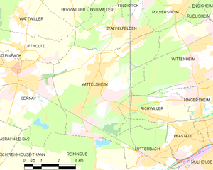
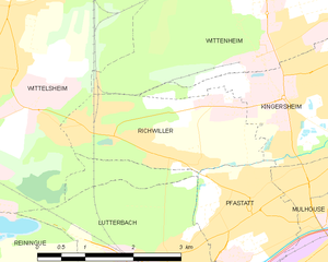
Richwiller (Richwiller)
- commune in Haut-Rhin, France
Richwiller, located in the Alsace region of France, is surrounded by beautiful landscapes and natural areas that offer great hiking opportunities. Here are some key points to consider when hiking in and around Richwiller:
-
Trail Options: There are several trails in and near Richwiller that cater to various skill levels. You can find short, easy walks as well as more challenging hikes that take you through the picturesque Alsatian countryside.
-
Nearby Natural Reserves: The nearby Parc Naturel Régional des Ballons des Vosges offers excellent hiking routes, showcasing stunning views, diverse flora and fauna, and the scenic beauty of the Vosges mountains.
-
Historical Sites: While hiking, you can also explore historical landmarks that are prevalent in the region, adding a cultural element to your outdoor experience.
-
Seasonal Considerations: The best time for hiking in Richwiller is typically from spring through fall when the weather is mild. However, winter hikes can also be enjoyable, particularly if you’re equipped for colder conditions.
-
Preparation: Always prepare adequately by wearing appropriate footwear, carrying enough water and snacks, and informing someone of your plans. GPS or a hiking map can be beneficial to navigate trails.
-
Local Tips: Engage with local hiking groups or guides for insider knowledge on the best trails and any hidden gems in the area. They can also provide updates on trail conditions and safety.
-
Respect Nature: As with any hiking expedition, it's important to follow "Leave No Trace" principles to preserve the natural beauty of the region.
Exploring the rich culture and scenic beauty of Richwiller and its surroundings through hiking can be a rewarding experience for nature lovers and adventure seekers alike.
- Country:

- Postal Code: 68120
- Coordinates: 47° 46' 45" N, 7° 16' 50" E


- GPS tracks (wikiloc): [Link]
- Area: 5.55 sq km
- Population: 3590
- Wikipedia en: wiki(en)
- Wikipedia: wiki(fr)
- Wikidata storage: Wikidata: Q148841
- Wikipedia Commons Category: [Link]
- Freebase ID: [/m/03nstnb]
- Freebase ID: [/m/03nstnb]
- GeoNames ID: Alt: [2983637]
- GeoNames ID: Alt: [2983637]
- SIREN number: [216802702]
- SIREN number: [216802702]
- BnF ID: [152719727]
- BnF ID: [152719727]
- VIAF ID: Alt: [242303253]
- VIAF ID: Alt: [242303253]
- GND ID: Alt: [4685746-1]
- GND ID: Alt: [4685746-1]
- INSEE municipality code: 68270
- INSEE municipality code: 68270
Shares border with regions:


Kingersheim
- commune in Haut-Rhin, France
Kingersheim is located in the Alsace region of northeastern France, near the city of Mulhouse. While the area may not be as famous for hiking as some other regions, it does offer opportunities for outdoor enthusiasts to explore the beautiful landscapes and nature surrounding the town. Here’s what you can expect when hiking in and around Kingersheim:...
- Country:

- Postal Code: 68260
- Coordinates: 47° 47' 29" N, 7° 20' 17" E


- GPS tracks (wikiloc): [Link]
- Area: 6.69 sq km
- Population: 13143
- Web site: [Link]


Pfastatt
- commune in Haut-Rhin, France
Pfastatt is a commune located in the Grand Est region of northeastern France, specifically in the Haut-Rhin department. While it may not be as widely known as some of the larger hiking destinations in France, it offers some charming outdoor experiences, particularly for those who enjoy exploring the Alsace region's natural beauty....
- Country:

- Postal Code: 68120
- Coordinates: 47° 46' 8" N, 7° 18' 6" E


- GPS tracks (wikiloc): [Link]
- Area: 5.24 sq km
- Population: 9423


Cernay
- commune in Haut-Rhin, France
- Country:

- Postal Code: 68700
- Coordinates: 47° 48' 24" N, 7° 10' 33" E


- GPS tracks (wikiloc): [Link]
- Area: 18.04 sq km
- Population: 11608
- Web site: [Link]


Wittelsheim
- commune in Haut-Rhin, France
- Country:

- Postal Code: 68310
- Coordinates: 47° 48' 19" N, 7° 14' 15" E


- GPS tracks (wikiloc): [Link]
- Area: 23.63 sq km
- Population: 10384
- Web site: [Link]


Wittenheim
- commune in Haut-Rhin, France
Wittenheim, a small town located in the Alsace region of France, is surrounded by beautiful natural landscapes, making it a great place for hiking enthusiasts. Here are some details about hiking in and around Wittenheim:...
- Country:

- Postal Code: 68270
- Coordinates: 47° 48' 27" N, 7° 20' 13" E


- GPS tracks (wikiloc): [Link]
- Area: 19.01 sq km
- Population: 14512
- Web site: [Link]

