Ricourt (Ricourt)

- commune in Gers, France
- Country:

- Postal Code: 32230
- Coordinates: 43° 29' 16" N, 0° 10' 38" E


- GPS tracks (wikiloc): [Link]
- Area: 7.87 sq km
- Population: 66
- Wikipedia en: wiki(en)
- Wikipedia: wiki(fr)
- Wikidata storage: Wikidata: Q1006098
- Wikipedia Commons Category: [Link]
- Freebase ID: [/m/03nrt3q]
- GeoNames ID: Alt: [6432077]
- SIREN number: [213203425]
- BnF ID: [152559289]
- INSEE municipality code: 32342
Shares border with regions:
Sembouès
- commune in Gers, France
- Country:
- Postal Code: 32230
- Coordinates: 43° 27' 37" N, 0° 9' 53" E
- GPS tracks (wikiloc): [Link]
- Area: 2.65 sq km
- Population: 59


Monlezun
- commune in Gers, France
- Country:
- Postal Code: 32230
- Coordinates: 43° 30' 0" N, 0° 12' 47" E
- GPS tracks (wikiloc): [Link]
- Area: 17.35 sq km
- Population: 198

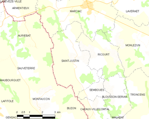
Saint-Justin
- commune in Gers, France
- Country:
- Postal Code: 32230
- Coordinates: 43° 28' 57" N, 0° 9' 4" E
- GPS tracks (wikiloc): [Link]
- Area: 13.18 sq km
- Population: 136

Marciac
- commune in Gers, France
- Country:
- Postal Code: 32230
- Coordinates: 43° 31' 27" N, 0° 9' 42" E
- GPS tracks (wikiloc): [Link]
- Area: 20.6 sq km
- Population: 1247
- Web site: [Link]
Blousson-Sérian
- commune in Gers, France
- Country:
- Postal Code: 32230
- Coordinates: 43° 27' 35" N, 0° 11' 43" E
- GPS tracks (wikiloc): [Link]
- Area: 5.27 sq km
- Population: 43