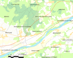
Rigny-Ussé (Rigny-Ussé)

- commune in Indre-et-Loire, France
- Country:

- Postal Code: 37420
- Coordinates: 47° 15' 8" N, 0° 17' 57" E


- GPS tracks (wikiloc): [Link]
- Area: 13.97 sq km
- Population: 494
- Web site: http://www.rigny-usse.fr
- Wikipedia en: wiki(en)
- Wikipedia: wiki(fr)
- Wikidata storage: Wikidata: Q1136519
- Wikipedia Commons Category: [Link]
- Freebase ID: [/m/03nvfhk]
- GeoNames ID: Alt: [6433092]
- SIREN number: [213701972]
- BnF ID: [15257748v]
- VIAF ID: Alt: [146906746]
- Library of Congress authority ID: Alt: [no2001010433]
- PACTOLS thesaurus ID: [pcrtasdsIiyPYU]
- MusicBrainz area ID: [8d70ef75-01da-4b49-b175-8f93bec2754a]
- INSEE municipality code: 37197
Shares border with regions:


Bréhémont
- commune in Indre-et-Loire, France
- Country:
- Postal Code: 37130
- Coordinates: 47° 17' 42" N, 0° 21' 20" E
- GPS tracks (wikiloc): [Link]
- Area: 12.71 sq km
- Population: 776


Saint-Benoît-la-Forêt
- commune in Indre-et-Loire, France
- Country:
- Postal Code: 37500
- Coordinates: 47° 13' 14" N, 0° 19' 21" E
- GPS tracks (wikiloc): [Link]
- Area: 35.25 sq km
- Population: 857
- Web site: [Link]


Huismes
- commune in Indre-et-Loire, France
- Country:
- Postal Code: 37420
- Coordinates: 47° 13' 57" N, 0° 15' 9" E
- GPS tracks (wikiloc): [Link]
- Area: 23.82 sq km
- Population: 1537
- Web site: [Link]

Saint-Patrice
- former commune in Indre-et-Loire, France
- Country:
- Postal Code: 37130
- Coordinates: 47° 17' 11" N, 0° 18' 24" E
- GPS tracks (wikiloc): [Link]
- Area: 17.18 sq km
- Population: 672

Rivarennes
- commune in Indre-et-Loire, France
- Country:
- Postal Code: 37190
- Coordinates: 47° 15' 59" N, 0° 21' 14" E
- GPS tracks (wikiloc): [Link]
- Area: 18.92 sq km
- Population: 1016

La Chapelle-sur-Loire
- commune in Indre-et-Loire, France
- Country:
- Postal Code: 37140
- Coordinates: 47° 14' 55" N, 0° 13' 26" E
- GPS tracks (wikiloc): [Link]
- Area: 19.17 sq km
- Population: 1453
- Web site: [Link]