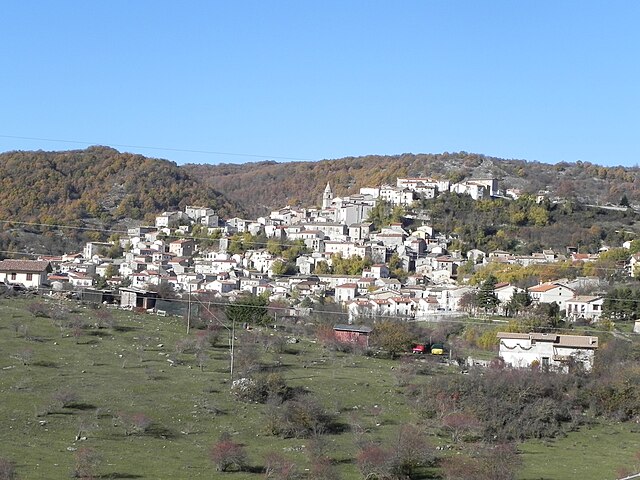
Rionero Sannitico (Rionero Sannitico)
.svg)
- Italian comune
 Hiking in Rionero Sannitico
Rionero Sannitico is a picturesque village located in the Molise region of Italy, surrounded by the stunning landscapes of the Apennine Mountains. Hiking in and around Rionero Sannitico offers a unique opportunity to explore both the natural beauty and the cultural heritage of this lesser-known area.
Hiking Trails
-
Sentiero delle Cime:
- This trail takes you through lush forests, offering breathtaking views of the surrounding mountains. It's a moderate hike, suitable for those with some experience.
-
Monte Marrone:
- This hike leads to the summit of Monte Marrone, providing spectacular panoramic views of the Molise region. The trail can be challenging with steep sections but rewards hikers with stunning sights.
-
Valle del Rio Nocella:
- A beautiful, quieter route alongside a river valley, perfect for nature lovers and families. This trail features diverse flora and fauna and is generally easy to moderate.
-
Parco Nazionale d'Abruzzo, Lazio e Molise:
- Just a short drive from Rionero, this national park offers an extensive network of trails ranging from easy walks to challenging hikes. You can explore beautiful landscapes, wildlife, and historical sites.
Things to Consider
-
Weather: The weather in this region can change rapidly, especially in the mountains, so it’s essential to check forecasts and be prepared for various conditions.
-
Gear: Good hiking shoes, weather-appropriate clothing, and sufficient water and snacks are crucial for a safe and enjoyable hike.
-
Cultural Heritage: Take time to explore the village of Rionero Sannitico itself, with its ancient architecture and local cuisine. Many trails lead to historical landmarks.
-
Wildlife: This region is home to diverse wildlife, including deer, wolves, and numerous bird species. Keep a respectful distance and observe without disturbing.
Safety Tips
- Always let someone know your hiking plans, especially if you’re hiking alone.
- Make sure to carry a map or GPS device, as some trails may not be well-marked.
- Start your hike early to allow plenty of time for exploration and to return before dark.
Hiking in Rionero Sannitico can be a rewarding experience, offering a blend of adventure, tranquility, and cultural enrichment. Enjoy your hiking journey!
- Country:

- Postal Code: 86087
- Local Dialing Code: 0865
- Licence Plate Code: IS
- Coordinates: 41° 43' 0" N, 14° 8' 0" E


- GPS tracks (wikiloc): [Link]
- AboveSeaLevel: 1051 м m
- Area: 29.22 sq km
- Population: 1130
- Web site: http://www.comune.rionerosannitico.is.it/
- Wikipedia en: wiki(en)
- Wikipedia: wiki(it)
- Wikidata storage: Wikidata: Q279530
- Wikipedia Commons Category: [Link]
- Freebase ID: [/m/0gq_t2]
- GeoNames ID: Alt: [6541376]
- OSM relation ID: [41495]
- ISTAT ID: 094039
- Italian cadastre code: H308
Shares border with regions:


Acquaviva d'Isernia
- Italian comune
Hiking in Acquaviva d'Isernia
Acquaviva d'Isernia is a lovely town situated in the Molise region of Italy, surrounded by beautiful landscapes that are ideal for hiking enthusiasts. The area offers a range of trails that cater to different skill levels, allowing hikers to explore its stunning natural beauty, historical sites, and charming villages....
- Country:
- Postal Code: 86080
- Local Dialing Code: 0865
- Licence Plate Code: IS
- Coordinates: 41° 40' 0" N, 14° 9' 0" E
- GPS tracks (wikiloc): [Link]
- AboveSeaLevel: 730 м m
- Area: 13.51 sq km
- Population: 413
- Web site: [Link]


Cerro al Volturno
- Italian comune
Hiking in Cerro al Volturno
Cerro al Volturno is a picturesque area located in the province of Isernia, in the Molise region of Italy. This destination is particularly popular among hikers and nature enthusiasts due to its stunning landscapes, rich biodiversity, and cultural heritage. Here’s what you can expect when hiking in and around Cerro al Volturno:...
- Country:
- Postal Code: 86072
- Local Dialing Code: 0865
- Licence Plate Code: IS
- Coordinates: 41° 39' 0" N, 14° 8' 0" E
- GPS tracks (wikiloc): [Link]
- AboveSeaLevel: 572 м m
- Area: 23.79 sq km
- Population: 1250
- Web site: [Link]

Forlì del Sannio
- Italian comune
Hiking in Forlì del Sannio
Forlì del Sannio is a charming village located in the Molise region of Italy, nestled in the Apennine Mountains. This area is known for its stunning natural landscapes, rich history, and excellent hiking opportunities. Here are some key points to consider if you're planning a hiking trip there:...
- Country:
- Postal Code: 86084
- Local Dialing Code: 0865
- Licence Plate Code: IS
- Coordinates: 41° 42' 0" N, 14° 11' 0" E
- GPS tracks (wikiloc): [Link]
- AboveSeaLevel: 610 м m
- Area: 32.56 sq km
- Population: 683
- Web site: [Link]

Montenero Val Cocchiara
- Italian comune
Hiking in Montenero Val Cocchiara
Montenero Val Cocchiara is a beautiful, lesser-known destination in the Italian region of Molise. Nestled in the Apennine Mountains, it offers a range of hiking opportunities surrounded by stunning natural scenery, quaint villages, and rich history. Here’s what you can expect when hiking in this area:...
- Country:
- Postal Code: 86080
- Local Dialing Code: 0865
- Licence Plate Code: IS
- Coordinates: 41° 43' 0" N, 14° 4' 0" E
- GPS tracks (wikiloc): [Link]
- AboveSeaLevel: 893 м m
- Area: 22.02 sq km
- Population: 514
- Web site: [Link]


Vastogirardi
- Italian comune
Hiking in Vastogirardi
Vastogirardi is a delightful hidden gem located in the Molise region of Italy, known for its stunning landscapes, rich history, and outdoor recreational opportunities. Here are some highlights of hiking in Vastogirardi:...
- Country:
- Postal Code: 86089
- Local Dialing Code: 0865
- Licence Plate Code: IS
- Coordinates: 41° 46' 0" N, 14° 16' 0" E
- GPS tracks (wikiloc): [Link]
- AboveSeaLevel: 1200 м m
- Area: 60.71 sq km
- Population: 684
- Web site: [Link]


Castel di Sangro
- Italian comune
Hiking in Castel di Sangro
Castel di Sangro is located in the Abruzzo region of Italy and is known for its stunning natural landscapes, rich history, and proximity to the Abruzzo, Lazio, and Molise National Park. Hiking in this area offers a variety of trails that cater to different skill levels, making it a great destination for both novice and experienced hikers....
- Country:
- Postal Code: 67031
- Local Dialing Code: 0864
- Licence Plate Code: AQ
- Coordinates: 41° 47' 3" N, 14° 6' 31" E
- GPS tracks (wikiloc): [Link]
- AboveSeaLevel: 805 м m
- Area: 84.44 sq km
- Population: 6705
- Web site: [Link]