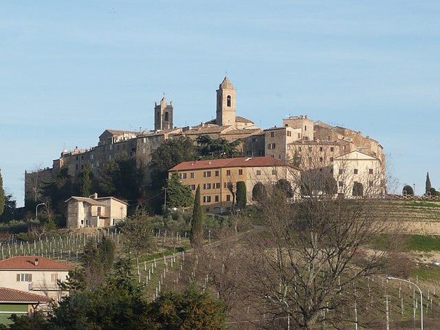
Ripatransone (Ripatransone)
- Italian comune
 Hiking in Ripatransone
Ripatransone, located in the Marche region of Italy, is a charming hilltop town known for its stunning landscapes, historic architecture, and scenic hiking opportunities. Here are some highlights of hiking in and around Ripatransone:
Scenery and Terrain
- Rolling Hills and Vineyards: The surrounding landscape is characterized by gentle rolling hills, patchwork fields, and lush vineyards. The views from the hiking trails offer beautiful panoramas of the Adriatic Sea to the east and the Apennine mountains to the west.
- Historical Sites: As you hike, you might come across ancient stone walls, rural churches, and the remnants of old farmhouses that add a cultural richness to the trails.
Hiking Trails
- Local Trails: There are various local trails suitable for different skill levels. The routes can take you through olive groves, vineyards, and rustic countryside, making it a pleasant experience for nature lovers and hikers.
- The Belvedere Trail: This popular trail offers stunning views of the surrounding countryside and is suitable for a leisurely hike. It leads to viewpoints that overlook the sea and the charming town.
- Camino di Santiago: Parts of the Camino di Santiago pilgrimage route pass nearby, providing an opportunity for more dedicated hikers to explore longer stretches.
Tips for Hiking in Ripatransone
- Best Time to Go: The ideal seasons for hiking are spring and fall when the weather is mild and the landscape is vibrant.
- Equipment: Ensure you have appropriate hiking gear, including sturdy shoes, weather-appropriate clothing, water, and snacks. A map or GPS device can also be helpful.
- Local Advice: Consider visiting the local tourist information center in Ripatransone for maps, current trail conditions, and recommendations on guided hikes.
Safety Considerations
- Trail Conditions: Always check trail conditions before heading out, especially after rain, as some paths may become slippery.
- Wildlife: Be mindful of local wildlife and respect the natural environment during your hikes.
Hiking in Ripatransone provides an excellent way to experience the natural beauty and cultural heritage of the Marche region. Enjoy your adventure!
- Country:

- Postal Code: 63065
- Local Dialing Code: 0735
- Licence Plate Code: AP
- Coordinates: 43° 0' 1" N, 13° 45' 45" E


- GPS tracks (wikiloc): [Link]
- AboveSeaLevel: 494 м m
- Area: 74.28 sq km
- Population: 4232
- Web site: http://www.comune.ripatransone.ap.it/
- Wikipedia en: wiki(en)
- Wikipedia: wiki(it)
- Wikidata storage: Wikidata: Q56086
- Wikipedia Commons Gallery: [Link]
- Wikipedia Commons Category: [Link]
- Freebase ID: [/m/0gl8sh]
- GeoNames ID: Alt: [6536803]
- VIAF ID: Alt: [149195785]
- OSM relation ID: [42255]
- archINFORM location ID: [12598]
- MusicBrainz area ID: [89df65a7-10fe-495a-9750-062700ebd244]
- WOEID: [721729]
- UN/LOCODE: [ITRPE]
- Google Maps Customer ID: [1539439797160387065]
- ISTAT ID: 044063
- Italian cadastre code: H321
Shares border with regions:


Acquaviva Picena
- Italian comune
Hiking in Acquaviva Picena
Acquaviva Picena is a charming village in the Marche region of Italy, nestled in the rolling hills overlooking the Adriatic Sea. While it is often known for its history and beautiful architecture, it also offers some lovely hiking opportunities for outdoor enthusiasts....
- Country:
- Postal Code: 63075
- Local Dialing Code: 0735
- Licence Plate Code: AP
- Coordinates: 42° 56' 41" N, 13° 48' 49" E
- GPS tracks (wikiloc): [Link]
- AboveSeaLevel: 360 м m
- Area: 21.06 sq km
- Population: 3799
- Web site: [Link]


Carassai
- Italian comune
Hiking in Carassai
Carassai, located in the Marche region of Italy, offers a unique hiking experience with its beautiful landscapes, rolling hills, and cultural heritage. While the town itself is relatively small, the surrounding area provides various trails that can cater to different skill levels....
- Country:
- Postal Code: 63063
- Local Dialing Code: 0734
- Licence Plate Code: AP
- Coordinates: 43° 1' 56" N, 13° 41' 1" E
- GPS tracks (wikiloc): [Link]
- AboveSeaLevel: 365 м m
- Area: 22.24 sq km
- Population: 1055
- Web site: [Link]

Cossignano
- Italian comune
Hiking in Cossignano
Cossignano is a charming village located in the Marche region of Italy, known for its scenic landscapes and picturesque countryside. Hiking in and around Cossignano can provide a wonderful experience, blending nature, culture, and stunning views....
- Country:
- Postal Code: 63067
- Local Dialing Code: 0735
- Licence Plate Code: AP
- Coordinates: 42° 59' 2" N, 13° 41' 17" E
- GPS tracks (wikiloc): [Link]
- AboveSeaLevel: 400 м m
- Area: 14.95 sq km
- Population: 952
- Web site: [Link]

Cupra Marittima
- Italian comune
Hiking in Cupra Marittima
Cupra Marittima is a charming town located along the Adriatic coast in the Marche region of Italy. While it's more commonly known for its beautiful beaches and historical sites, the surrounding countryside offers some wonderful hiking opportunities....
- Country:
- Postal Code: 63064
- Local Dialing Code: 0735
- Licence Plate Code: AP
- Coordinates: 43° 1' 30" N, 13° 51' 32" E
- GPS tracks (wikiloc): [Link]
- AboveSeaLevel: 4 м m
- Area: 17.34 sq km
- Population: 5358
- Web site: [Link]
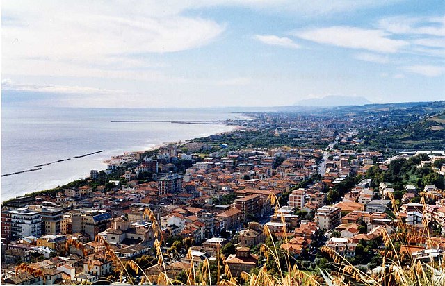

Grottammare
- Italian comune
Hiking in Grottammare
Grottammare is a charming coastal town located along the Adriatic Sea in the Marche region of Italy. While it’s primarily known for its beautiful beaches and vibrant promenade, there are opportunities for hiking and exploring the surrounding landscapes, particularly in the nearby hills and natural reserves....
- Country:
- Postal Code: 63066
- Local Dialing Code: 0735
- Licence Plate Code: AP
- Coordinates: 42° 59' 21" N, 13° 52' 5" E
- GPS tracks (wikiloc): [Link]
- AboveSeaLevel: 4 м m
- Area: 17.66 sq km
- Population: 15286
- Web site: [Link]
Massignano
- Italian comune
Hiking in Massignano
Massignano is a charming village located in the Marche region of Italy, known for its scenic landscapes and hiking opportunities. The area is characterized by rolling hills, vineyards, olive groves, and a beautiful coastline along the Adriatic Sea. Here are some key features and tips for hiking in and around Massignano:...
- Country:
- Postal Code: 63061
- Local Dialing Code: 0735
- Licence Plate Code: AP
- Coordinates: 43° 3' 3" N, 13° 47' 50" E
- GPS tracks (wikiloc): [Link]
- AboveSeaLevel: 255 м m
- Area: 16.3 sq km
- Population: 1640
- Web site: [Link]


Montefiore dell'Aso
- Italian comune
Hiking in Montefiore dell'Aso
Montefiore dell'Aso is a charming hilltop village located in the Marche region of Italy, known for its beautiful landscapes, historical architecture, and a rich cultural heritage. Hiking in and around Montefiore dell'Aso offers a unique blend of natural beauty and cultural exploration....
- Country:
- Postal Code: 63062
- Local Dialing Code: 0734
- Licence Plate Code: AP
- Coordinates: 43° 3' 6" N, 13° 45' 5" E
- GPS tracks (wikiloc): [Link]
- AboveSeaLevel: 412 м m
- Area: 28.21 sq km
- Population: 2053
- Web site: [Link]


Offida
- Italian comune
Hiking in Offida
Offida is a charming medieval town located in the Marche region of Italy, known for its stunning landscape, rich history, and cultural heritage. It sits on a hilltop, offering breathtaking views of the surrounding countryside, making it an excellent destination for hiking enthusiasts....
- Country:
- Postal Code: 63073
- Local Dialing Code: 0736
- Licence Plate Code: AP
- Coordinates: 42° 56' 7" N, 13° 41' 31" E
- GPS tracks (wikiloc): [Link]
- AboveSeaLevel: 293 м m
- Area: 49.6 sq km
- Population: 4962
- Web site: [Link]