
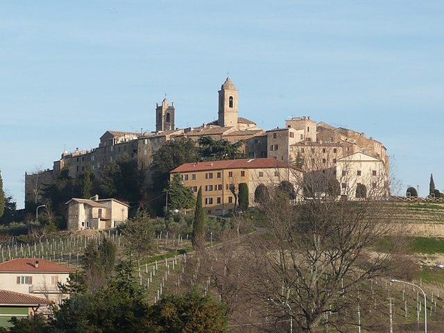
Carassai (Carassai)
.svg)
- Italian comune
 Hiking in Carassai
Carassai, located in the Marche region of Italy, offers a unique hiking experience with its beautiful landscapes, rolling hills, and cultural heritage. While the town itself is relatively small, the surrounding area provides various trails that can cater to different skill levels.
Hiking Highlights in Carassai:
-
Scenic Trails: The region is characterized by picturesque hills, vineyards, and olive groves, making for stunning vistas. Look for paths that take you through the countryside, offering opportunities for photography and nature appreciation.
-
Historical Sites: As you hike, you may come across ancient ruins, castles, and churches that reflect the rich history of the area. The hike can easily be combined with cultural exploration.
-
Wildlife Watching: The natural environment around Carassai is home to diverse flora and fauna. Binoculars may come in handy for birdwatching or spotting other wildlife.
-
Wine Trails: The Marche region is known for its wines, and some hiking routes may take you near vineyards. Consider stopping for a tasting or a picnic amidst the vines.
-
Local Hiking Groups: Check for local hiking clubs or tours that may offer guided hikes, providing you with insights into the area’s natural and cultural heritage.
Tips for Hiking in Carassai:
-
Weather Awareness: Be mindful of the weather conditions, especially in summer when it can get quite hot. Spring and autumn are generally more comfortable for hiking.
-
Trail Maps: Obtain local trail maps or use hiking apps to navigate the various paths. Some trails might not be well-marked, so it's good to stay oriented.
-
Proper Gear: Wear comfortable hiking shoes suitable for uneven terrain, and bring enough water and snacks for your hike.
-
Respect Nature and Culture: Follow the Leave No Trace principles to preserve the natural beauty, and be respectful of local customs and properties.
For the best hiking experience, check local visitor centers or online resources for the latest trail conditions and recommendations. Enjoy your adventure in Carassai!
- Country:

- Postal Code: 63063
- Local Dialing Code: 0734
- Licence Plate Code: AP
- Coordinates: 43° 1' 56" N, 13° 41' 1" E


- GPS tracks (wikiloc): [Link]
- AboveSeaLevel: 365 м m
- Area: 22.24 sq km
- Population: 1055
- Web site: http://www.provincia.ap.it/Carassai/
- Wikipedia en: wiki(en)
- Wikipedia: wiki(it)
- Wikidata storage: Wikidata: Q56035
- Wikipedia Commons Category: [Link]
- Freebase ID: [/m/0gl7nz]
- GeoNames ID: Alt: [6541872]
- VIAF ID: Alt: [124785193]
- OSM relation ID: [42273]
- WOEID: [712204]
- TGN ID: [7043623]
- Google Maps Customer ID: [15423193282706310141]
- ISTAT ID: 044010
- Italian cadastre code: B727
Shares border with regions:

Cossignano
- Italian comune
Hiking in Cossignano
Cossignano is a charming village located in the Marche region of Italy, known for its scenic landscapes and picturesque countryside. Hiking in and around Cossignano can provide a wonderful experience, blending nature, culture, and stunning views....
- Country:
- Postal Code: 63067
- Local Dialing Code: 0735
- Licence Plate Code: AP
- Coordinates: 42° 59' 2" N, 13° 41' 17" E
- GPS tracks (wikiloc): [Link]
- AboveSeaLevel: 400 м m
- Area: 14.95 sq km
- Population: 952
- Web site: [Link]


Montalto delle Marche
- Italian comune
Hiking in Montalto delle Marche
Montalto delle Marche is a beautiful destination for hiking enthusiasts, located in the Marche region of Italy. This area is characterized by its stunning landscapes, rolling hills, and a rich cultural heritage. Here are some key points to consider if you're planning to hike in and around Montalto delle Marche:...
- Country:
- Postal Code: 63068
- Local Dialing Code: 0736
- Licence Plate Code: AP
- Coordinates: 42° 59' 14" N, 13° 36' 25" E
- GPS tracks (wikiloc): [Link]
- AboveSeaLevel: 512 м m
- Area: 33.94 sq km
- Population: 2078
- Web site: [Link]


Montefiore dell'Aso
- Italian comune
Hiking in Montefiore dell'Aso
Montefiore dell'Aso is a charming hilltop village located in the Marche region of Italy, known for its beautiful landscapes, historical architecture, and a rich cultural heritage. Hiking in and around Montefiore dell'Aso offers a unique blend of natural beauty and cultural exploration....
- Country:
- Postal Code: 63062
- Local Dialing Code: 0734
- Licence Plate Code: AP
- Coordinates: 43° 3' 6" N, 13° 45' 5" E
- GPS tracks (wikiloc): [Link]
- AboveSeaLevel: 412 м m
- Area: 28.21 sq km
- Population: 2053
- Web site: [Link]
Ripatransone
- Italian comune
Hiking in Ripatransone
Ripatransone, located in the Marche region of Italy, is a charming hilltop town known for its stunning landscapes, historic architecture, and scenic hiking opportunities. Here are some highlights of hiking in and around Ripatransone:...
- Country:
- Postal Code: 63065
- Local Dialing Code: 0735
- Licence Plate Code: AP
- Coordinates: 43° 0' 1" N, 13° 45' 45" E
- GPS tracks (wikiloc): [Link]
- AboveSeaLevel: 494 м m
- Area: 74.28 sq km
- Population: 4232
- Web site: [Link]


Monte Vidon Combatte
- Italian comune
Hiking in Monte Vidon Combatte
Monte Vidon Combatte is a picturesque area located in the Marche region of Italy, offering a delightful mix of natural beauty, cultural heritage, and outdoor recreation opportunities. Here are some key points to consider for hiking in this area:...
- Country:
- Postal Code: 63847
- Local Dialing Code: 0734
- Licence Plate Code: FM
- Coordinates: 43° 2' 59" N, 13° 37' 49" E
- GPS tracks (wikiloc): [Link]
- AboveSeaLevel: 393 м m
- Area: 11.17 sq km
- Population: 434
- Web site: [Link]


Ortezzano
- Italian comune
Hiking in Ortezzano
Ortezzano is a picturesque village located in the Marche region of Italy. This area offers stunning landscapes, rich cultural heritage, and various hiking opportunities for outdoor enthusiasts. Here are some key points about hiking in and around Ortezzano:...
- Country:
- Postal Code: 63851
- Local Dialing Code: 0734
- Licence Plate Code: FM
- Coordinates: 43° 1' 53" N, 13° 36' 27" E
- GPS tracks (wikiloc): [Link]
- AboveSeaLevel: 301 м m
- Area: 7.08 sq km
- Population: 765
- Web site: [Link]


Petritoli
- Italian comune
Hiking in Petritoli
Petritoli is a charming small town located in the Marche region of Italy, known for its scenic landscapes and historical architecture. Its position on a hill offers stunning views of the surrounding countryside, making it an ideal base for hiking enthusiasts. Here are some key points about hiking in and around Petritoli:...
- Country:
- Postal Code: 63848
- Local Dialing Code: 0734
- Licence Plate Code: FM
- Coordinates: 43° 4' 2" N, 13° 39' 22" E
- GPS tracks (wikiloc): [Link]
- AboveSeaLevel: 358 м m
- Area: 24 sq km
- Population: 2297
- Web site: [Link]