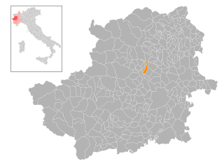
Robassomero (Robassomero)

- Italian comune
 Hiking in Robassomero
Robassomero is a picturesque town located in the Piedmont region of Italy, north of Turin. It's surrounded by beautiful natural landscapes, making it a great destination for hikers and outdoor enthusiasts. Here are some aspects to consider if you're planning a hiking trip to Robassomero:
Hiking Trails
-
Nature Trails: There are various trails ranging from easy walks to more challenging hikes. Many of these paths offer stunning views of the surrounding hills and valleys, especially when the flora is in full bloom.
-
The Chivasso-Robassomero Trail: This route runs through farmland and woodlands. It's a relatively flat path, making it suitable for families and those looking for a leisurely hike.
-
Local Parks: Explore the nearby parks, such as the Parco del Ricetto, which feature several walking paths that showcase the local flora and fauna, ideal for observing wildlife and enjoying the tranquility.
Best Times to Hike
- Spring and Fall: These seasons offer mild weather and beautiful scenery, with blooming flowers in spring and colorful foliage in fall. The temperatures are typically comfortable for hiking.
- Summer: Can be warm, so early morning or late afternoon hikes are recommended to avoid the heat.
- Winter: If you're interested in winter hiking, ensure you have the proper gear, as some trails might be accessible depending on snow conditions.
Preparation Tips
- Physical Fitness: Tailor your hiking plans according to your fitness level. Some trails can be steep or rugged, so assess your capabilities before embarking.
- Gear: Wear comfortable footwear with good traction, and dress in layers to adjust to changing temperatures.
- Safety: Always carry enough water, snacks, a map or GPS, and a first-aid kit. Inform someone of your hiking plans for safety.
Local Culture
Robassomero and the surrounding area offer a glimpse into traditional Piedmontese culture, including local cuisine. After your hike, consider trying local dishes in nearby restaurants or cafes.
Wildlife and Nature
The area around Robassomero is home to diverse wildlife, including various bird species, making it a great spot for birdwatching as well. Keep an eye out for local plants and animals as you hike.
If you plan to hike in the Robassomero area, it's advisable to check local resources for trail conditions, maps, and any guided tours that may be available. Enjoy the stunning scenery and the chance to connect with nature!
- Country:

- Postal Code: 10070
- Local Dialing Code: 011
- Licence Plate Code: TO
- Coordinates: 45° 12' 0" N, 7° 34' 0" E


- GPS tracks (wikiloc): [Link]
- AboveSeaLevel: 360 м m
- Area: 8.58 sq km
- Population: 3089
- Web site: http://www.comune.robassomero.to.it
- Wikipedia en: wiki(en)
- Wikipedia: wiki(it)
- Wikidata storage: Wikidata: Q10232
- Wikipedia Commons Category: [Link]
- Freebase ID: [/m/0g8k_n]
- GeoNames ID: Alt: [6537284]
- OSM relation ID: [44392]
- TGN ID: [7042321]
- UN/LOCODE: [ITRBS]
- ISTAT ID: 001220
- Italian cadastre code: H367
Shares border with regions:
San Maurizio Canavese
- Italian comune
Hiking in San Maurizio Canavese
San Maurizio Canavese is a charming town located in the province of Turin, in the Piedmont region of northern Italy. While it is not particularly famous for its hiking routes, it is situated in a region that offers beautiful landscapes, including the surrounding hills and proximity to the Alps....
- Country:
- Postal Code: 10077
- Local Dialing Code: 011
- Licence Plate Code: TO
- Coordinates: 45° 13' 1" N, 7° 37' 50" E
- GPS tracks (wikiloc): [Link]
- AboveSeaLevel: 317 м m
- Area: 17.34 sq km
- Population: 10312
- Web site: [Link]
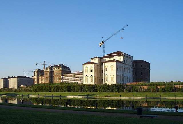

Venaria Reale
- Italian comune
Hiking in Venaria Reale
Venaria Reale, located just outside of Turin, Italy, is best known for the Royal Palace of Venaria, a UNESCO World Heritage site. Though it may not be a traditional hiking destination, the surrounding area offers various outdoor activities, including walking and biking trails that can be enjoyed by hikers of all levels....
- Country:
- Postal Code: 10078
- Local Dialing Code: 011
- Licence Plate Code: TO
- Coordinates: 45° 7' 0" N, 7° 38' 0" E
- GPS tracks (wikiloc): [Link]
- AboveSeaLevel: 262 м m
- Area: 20.44 sq km
- Population: 33781
- Web site: [Link]


Caselle Torinese
- Italian comune
Hiking in Caselle Torinese
Caselle Torinese is a small town located in the Piedmont region of Italy, close to the city of Turin. While it may not be as well-known as some larger hiking destinations, it offers a variety of outdoor activities, including hiking. The surrounding area is characterized by beautiful landscapes, rolling hills, and picturesque views of the surrounding countryside and the Alps....
- Country:
- Postal Code: 10072
- Local Dialing Code: 011
- Licence Plate Code: TO
- Coordinates: 45° 11' 0" N, 7° 39' 0" E
- GPS tracks (wikiloc): [Link]
- AboveSeaLevel: 300 м m
- Area: 23.58 sq km
- Population: 13935
- Web site: [Link]


Cirié
- Italian comune
Hiking in Cirié
Cirié, located in the Piedmont region of Italy, is surrounded by picturesque landscapes and offers a variety of hiking opportunities. Nestled near the foothills of the Alps, hikers can enjoy trails that provide beautiful views, diverse terrains, and a taste of the local flora and fauna....
- Country:
- Postal Code: 10073
- Local Dialing Code: 011
- Licence Plate Code: TO
- Coordinates: 45° 14' 6" N, 7° 35' 56" E
- GPS tracks (wikiloc): [Link]
- AboveSeaLevel: 344 м m
- Area: 17.73 sq km
- Population: 18639
- Web site: [Link]


Druento
- Italian comune
Hiking in Druento
Druento is a charming municipality in the Piedmont region of Italy, known for its proximity to the beautiful natural landscapes of the Susa Valley and the nearby mountains. While it may not be a major hiking destination like some of the surrounding areas, it offers several opportunities for outdoor activities and nature walks....
- Country:
- Postal Code: 10040
- Local Dialing Code: 011
- Licence Plate Code: TO
- Coordinates: 45° 8' 0" N, 7° 35' 0" E
- GPS tracks (wikiloc): [Link]
- AboveSeaLevel: 285 м m
- Area: 27.54 sq km
- Population: 8790
- Web site: [Link]


Fiano
- Italian comune
Hiking in Fiano
Fiano, located in the Piedmont region of Italy, offers a variety of hiking opportunities amidst stunning natural landscapes. Nestled in the foothills of the Alps, this area is characterized by its lush greenery, rolling hills, vineyards, and charming villages....
- Country:
- Postal Code: 10070
- Local Dialing Code: 011
- Licence Plate Code: TO
- Coordinates: 45° 13' 0" N, 7° 31' 0" E
- GPS tracks (wikiloc): [Link]
- AboveSeaLevel: 430 м m
- Area: 12.04 sq km
- Population: 2679
- Web site: [Link]

Nole
- Italian comune
Hiking in Nole
Nole, located in Italy, is surrounded by beautiful natural landscapes that make it an appealing destination for hikers. While specific hiking trails in Nole may not be as widely known as those in larger national parks, there are certainly opportunities to enjoy the picturesque countryside and nearby areas....
- Country:
- Postal Code: 10076
- Local Dialing Code: 011
- Licence Plate Code: TO
- Coordinates: 45° 15' 0" N, 7° 35' 0" E
- GPS tracks (wikiloc): [Link]
- AboveSeaLevel: 356 м m
- Area: 11.35 sq km
- Population: 6895
- Web site: [Link]