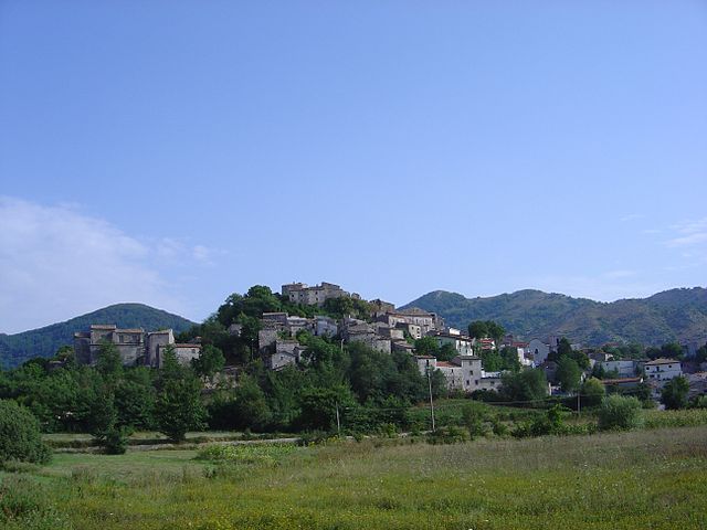
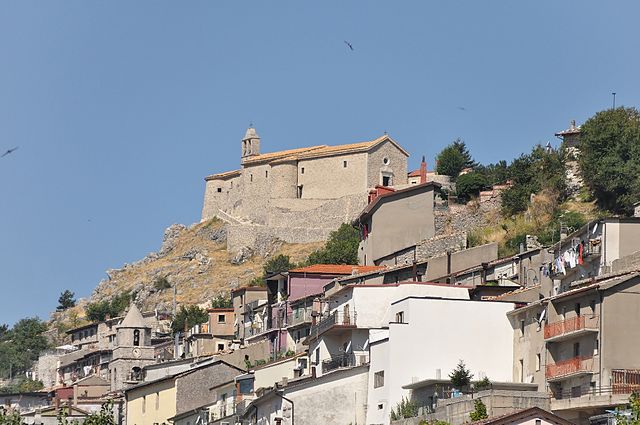
Roccamandolfi (Roccamandolfi)
.svg)
- Italian comune
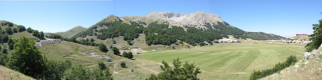
 Hiking in Roccamandolfi
Roccamandolfi, located in the Molise region of Italy, is a fantastic destination for hiking enthusiasts. Nestled in the Apennine Mountains, this area offers a blend of stunning natural landscapes, rich history, and a tranquil environment, making it ideal for both novice and experienced hikers.
Key Highlights for Hiking in Roccamandolfi:
-
Scenic Trails: The region features various trails that range in difficulty and length. Many paths offer breathtaking views of the surrounding mountains, valleys, and traditional Italian villages. The trails are often well-marked, making navigation easier.
-
Natural Beauty: Roccamandolfi is surrounded by lush forests, clear streams, and rocky outcrops. Depending on the season, hikers can enjoy vibrant wildflowers in spring, lush greenery in summer, and stunning autumn foliage.
-
Historical Sites: While hiking, you can encounter several historical landmarks, including ancient ruins and the remains of castles. The area has a rich history that can add an interesting context to your outdoor explorations.
-
Wildlife: The area is home to diverse wildlife, including various bird species, deer, and other native animals. Hiking quietly can provide a chance to observe these creatures in their natural habitat.
-
Local Culture: The town of Roccamandolfi itself provides a glimpse into traditional Italian life. After a day of hiking, you can explore the charming village, enjoy local cuisine, and meet the friendly locals.
-
Seasonal Considerations: The best time for hiking in Roccamandolfi is typically from late spring through early autumn. Be mindful of weather changes, especially in higher elevations, and always check local conditions before heading out.
-
Preparation: As with any hiking adventure, ensure you are well-prepared. Bring appropriate gear, including sturdy hiking boots, weather-appropriate clothing, plenty of water, and snacks. It's also wise to inform someone of your hiking plans or consider going with a group.
Tips for Hiking in Roccamandolfi:
- Start with Easier Trails: If you’re new to hiking or have children with you, start with easier trails until you gauge your comfort level.
- Use Maps or Apps: Make use of hiking apps or physical maps to help navigate the trails. Some local guides may also offer tours.
- Respect Nature: Follow the Leave No Trace principles to preserve the natural beauty of the area.
In summary, hiking in Roccamandolfi offers an enriching experience that combines outdoor adventure with natural beauty and cultural richness. Whether you seek a peaceful day among nature or more challenging climbs, this area has something for every type of hiker.
- Country:

- Postal Code: 86092
- Local Dialing Code: 0865
- Licence Plate Code: IS
- Coordinates: 41° 30' 0" N, 14° 21' 0" E


- GPS tracks (wikiloc): [Link]
- AboveSeaLevel: 850 м m
- Area: 53.67 sq km
- Population: 937
- Web site: http://www.comune.roccamandolfi.is.it
- Wikipedia en: wiki(en)
- Wikipedia: wiki(it)
- Wikidata storage: Wikidata: Q279544
- Wikipedia Commons Category: [Link]
- Freebase ID: [/m/0gq_tg]
- GeoNames ID: Alt: [6541779]
- VIAF ID: Alt: [236605798]
- OSM relation ID: [41307]
- TGN ID: [7042268]
- ISTAT ID: 094040
- Italian cadastre code: H420
Shares border with regions:

San Massimo
- Italian comune
Hiking in San Massimo
San Massimo, located in the Molise region of Italy, is known for its stunning natural landscapes and rich cultural heritage. It offers a variety of hiking opportunities suitable for different skill levels. Here are some key points about hiking in San Massimo:...
- Country:
- Postal Code: 86027
- Local Dialing Code: 0874
- Licence Plate Code: CB
- Coordinates: 41° 29' 0" N, 14° 25' 0" E
- GPS tracks (wikiloc): [Link]
- AboveSeaLevel: 630 м m
- Area: 27.33 sq km
- Population: 873
- Web site: [Link]
Cantalupo nel Sannio
- Italian comune
Hiking in Cantalupo nel Sannio
Cantalupo nel Sannio is a picturesque village located in the Molise region of Italy, known for its natural beauty and rich cultural heritage. Hiking in this area offers a variety of trails that cater to different skill levels, allowing hikers to immerse themselves in the stunning landscapes and enjoy the tranquility of the surrounding nature....
- Country:
- Postal Code: 86092
- Local Dialing Code: 0865
- Licence Plate Code: IS
- Coordinates: 41° 31' 0" N, 14° 24' 0" E
- GPS tracks (wikiloc): [Link]
- AboveSeaLevel: 587 м m
- Area: 15.64 sq km
- Population: 764
- Web site: [Link]
Castelpizzuto
- Italian comune
Hiking in Castelpizzuto
Castelpizzuto is a charming village located in Italy, often overlooked by tourists, making it a hidden gem for hikers and nature lovers. The area is characterized by its stunning landscapes, rich history, and traditional Italian architecture, providing a unique hiking experience....
- Country:
- Postal Code: 86090
- Local Dialing Code: 0865
- Licence Plate Code: IS
- Coordinates: 41° 31' 0" N, 14° 18' 0" E
- GPS tracks (wikiloc): [Link]
- AboveSeaLevel: 836 м m
- Area: 15.39 sq km
- Population: 165
- Web site: [Link]
Longano
- Italian comune
Hiking in Longano
Longano is a charming village located in the province of Isernia, in the Molise region of Italy. Known for its picturesque landscapes and mountainous surroundings, it offers a variety of hiking opportunities for both beginner and experienced hikers....
- Country:
- Postal Code: 86090
- Local Dialing Code: 0865
- Licence Plate Code: IS
- Coordinates: 41° 31' 0" N, 14° 15' 0" E
- GPS tracks (wikiloc): [Link]
- AboveSeaLevel: 700 м m
- Area: 27.38 sq km
- Population: 680
- Web site: [Link]
Santa Maria del Molise
- Italian comune
Hiking in Santa Maria del Molise
Santa Maria del Molise is a small, picturesque village located in the Molise region of Italy, known for its stunning natural landscapes and rich cultural heritage. The surrounding area offers a variety of hiking opportunities suitable for different skill levels, making it a great destination for outdoor enthusiasts....
- Country:
- Postal Code: 86090
- Local Dialing Code: 0865
- Licence Plate Code: IS
- Coordinates: 41° 33' 0" N, 14° 22' 0" E
- GPS tracks (wikiloc): [Link]
- AboveSeaLevel: 587 м m
- Area: 17.2 sq km
- Population: 675
- Web site: [Link]
Gallo Matese
- Italian comune
Hiking in Gallo Matese
Gallo Matese is a beautiful area in the Campania region of Italy, known for its stunning natural landscapes and rich biodiversity. Located in the Matese Regional Park, it offers a variety of hiking trails that cater to different skill levels, from easy walks to more challenging treks....
- Country:
- Postal Code: 81010
- Local Dialing Code: 0823
- Licence Plate Code: CE
- Coordinates: 41° 28' 0" N, 14° 13' 0" E
- GPS tracks (wikiloc): [Link]
- AboveSeaLevel: 875 м m
- Area: 31.13 sq km
- Population: 537
- Web site: [Link]
Letino
- Italian comune
Hiking in Letino
Letino is a charming village located in the Campania region of Italy, surrounded by beautiful natural landscapes, making it a great location for hiking enthusiasts. Nestled in the hills of the Matese Regional Park, Letino offers a variety of trails that cater to different skill levels, from easy walks to more challenging hikes....
- Country:
- Postal Code: 81010
- Local Dialing Code: 0823
- Licence Plate Code: CE
- Coordinates: 41° 27' 0" N, 14° 15' 0" E
- GPS tracks (wikiloc): [Link]
- AboveSeaLevel: 1050 м m
- Area: 31.59 sq km
- Population: 703
- Web site: [Link]

San Gregorio Matese
- Italian comune
Hiking in San Gregorio Matese
San Gregorio Matese is a picturesque village located in the Campania region of Italy, nestled in the Matese mountain range. This area is known for its stunning natural beauty, offering a variety of hiking opportunities that cater to different skill levels. Here are some highlights and recommendations for hiking in San Gregorio Matese:...
- Country:
- Postal Code: 81010
- Local Dialing Code: 0823
- Licence Plate Code: CE
- Coordinates: 41° 23' 0" N, 14° 22' 0" E
- GPS tracks (wikiloc): [Link]
- AboveSeaLevel: 765 м m
- Area: 56.51 sq km
- Population: 946
- Web site: [Link]