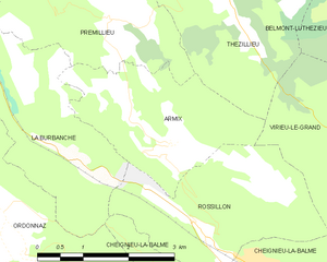
Rossillon (Rossillon)
- commune in Ain, France
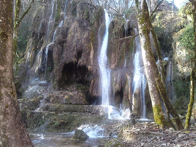
 Hiking in Rossillon
Rossillon is a charming village located in the region of Provence in southeastern France. While it’s not as well-known as some of the more prominent hiking destinations in the region, it offers beautiful landscapes and a more tranquil hiking experience. Here’s what you can expect when hiking in and around Rossillon:
Scenic Trails
- Stunning Views: The trails around Rossillon often feature breathtaking views of the lavender fields, vineyards, and the iconic ochre cliffs that the region is known for.
- Varied Terrain: The hiking paths can range from easy walks to more challenging routes, suitable for all levels of hikers.
Notable Hikes
- Ochre Trail: Often considered one of the highlights, this trail leads through the ochre quarries of Roussillon, offering a unique landscape colored in shades of red and yellow. It’s a well-marked trail that is accessible to most hikers.
- Sentier des Ocres: This is a loop trail located in the Conservatoire des Ocres et de la Couleur. It takes you through stunning ochre landscapes and offers interpretive signs about the geology and history of the area.
- Nearby Villages: Consider extending your hike to include visits to nearby villages like Gordes or Bonnieux, which can add to your hiking experience with their picturesque streets and local culture.
Tips for Hiking in Rossillon
- Best Time to Go: Spring and early fall are ideal times to hike in Rossillon, as the weather is generally mild and the fields are in full bloom.
- Stay Hydrated: Carry plenty of water, especially on warmer days, as some trails might lack shade.
- Footwear: Proper hiking shoes are essential, as some trails can be rocky or uneven.
- Local Culture: After your hike, take the opportunity to explore the village, enjoy local cuisine, and visit art galleries that showcase regional artists.
Safety Considerations
- Always check the weather forecast before setting out.
- Notify someone of your hiking plans, especially if you’re hiking solo.
- Carry a map or a GPS device, as some trails may not always be well-marked.
Hiking in Rossillon offers a fantastic way to connect with nature while also experiencing the charm and beauty of Provence. Enjoy your adventure!
- Country:

- Postal Code: 01510
- Coordinates: 45° 49' 55" N, 5° 35' 37" E


- GPS tracks (wikiloc): [Link]
- Area: 8.07 sq km
- Population: 150
- Wikipedia en: wiki(en)
- Wikipedia: wiki(fr)
- Wikidata storage: Wikidata: Q848996
- Wikipedia Commons Category: [Link]
- Wikipedia Commons Maps Category: [Link]
- Freebase ID: [/m/081nc3]
- Freebase ID: [/m/081nc3]
- Freebase ID: [/m/081nc3]
- GeoNames ID: Alt: [6424646]
- GeoNames ID: Alt: [6424646]
- GeoNames ID: Alt: [6424646]
- SIREN number: [210103297]
- SIREN number: [210103297]
- SIREN number: [210103297]
- INSEE municipality code: 01329
- INSEE municipality code: 01329
- INSEE municipality code: 01329
Shares border with regions:

Armix
- commune in Ain, France
Hiking in Armix
It seems there may be a misunderstanding, as "Armix" is not widely recognized as a specific hiking destination or region in most hiking literature or databases. However, it's possible that you may be referring to a local area, park, or a lesser-known trail....
- Country:
- Postal Code: 01510
- Coordinates: 45° 50' 57" N, 5° 35' 8" E
- GPS tracks (wikiloc): [Link]
- Area: 6.82 sq km
- Population: 24
Virieu-le-Grand
- commune in Ain, France
Hiking in Virieu-le-Grand
Virieu-le-Grand is a charming village located in the Auvergne-Rhône-Alpes region of France, nestled between beautiful natural landscapes, making it a great destination for hiking enthusiasts. The area offers several hiking trails that vary in difficulty, catering to both beginners and experienced hikers....
- Country:
- Postal Code: 01510
- Coordinates: 45° 50' 57" N, 5° 39' 6" E
- GPS tracks (wikiloc): [Link]
- Area: 12.55 sq km
- Population: 1067
- Web site: [Link]

Cheignieu-la-Balme
- commune in Ain, France
Hiking in Cheignieu-la-Balme
Cheignieu-la-Balme is a charming commune located in the Ain department of the Auvergne-Rhône-Alpes region in southeastern France. The area is known for its picturesque landscapes, rolling hills, forests, and proximity to the Rhône River, making it a wonderful place for hiking enthusiasts....
- Country:
- Postal Code: 01510
- Coordinates: 45° 49' 38" N, 5° 36' 28" E
- GPS tracks (wikiloc): [Link]
- Area: 6.26 sq km
- Population: 139

La Burbanche
- commune in Ain, France
Hiking in La Burbanche
La Burbanche is a picturesque mountainous region located in the Rhône-Alpes area of France, known for its beautiful landscapes, scenic views, and hiking opportunities. It is situated near the Chartreuse Mountains and offers a variety of trails suitable for different skill levels, making it an excellent destination for hikers....
- Country:
- Postal Code: 01510
- Coordinates: 45° 50' 48" N, 5° 33' 38" E
- GPS tracks (wikiloc): [Link]
- Area: 10.82 sq km
- Population: 71