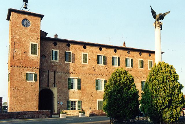
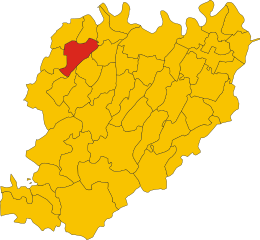
Rottofreno (Rottofreno)
.svg)
- Italian comune
 Hiking in Rottofreno
Rottofreno is a small municipality in the province of Piacenza, located in the Emilia-Romagna region of Northern Italy. While it's not as widely known for its hiking routes as larger national parks or mountainous areas, there are still opportunities for scenic walks and hikes in and around Rottofreno.
Hiking Opportunities in Rottofreno:
-
Local Trails: The countryside surrounding Rottofreno features a mix of agricultural landscape, vineyards, and woodlands. You can find various local walking and biking paths that offer beautiful views of the rolling hills typical of the Piacenza region.
-
Parco del Trebbia: Nearby, you can explore the Trebbia River, known for its clear waters and picturesque landscapes. There are trails along the riverbank and in the surrounding areas that allow for pleasant hikes and nature walks.
-
Historical Routes: Hiking in this region can also be a cultural experience, with trails leading to historical sites and rural churches. The architecture and local history add a unique dimension to your hikes.
-
Vineyard Tours: The area is known for its wine production. Some hiking routes can be combined with vineyard tours, where you can explore the local wineries and enjoy wine tasting.
-
Seasonal Considerations: Depending on the time of year, be cautious of the weather and trail conditions. Spring and fall are particularly pleasant for hiking, while summer can become hot.
Tips for Hiking in Rottofreno:
- Preparation: Always check local maps and guides for detailed trail information. Ensure you wear appropriate footwear and bring enough water and snacks.
- Guided Tours: If you are unfamiliar with the area, consider joining a guided hike. Local guides often have invaluable information about the flora, fauna, and history of the region.
- Wildlife Watching: Keep an eye out for local wildlife. The region is home to a variety of birds and small mammals, making it a fantastic spot for nature enthusiasts.
Whether you're looking for a casual stroll or a more strenuous hike, Rottofreno offers a charming escape into the Italian countryside. Happy hiking!
- Country:

- Postal Code: 29010
- Local Dialing Code: 0523
- Licence Plate Code: PC
- Coordinates: 45° 3' 29" N, 9° 32' 56" E


- GPS tracks (wikiloc): [Link]
- AboveSeaLevel: 65 м m
- Area: 35.17 sq km
- Population: 12220
- Web site: http://www.comune.rottofreno.pc.it
- Wikipedia en: wiki(en)
- Wikipedia: wiki(it)
- Wikidata storage: Wikidata: Q102965
- Wikipedia Commons Category: [Link]
- Freebase ID: [/m/0gkd5g]
- GeoNames ID: Alt: [6541631]
- VIAF ID: Alt: [240121983]
- OSM relation ID: [44060]
- UN/LOCODE: [ITRFO]
- ISTAT ID: 033039
- Italian cadastre code: H593
Shares border with regions:
Borgonovo Val Tidone
- Italian comune
Hiking in Borgonovo Val Tidone
Borgonovo Val Tidone is a charming town located in the Piacenza province of Emilia-Romagna in Italy, nestled in the beautiful Tidone Valley. The region is known for its picturesque landscapes, rolling hills, vineyards, and rich history, making it a fantastic destination for hiking enthusiasts....
- Country:
- Postal Code: 29011
- Local Dialing Code: 0523
- Licence Plate Code: PC
- Coordinates: 45° 1' 0" N, 9° 27' 0" E
- GPS tracks (wikiloc): [Link]
- AboveSeaLevel: 114 м m
- Area: 51.22 sq km
- Population: 7952
- Web site: [Link]


Calendasco
- Italian comune
Hiking in Calendasco
Calendasco is a small town located in the Emilia-Romagna region of Italy, near the city of Piacenza. While it may not be a famous hiking destination, the surrounding area offers some opportunities for outdoor enthusiasts to explore nature....
- Country:
- Postal Code: 29010
- Local Dialing Code: 0523
- Licence Plate Code: PC
- Coordinates: 45° 5' 0" N, 9° 36' 0" E
- GPS tracks (wikiloc): [Link]
- AboveSeaLevel: 55 м m
- Area: 36.94 sq km
- Population: 2459
- Web site: [Link]


Gragnano Trebbiense
- Italian comune
Hiking in Gragnano Trebbiense
Gragnano Trebbiense is a charming village located in the province of Piacenza in Italy. The surrounding area offers beautiful landscapes, rolling hills, and a mix of natural beauty and cultural heritage, making it an excellent destination for hiking enthusiasts....
- Country:
- Postal Code: 29010
- Local Dialing Code: 0523
- Licence Plate Code: PC
- Coordinates: 45° 1' 0" N, 9° 34' 0" E
- GPS tracks (wikiloc): [Link]
- AboveSeaLevel: 82 м m
- Area: 34.61 sq km
- Population: 4600
- Web site: [Link]


Sarmato
- Italian comune
Hiking in Sarmato
Sarmato is a small town located in the Emilia-Romagna region of Italy, and while it may not be a well-known hiking destination, there are opportunities for walking and exploring the surrounding countryside. Here are some suggestions for hiking in and around Sarmato:...
- Country:
- Postal Code: 29010
- Local Dialing Code: 0523
- Licence Plate Code: PC
- Coordinates: 45° 4' 0" N, 9° 29' 0" E
- GPS tracks (wikiloc): [Link]
- AboveSeaLevel: 74 м m
- Area: 27.26 sq km
- Population: 2845
- Web site: [Link]


Piacenza
- Italian comune
Hiking in Piacenza
Hiking in Piacenza, Italy, offers a diverse range of trails and scenic landscapes that cater to hikers of all skill levels. Piacenza is situated at the edge of the Po River valley and is surrounded by the Apennine Mountains, providing plenty of opportunities for both easy walks and challenging hikes....
- Country:
- Postal Code: 29121–29122
- Local Dialing Code: 0523
- Licence Plate Code: PC
- Coordinates: 45° 3' 0" N, 9° 42' 0" E
- GPS tracks (wikiloc): [Link]
- AboveSeaLevel: 61 м m
- Area: 118.24 sq km
- Population: 102355
- Web site: [Link]
Monticelli Pavese
- Italian comune
Hiking in Monticelli Pavese
Monticelli Pavese, located in the Lombardy region of northern Italy, offers a beautiful backdrop for hikers seeking to explore the stunning Italian countryside. The terrain is characterized by rolling hills, vineyards, and charming small villages, making it perfect for both casual walkers and more serious hikers....
- Country:
- Postal Code: 27010
- Local Dialing Code: 0382
- Licence Plate Code: PV
- Coordinates: 45° 7' 0" N, 9° 31' 0" E
- GPS tracks (wikiloc): [Link]
- AboveSeaLevel: 53 м m
- Area: 20.19 sq km
- Population: 737
- Web site: [Link]


Chignolo Po
- Italian comune
Hiking in Chignolo Po
Chignolo Po is a small town located in the Lombardy region of Italy, known more for its agricultural landscape than for traditional hiking trails. However, its proximity to larger regions with hiking opportunities makes it a good starting point for exploring the beautiful Italian countryside....
- Country:
- Postal Code: 27013
- Local Dialing Code: 0382
- Licence Plate Code: PV
- Coordinates: 45° 9' 0" N, 9° 29' 0" E
- GPS tracks (wikiloc): [Link]
- AboveSeaLevel: 88 м m
- Area: 23.39 sq km
- Population: 3982
- Web site: [Link]