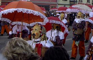
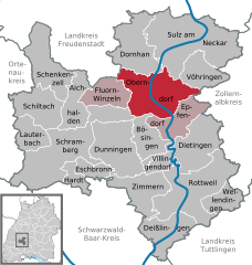
Rottweil (Landkreis Rottweil)

- district of Baden-Württemberg, Germany
 Hiking in Rottweil
Rottweil, located in the Baden-Württemberg region of Germany, offers a range of hiking opportunities that cater to various skill levels. The district boasts beautiful landscapes, including forests, hills, and rivers, along with rich historical sites. Here are some highlights for hikers in the area:
1.
- Black Forest Pathways: While not directly in Rottweil, the Black Forest is nearby and offers numerous trails with stunning views, dense woods, and diverse flora and fauna.
- The Neckar River Valley: Hiking along parts of the Neckar offers scenic views, quaint villages, and a chance to experience the region’s culture.
- The Swabian Jura: This region features unique limestone cliffs and great viewpoints, ideal for more experienced hikers.
2.
- Rottweil Old Town: Take breaks in the historic old town, which showcases medieval architecture, including the Rottweiler Tower and the town’s various churches.
- The Town’s Historic Significance: As one of the oldest towns in Germany, Rottweil has a rich history that can be explored through guided walking tours or by visiting local museums.
3.
Rottweil offers trails of varying difficulty, from easy walks suitable for families to more challenging hikes for seasoned adventurers. Be sure to check trail markers and maps for guidance.
4.
- Spring and Autumn: These seasons are ideal for hiking, with moderate temperatures and beautiful natural displays. Spring brings blooms, while fall showcases vibrant foliage.
- Summer: Warmer weather is pleasant, but it can get crowded, especially on popular trails.
5.
- Gear: Ensure you have the appropriate hiking gear, including sturdy shoes, weather-appropriate clothing, and a reliable backpack.
- Navigation: Use trail maps or a reliable hiking app to stay on course.
- Local Advice: Consider checking in at local visitor centers for trail recommendations and current conditions.
6.
Enhance your hike by experiencing local cuisine or visiting a winery along the way, as the area is known for its vineyards and traditional Swabian dishes.
Overall, Rottweil offers a unique hiking experience combining natural beauty and cultural exploration, making it a great destination for outdoor enthusiasts.
- Country:

- Capital: Rottweil
- Licence Plate Code: RW
- Coordinates: 48° 10' 12" N, 8° 37' 48" E


- GPS tracks (wikiloc): [Link]
- AboveSeaLevel: 667 м m
- Area: 769.48 sq km
- Population: 135553
- Web site: http://www.breisgau-hochschwarzwald.de/
- Wikipedia en: wiki(en)
- Wikipedia: wiki(de)
- Wikidata storage: Wikidata: Q8211
- Wikipedia Commons Category: [Link]
- Freebase ID: [/m/01l1my]
- GeoNames ID: Alt: [3214110]
- VIAF ID: Alt: [130219310]
- OSM relation ID: [62344]
- GND ID: Alt: [4050743-9]
- archINFORM location ID: [2591]
- Library of Congress authority ID: Alt: [n83012834]
- TGN ID: [7075012]
- NUTS code: [DE135]
- German district key: 08325
Includes regions:

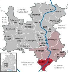
Deißlingen
- municipality in Germany
Hiking in Deißlingen
Deißlingen, located in the state of Baden-Württemberg, Germany, is surrounded by beautiful natural landscapes that offer great hiking opportunities. The region is characterized by rolling hills, lush forests, and scenic vistas, making it an inviting destination for both casual hikers and more experienced outdoor enthusiasts....
- Country:
- Postal Code: 78628; 78652
- Local Dialing Code: 07420
- Licence Plate Code: RW
- Coordinates: 48° 6' 44" N, 8° 36' 26" E
- GPS tracks (wikiloc): [Link]
- AboveSeaLevel: 611 м m
- Area: 32.15 sq km
- Population: 5961
- Web site: [Link]
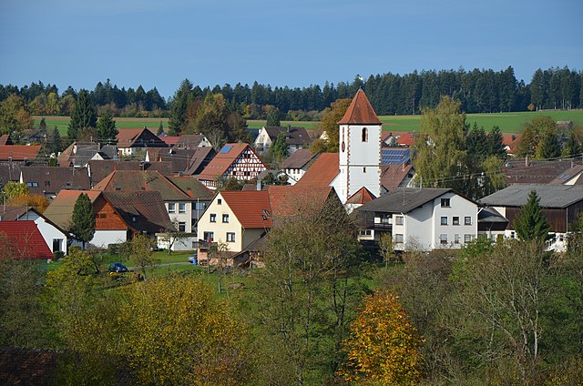
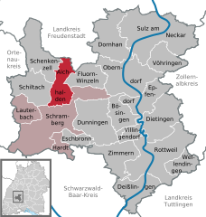
Fluorn-Winzeln
- municipality in Germany
Hiking in Fluorn-Winzeln
Fluorn-Winzeln is a charming village located in the scenic region of the Black Forest in Germany. This area offers a variety of hiking trails that cater to different skill levels, making it a great destination for both novice and experienced hikers....
- Country:
- Postal Code: 78737
- Local Dialing Code: 07402
- Licence Plate Code: RW
- Coordinates: 48° 17' 53" N, 8° 29' 27" E
- GPS tracks (wikiloc): [Link]
- AboveSeaLevel: 649 м m
- Area: 24.6 sq km
- Population: 3094
- Web site: [Link]

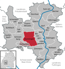
Dunningen
- municipality in Germany
Hiking in Dunningen
Dunningen is a picturesque municipality located in the Baden-Württemberg region of Germany, known for its beautiful natural landscapes, rolling hills, and dense forests, making it an excellent destination for hikers and outdoor enthusiasts....
- Country:
- Postal Code: 78713; 78655
- Local Dialing Code: 07402; 07403
- Licence Plate Code: RW
- Coordinates: 48° 12' 45" N, 8° 30' 22" E
- GPS tracks (wikiloc): [Link]
- AboveSeaLevel: 659 м m
- Area: 48.44 sq km
- Population: 6227
- Web site: [Link]


Zimmern ob Rottweil
- municipality in Germany
Hiking in Zimmern ob Rottweil
Zimmern ob Rottweil is a small town in Baden-Württemberg, Germany, located near the Black Forest region, which is known for its beautiful landscapes and ample hiking opportunities. Here are some highlights and tips for hiking in and around Zimmern ob Rottweil:...
- Country:
- Postal Code: 78658
- Local Dialing Code: 0741
- Licence Plate Code: RW
- Coordinates: 48° 10' 0" N, 8° 35' 40" E
- GPS tracks (wikiloc): [Link]
- AboveSeaLevel: 663 м m
- Area: 33.76 sq km
- Population: 6149
- Web site: [Link]

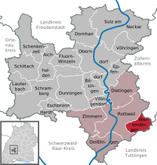
Wellendingen
- municipality in Germany
Hiking in Wellendingen
Wellendingen is a small town in the district of Tuttlingen in Baden-Württemberg, Germany. Nestled in the scenic Swabian Jura region, it offers a variety of hiking opportunities suited for nature enthusiasts of all levels. Here are some key points you might find helpful when hiking in Wellendingen:...
- Country:
- Postal Code: 78669
- Local Dialing Code: 07426
- Licence Plate Code: RW
- Coordinates: 48° 8' 51" N, 8° 42' 13" E
- GPS tracks (wikiloc): [Link]
- AboveSeaLevel: 638 м m
- Area: 17.47 sq km
- Population: 3164
- Web site: [Link]

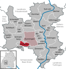
Eschbronn
- municipality in Germany
Hiking in Eschbronn
Eschbronn is a charming village located in the Black Forest region of Germany, known for its picturesque landscapes, dense forests, and scenic hiking trails. Hiking in this area offers a fantastic opportunity to immerse yourself in nature, explore diverse terrains, and enjoy the beautiful views the Black Forest is famous for....
- Country:
- Postal Code: 78664
- Local Dialing Code: 07403
- Licence Plate Code: RW
- Coordinates: 48° 11' 6" N, 8° 27' 28" E
- GPS tracks (wikiloc): [Link]
- AboveSeaLevel: 700 м m
- Area: 11.41 sq km
- Population: 2076
- Web site: [Link]


Epfendorf
- municipality in Germany
Hiking in Epfendorf
Epfendorf is a charming village located in the state of Baden-Württemberg, Germany, and is surrounded by beautiful landscapes that are ideal for hiking enthusiasts. Here are some highlights you might find interesting about hiking in and around Epfendorf:...
- Country:
- Postal Code: 78736
- Local Dialing Code: 07404
- Licence Plate Code: RW
- Coordinates: 48° 15' 0" N, 8° 36' 0" E
- GPS tracks (wikiloc): [Link]
- AboveSeaLevel: 482 м m
- Area: 29.71 sq km
- Population: 3310
- Web site: [Link]
Vöhringen
- municipality in the district of Rottweil, Baden-Württemberg, Germany
Hiking in Vöhringen
Vöhringen, located in Baden-Württemberg, Germany, is a charming town that serves as a great starting point for various hiking adventures. While Vöhringen itself is relatively small, its location in the beautiful region of Swabia provides access to several picturesque trails and natural landscapes....
- Country:
- Postal Code: 72189
- Local Dialing Code: 07454
- Licence Plate Code: RW
- Coordinates: 48° 20' 3" N, 8° 39' 50" E
- GPS tracks (wikiloc): [Link]
- AboveSeaLevel: 506 м m
- Area: 24.72 sq km
- Population: 4313
- Web site: [Link]


Schenkenzell
- municipality in Germany
Hiking in Schenkenzell
Schenkenzell, located in the scenic Black Forest region of Germany, is a great destination for hiking enthusiasts. The area is characterized by lush forests, rolling hills, and picturesque valleys, making it an ideal place to explore nature....
- Country:
- Postal Code: 77773
- Local Dialing Code: 07836
- Coordinates: 48° 18' 0" N, 8° 22' 0" E
- GPS tracks (wikiloc): [Link]
- AboveSeaLevel: 343 м m
- Area: 42.14 sq km
- Population: 1764
- Web site: [Link]
Bösingen
- municipality in Germany
Hiking in Bösingen
Bösingen is a picturesque village located in the district of Freudenstadt in Baden-Württemberg, Germany. The surrounding region offers various hiking opportunities, making it a great destination for outdoor enthusiasts. Here are some highlights of hiking in and around Bösingen:...
- Country:
- Postal Code: 78662
- Local Dialing Code: 07404
- Licence Plate Code: RW
- Coordinates: 48° 14' 21" N, 8° 33' 29" E
- GPS tracks (wikiloc): [Link]
- AboveSeaLevel: 580 м m
- Area: 22.45 sq km
- Population: 3323
- Web site: [Link]


Lauterbach
- municipality in Germany
Hiking in Lauterbach
Lauterbach, located in the state of Baden-Württemberg, Germany, is a charming place for outdoor enthusiasts and hikers alike. Nestled in the scenic countryside, Lauterbach offers a variety of trails that showcase the region's natural beauty, including forests, hills, and meadows....
- Country:
- Postal Code: 78730
- Local Dialing Code: 07422
- Licence Plate Code: RW
- Coordinates: 48° 13' 43" N, 8° 20' 37" E
- GPS tracks (wikiloc): [Link]
- AboveSeaLevel: 579 м m
- Area: 19.97 sq km
- Population: 2888
- Web site: [Link]
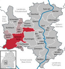
Schramberg
- municipality in Germany
Hiking in Schramberg
Schramberg, located in the Black Forest region of Germany, is a great destination for hikers due to its diverse landscapes, rich natural beauty, and well-maintained trails. Here are some key points and recommendations for hiking in Schramberg:...
- Country:
- Postal Code: 78713; 78144
- Local Dialing Code: 07422
- Licence Plate Code: RW
- Coordinates: 48° 13' 37" N, 8° 23' 3" E
- GPS tracks (wikiloc): [Link]
- AboveSeaLevel: 424 м m
- Area: 80.7 sq km
- Population: 20985
- Web site: [Link]


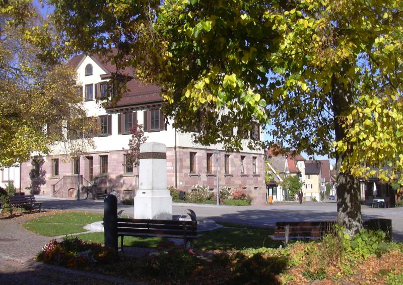
Rottweil
- town in the District of Rottweil, Baden-Württemberg, Germany
Hiking in Rottweil
Rottweil, located in the Baden-Württemberg region of Germany, offers a variety of hiking opportunities surrounded by stunning landscapes and rich history. The area is known for its picturesque charms, including rolling hills, vineyards, and the scenic Black Forest nearby. Here are a few highlights for hiking in Rottweil:...
- Country:
- Postal Code: 78611–78628
- Local Dialing Code: 0741
- Licence Plate Code: RW
- Coordinates: 48° 10' 5" N, 8° 37' 29" E
- GPS tracks (wikiloc): [Link]
- AboveSeaLevel: 599 м m
- Area: 71.76 sq km
- Population: 25204
- Web site: [Link]


Schiltach
- municipality in Germany
Hiking in Schiltach
Schiltach is a picturesque town located in the Black Forest region of Germany, known for its charming half-timbered houses and beautiful natural surroundings. Hiking in and around Schiltach offers a great opportunity to explore the stunning landscapes of the Black Forest, which features dense forests, rolling hills, and scenic valleys....
- Country:
- Postal Code: 77757–77761
- Local Dialing Code: 07836
- Coordinates: 48° 17' 26" N, 8° 20' 41" E
- GPS tracks (wikiloc): [Link]
- AboveSeaLevel: 330 м m
- Area: 34.22 sq km
- Population: 3789
- Web site: [Link]


Hardt
- municipality in Baden-Württemberg, Germany
Hiking in Hardt
Hiking in Hardt, located in Baden-Württemberg, offers a wonderful experience for nature lovers and outdoor enthusiasts. The region is known for its picturesque landscapes, lush forests, and charming village atmosphere. Here are some key points to consider when planning a hike in Hardt:...
- Country:
- Postal Code: 78739
- Local Dialing Code: 07422
- Licence Plate Code: RW
- Coordinates: 48° 11' 2" N, 8° 24' 41" E
- GPS tracks (wikiloc): [Link]
- AboveSeaLevel: 785 м m
- Area: 10.61 sq km
- Population: 2517
- Web site: [Link]

Dietingen
- municipality in Germany
Hiking in Dietingen
Dietingen is located in the beautiful area of Baden-Württemberg, Germany, which offers diverse hiking opportunities for outdoor enthusiasts. The surrounding region features scenic landscapes, including rolling hills, lush forests, and picturesque views, making it an attractive destination for hikers of all skill levels....
- Country:
- Postal Code: 78661
- Local Dialing Code: 07404; 0741
- Licence Plate Code: RW
- Coordinates: 48° 12' 20" N, 8° 38' 46" E
- GPS tracks (wikiloc): [Link]
- AboveSeaLevel: 574 м m
- Area: 42.26 sq km
- Population: 3958
- Web site: [Link]
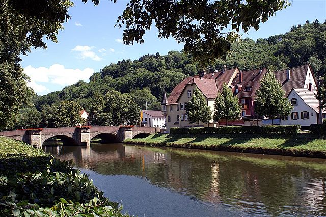
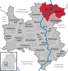
Sulz am Neckar
- municipality in Germany
Hiking in Sulz am Neckar
Sulz am Neckar is a charming town in the Baden-Württemberg region of Germany, situated along the scenic Neckar River. The surrounding area offers a variety of hiking opportunities that cater to all levels of experience, allowing hikers to enjoy both natural beauty and cultural sites....
- Country:
- Postal Code: 72168–72172
- Local Dialing Code: 07454
- Licence Plate Code: RW
- Coordinates: 48° 21' 46" N, 8° 37' 54" E
- GPS tracks (wikiloc): [Link]
- AboveSeaLevel: 443 м m
- Area: 87.60 sq km
- Population: 12267
- Web site: [Link]
Oberndorf am Neckar
- municipality in Germany
Hiking in Oberndorf am Neckar
Oberndorf am Neckar is a charming town located in Baden-Württemberg, Germany, nestled along the Neckar River. The region is known for its picturesque landscapes, which include lush forests, rolling hills, and scenic river views, making it an excellent destination for hiking enthusiasts....
- Country:
- Postal Code: 78727
- Local Dialing Code: 07423
- Licence Plate Code: RW
- Coordinates: 48° 17' 29" N, 8° 34' 21" E
- GPS tracks (wikiloc): [Link]
- AboveSeaLevel: 506 м m
- Area: 55.93 sq km
- Population: 13682
- Web site: [Link]
Villingendorf
- municipality in Germany
Hiking in Villingendorf
Villingendorf is a charming village located in the state of Baden-Württemberg, Germany. While it may not be as widely known as some major hiking destinations, it offers access to some beautiful trails and scenic surroundings typical of the region's rolling hills, forests, and agricultural landscapes....
- Country:
- Postal Code: 78667
- Local Dialing Code: 0741
- Licence Plate Code: RW
- Coordinates: 48° 12' 0" N, 8° 35' 0" E
- GPS tracks (wikiloc): [Link]
- AboveSeaLevel: 640 м m
- Area: 9.33 sq km
- Population: 3265
- Web site: [Link]
Aichhalden
- municipality in Germany
Hiking in Aichhalden
Aichhalden, located in the picturesque region of Baden-Württemberg, Germany, offers beautiful hiking opportunities for outdoor enthusiasts. The area is characterized by scenic landscapes, including rolling hills, lush forests, and charming villages, making it an attractive destination for both casual walkers and serious hikers....
- Country:
- Postal Code: 78733
- Local Dialing Code: 07836; 07444; 07422
- Licence Plate Code: RW
- Coordinates: 48° 16' 0" N, 8° 25' 0" E
- GPS tracks (wikiloc): [Link]
- AboveSeaLevel: 684 м m
- Area: 25.74 sq km
- Population: 3988
- Web site: [Link]

Dornhan
- municipality in Germany
Hiking in Dornhan
Dornhan, located in the beautiful region of Baden-Württemberg, Germany, offers a charming landscape for hiking enthusiasts. The area is characterized by its rolling hills, lush forests, and picturesque villages, making it an ideal destination for nature lovers....
- Country:
- Postal Code: 72175
- Local Dialing Code: 07423; 07455
- Licence Plate Code: RW
- Coordinates: 48° 20' 58" N, 8° 30' 44" E
- GPS tracks (wikiloc): [Link]
- AboveSeaLevel: 642 м m
- Area: 44.93 sq km
- Population: 6010
- Web site: [Link]
Shares border with regions:


Tuttlingen
- district of Baden-Württemberg, Germany
Hiking in Tuttlingen
Tuttlingen district, located in the southwestern part of Germany, is a beautiful region known for its diverse landscapes, including hills, forests, and rivers. This area is part of the Swabian Jura (Schwäbische Alb), making it an excellent destination for hiking enthusiasts....
- Country:
- Capital: Tuttlingen
- Licence Plate Code: TUT
- Coordinates: 48° 0' 0" N, 8° 48' 0" E
- GPS tracks (wikiloc): [Link]
- AboveSeaLevel: 831 м m
- Area: 734.40 sq km
- Population: 132476
- Web site: [Link]