
Rouffach (Rouffach)

- commune in Haut-Rhin, France
- Country:

- Postal Code: 68250
- Coordinates: 47° 57' 28" N, 7° 17' 52" E


- GPS tracks (wikiloc): [Link]
- Area: 40.05 sq km
- Population: 4505
- Web site: http://www.ville-rouffach.fr
- Wikipedia en: wiki(en)
- Wikipedia: wiki(fr)
- Wikidata storage: Wikidata: Q149087
- Wikipedia Commons Category: [Link]
- Freebase ID: [/m/03m48xl]
- Freebase ID: [/m/03m48xl]
- GeoNames ID: Alt: [2982636]
- GeoNames ID: Alt: [2982636]
- SIREN number: [216802876]
- SIREN number: [216802876]
- BnF ID: [15271989z]
- BnF ID: [15271989z]
- VIAF ID: Alt: [137345315]
- VIAF ID: Alt: [137345315]
- GND ID: Alt: [4105093-9]
- GND ID: Alt: [4105093-9]
- Library of Congress authority ID: Alt: [n92003391]
- Library of Congress authority ID: Alt: [n92003391]
- WOEID: [620115]
- WOEID: [620115]
- EMLO location ID: [b40bb4ac-db96-4516-9291-3a900a0f345a]
- EMLO location ID: [b40bb4ac-db96-4516-9291-3a900a0f345a]
- INSEE municipality code: 68287
- INSEE municipality code: 68287
Shares border with regions:


Lautenbach
- commune in Haut-Rhin, France
- Country:
- Postal Code: 68610
- Coordinates: 47° 56' 27" N, 7° 9' 31" E
- GPS tracks (wikiloc): [Link]
- Area: 13.02 sq km
- Population: 1538


Pfaffenheim
- commune in Haut-Rhin, France
- Country:
- Postal Code: 68250
- Coordinates: 47° 59' 4" N, 7° 17' 22" E
- GPS tracks (wikiloc): [Link]
- Area: 14.57 sq km
- Population: 1428


Niederhergheim
- commune in Haut-Rhin, France
- Country:
- Postal Code: 68127
- Coordinates: 47° 59' 5" N, 7° 23' 57" E
- GPS tracks (wikiloc): [Link]
- Area: 12.51 sq km
- Population: 1111


Oberhergheim
- commune in Haut-Rhin, France
- Country:
- Postal Code: 68127
- Coordinates: 47° 57' 59" N, 7° 23' 43" E
- GPS tracks (wikiloc): [Link]
- Area: 19.86 sq km
- Population: 1204
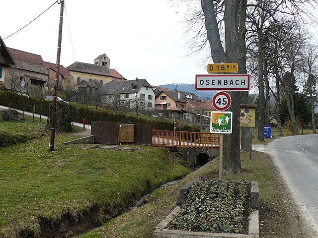

Osenbach
- commune in Haut-Rhin, France
- Country:
- Postal Code: 68570
- Coordinates: 47° 59' 10" N, 7° 13' 5" E
- GPS tracks (wikiloc): [Link]
- Area: 5.6 sq km
- Population: 889

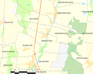
Oberentzen
- commune in Haut-Rhin, France
- Country:
- Postal Code: 68127
- Coordinates: 47° 56' 37" N, 7° 22' 40" E
- GPS tracks (wikiloc): [Link]
- Area: 8.81 sq km
- Population: 614

Munwiller
- commune in Haut-Rhin, France
- Country:
- Postal Code: 68250
- Coordinates: 47° 55' 50" N, 7° 20' 42" E
- GPS tracks (wikiloc): [Link]
- Area: 6.74 sq km
- Population: 485

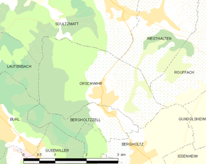
Orschwihr
- commune in Haut-Rhin, France
- Country:
- Postal Code: 68500
- Coordinates: 47° 56' 5" N, 7° 13' 56" E
- GPS tracks (wikiloc): [Link]
- AboveSeaLevel: 259 м m
- Area: 7.09 sq km
- Population: 1061
- Web site: [Link]


Soultzmatt
- commune in Haut-Rhin, France
- Country:
- Postal Code: 68570
- Coordinates: 47° 57' 42" N, 7° 14' 17" E
- GPS tracks (wikiloc): [Link]
- Area: 19.57 sq km
- Population: 2377
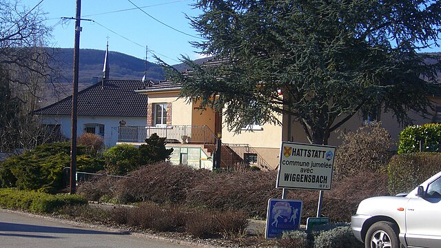

Hattstatt
- commune in Haut-Rhin, France
- Country:
- Postal Code: 68420
- Coordinates: 48° 0' 40" N, 7° 18' 0" E
- GPS tracks (wikiloc): [Link]
- Area: 5.98 sq km
- Population: 797


Bergholtz
- commune in Haut-Rhin, France
- Country:
- Postal Code: 68500
- Coordinates: 47° 55' 0" N, 7° 14' 46" E
- GPS tracks (wikiloc): [Link]
- Area: 4.24 sq km
- Population: 1049


Biltzheim
- commune in Haut-Rhin, France
- Country:
- Postal Code: 68127
- Coordinates: 47° 57' 28" N, 7° 23' 17" E
- GPS tracks (wikiloc): [Link]
- AboveSeaLevel: 202 м m
- Area: 7.15 sq km
- Population: 409
- Web site: [Link]

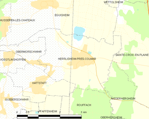
Herrlisheim-près-Colmar
- commune in Haut-Rhin, France
- Country:
- Postal Code: 68420
- Coordinates: 48° 1' 8" N, 7° 19' 34" E
- GPS tracks (wikiloc): [Link]
- Area: 7.68 sq km
- Population: 1794
- Web site: [Link]


Gundolsheim
- commune in Haut-Rhin, France
- Country:
- Postal Code: 68250
- Coordinates: 47° 55' 47" N, 7° 17' 37" E
- GPS tracks (wikiloc): [Link]
- Area: 8.22 sq km
- Population: 708


Westhalten
- commune in Haut-Rhin, France
- Country:
- Postal Code: 68250
- Coordinates: 47° 57' 26" N, 7° 15' 31" E
- GPS tracks (wikiloc): [Link]
- AboveSeaLevel: 396 м m
- Area: 10.98 sq km
- Population: 978


Wasserbourg
- commune in Haut-Rhin, France
- Country:
- Postal Code: 68230
- Coordinates: 48° 0' 10" N, 7° 9' 30" E
- GPS tracks (wikiloc): [Link]
- Area: 9.47 sq km
- Population: 463