Oberentzen (Oberentzen)

- commune in Haut-Rhin, France
- Country:

- Postal Code: 68127
- Coordinates: 47° 56' 37" N, 7° 22' 40" E


- GPS tracks (wikiloc): [Link]
- Area: 8.81 sq km
- Population: 614
- Wikipedia en: wiki(en)
- Wikipedia: wiki(fr)
- Wikidata storage: Wikidata: Q149339
- Wikipedia Commons Category: [Link]
- Freebase ID: [/m/03nstgc]
- Freebase ID: [/m/03nstgc]
- GeoNames ID: Alt: [6441553]
- GeoNames ID: Alt: [6441553]
- SIREN number: [216802413]
- SIREN number: [216802413]
- BnF ID: [15271943n]
- BnF ID: [15271943n]
- INSEE municipality code: 68241
- INSEE municipality code: 68241
Shares border with regions:

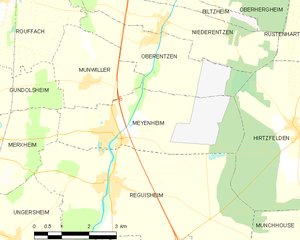
Meyenheim
- commune in Haut-Rhin, France
- Country:
- Postal Code: 68890
- Coordinates: 47° 54' 48" N, 7° 21' 21" E
- GPS tracks (wikiloc): [Link]
- Area: 12.78 sq km
- Population: 1455


Niederentzen
- commune in Haut-Rhin, France
- Country:
- Postal Code: 68127
- Coordinates: 47° 56' 52" N, 7° 22' 52" E
- GPS tracks (wikiloc): [Link]
- Area: 8.81 sq km
- Population: 709
- Web site: [Link]


Rouffach
- commune in Haut-Rhin, France
- Country:
- Postal Code: 68250
- Coordinates: 47° 57' 28" N, 7° 17' 52" E
- GPS tracks (wikiloc): [Link]
- Area: 40.05 sq km
- Population: 4505
- Web site: [Link]

Munwiller
- commune in Haut-Rhin, France
- Country:
- Postal Code: 68250
- Coordinates: 47° 55' 50" N, 7° 20' 42" E
- GPS tracks (wikiloc): [Link]
- Area: 6.74 sq km
- Population: 485


Biltzheim
- commune in Haut-Rhin, France
- Country:
- Postal Code: 68127
- Coordinates: 47° 57' 28" N, 7° 23' 17" E
- GPS tracks (wikiloc): [Link]
- AboveSeaLevel: 202 м m
- Area: 7.15 sq km
- Population: 409
- Web site: [Link]

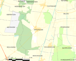
Hirtzfelden
- commune in Haut-Rhin, France
- Country:
- Postal Code: 68740
- Coordinates: 47° 54' 42" N, 7° 26' 43" E
- GPS tracks (wikiloc): [Link]
- Area: 22.1 sq km
- Population: 1217