Roulans (Roulans)
- commune in Doubs, France
Roulans is a small commune located in the Doubs department in the Bourgogne-Franche-Comté region of eastern France. While it may not be as widely known for hiking as some other areas in France, it offers natural beauty and a peaceful environment for outdoor activities.
Hiking Opportunities in and Around Roulans:
-
Local Trails: There are several trails in and around Roulans that feature picturesque landscapes, including forests, rolling hills, and views of the surrounding countryside. Many of the paths are suitable for both beginners and advanced hikers.
-
Nearby Natural Parks: The proximity to the Doubs Valley and other natural parks provides ample opportunity for hiking. Exploring these areas can lead you to stunning natural vistas and diverse ecosystems.
-
Vallon du Doubs: A short drive from Roulans, this area offers beautiful trails along the Doubs River, where you can enjoy river views and wildlife.
-
Regional Hiking Networks: Roulans is part of a broader network of hiking trails in the Bourgogne-Franche-Comté region. You can find maps and information about longer treks and multi-day hikes that connect different towns and points of interest.
Tips for Hiking in Roulans:
-
Check the Weather: The weather in the area can change quickly, so it's important to check conditions before heading out.
-
Trail Maps: Consider carrying a detailed map or using a hiking app to navigate the trails effectively.
-
Gear Up Appropriately: Wear comfortable hiking boots and gear suitable for the terrain and weather conditions.
-
Stay Hydrated: Always have enough water with you, especially if you plan on hiking for several hours.
-
Respect Nature: Follow Leave No Trace principles to help preserve the natural beauty of the area.
Conclusion:
While Roulans may not be a major hiking destination, it offers a quaint and serene environment for those looking to explore the outdoors. The surrounding region provides further trails and opportunities for hiking enthusiasts. Whether you are looking for a casual stroll or a more challenging hike, you can find suitable options in and around this charming locale.
- Country:

- Postal Code: 25640
- Coordinates: 47° 18' 59" N, 6° 14' 0" E


- GPS tracks (wikiloc): [Link]
- AboveSeaLevel: 350 м m
- Area: 8.31 sq km
- Population: 1125
- Web site: http://www.roulans.fr/
- Wikipedia en: wiki(en)
- Wikipedia: wiki(fr)
- Wikidata storage: Wikidata: Q837554
- Wikipedia Commons Category: [Link]
- Freebase ID: [/m/03mhchz]
- Freebase ID: [/m/03mhchz]
- GeoNames ID: Alt: [6453865]
- GeoNames ID: Alt: [6453865]
- SIREN number: [212505085]
- SIREN number: [212505085]
- BnF ID: [15252734z]
- BnF ID: [15252734z]
- VIAF ID: Alt: [243861002]
- VIAF ID: Alt: [243861002]
- PACTOLS thesaurus ID: [pcrt1HDcUXoMox]
- PACTOLS thesaurus ID: [pcrt1HDcUXoMox]
- INSEE municipality code: 25508
- INSEE municipality code: 25508
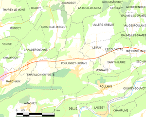
Shares border with regions:


Ougney-Douvot
- commune in Doubs, France
Ougney-Douvot is a small commune located in the Bourgogne-Franche-Comté region of France. While it may not be as widely recognized as larger hiking destinations, it offers some charming opportunities for outdoor enthusiasts looking to explore the natural beauty of rural France....
- Country:

- Postal Code: 25640
- Coordinates: 47° 18' 41" N, 6° 15' 29" E


- GPS tracks (wikiloc): [Link]
- Area: 6.56 sq km
- Population: 235


Breconchaux
- commune in Doubs, France
It seems you might be referring to the Brecon Beacons, a stunning National Park located in South Wales known for its beautiful landscapes, rolling hills, and diverse wildlife. Here are some details about hiking there:...
- Country:

- Postal Code: 25640
- Coordinates: 47° 20' 25" N, 6° 16' 0" E


- GPS tracks (wikiloc): [Link]
- Area: 3.26 sq km
- Population: 97


Deluz
- commune in Doubs, France
Deluz, located in the Doubs department of the Bourgogne-Franche-Comté region in France, offers a beautiful setting for hiking enthusiasts. The area is characterized by its picturesque landscapes, rolling hills, dense forests, and varied terrain, making it a great destination for outdoor activities....
- Country:

- Postal Code: 25960
- Coordinates: 47° 17' 40" N, 6° 12' 3" E


- GPS tracks (wikiloc): [Link]
- Area: 8.03 sq km
- Population: 625


Laissey
- commune in Doubs, France
Laissey is a charming village located in the Jura Mountains in France, which offers scenic hiking opportunities for outdoor enthusiasts. When planning a hike in this region, here are some key points to consider:...
- Country:

- Postal Code: 25820
- Coordinates: 47° 17' 52" N, 6° 13' 51" E


- GPS tracks (wikiloc): [Link]
- Area: 2.86 sq km
- Population: 443
- Web site: [Link]


Saint-Hilaire
- commune in Doubs, France
Saint-Hilaire in the Doubs department of France is known for its beautiful landscapes and outdoor recreational opportunities, including hiking. The region is characterized by its rolling hills, lush forests, and picturesque countryside, making it a great destination for both casual walkers and experienced hikers....
- Country:

- Postal Code: 25640
- Coordinates: 47° 20' 6" N, 6° 14' 30" E


- GPS tracks (wikiloc): [Link]
- Area: 2.64 sq km
- Population: 160


Pouligney-Lusans
- commune in Doubs, France
Pouligney-Lusans is a small commune located in the Doubs department of the Bourgogne-Franche-Comté region in eastern France. While it may not be a widely recognized hiking destination, the surrounding area does offer opportunities for nature walks and hiking experiences....
- Country:

- Postal Code: 25640
- Coordinates: 47° 19' 43" N, 6° 12' 14" E


- GPS tracks (wikiloc): [Link]
- Area: 11.6 sq km
- Population: 835


Vennans
- commune in Doubs, France
It seems like there may be a typo in your question, as "Vennans" doesn't correspond to a well-known hiking destination. However, if you meant a specific area or region, such as Vennans in a certain country or context (like perhaps a mountain range, national park, or hiking trail), please clarify so I can provide you with the best information. Alternatively, if you were referring to a popular hiking destination nearby or a different name, just let me know, and I can give you detailed insights about hiking in that location!...
- Country:

- Postal Code: 25640
- Coordinates: 47° 19' 45" N, 6° 14' 12" E


- GPS tracks (wikiloc): [Link]
- Area: 1.36 sq km
- Population: 258

