
Roussillon (Roussillon)

- commune in Vaucluse, France
 Hiking in Roussillon
Roussillon, located in the Vaucluse department of the Provence-Alpes-Côte d'Azur region in southeastern France, is renowned for its stunning landscapes, rich ochre deposits, and charming village atmosphere. Hiking in this area offers a unique blend of natural beauty and cultural heritage. Here are some key aspects to consider:
Highlights of Hiking in Roussillon:
-
Ochre Trails: One of the most famous hiking routes in the area is the Sentier des Ocres, which winds through the colorful ochre cliffs and quarry. This trail showcases stunning hues of red, orange, and yellow, making it a photographer's dream. The route offers several loops, with varying lengths and difficulty levels, so you can choose one that suits your preferences.
-
Panoramic Views: The trails around Roussillon provide spectacular views of the surrounding Luberon region, vineyards, and the Mont Ventoux in the distance. Many vantage points along the trails allow you to pause and appreciate the idyllic landscapes.
-
Marche des Sens: This is a relatively easy hike that encourages you to engage your senses. It focuses on the sights, sounds, and smells of nature, enhancing your experience in the beautiful environment.
-
Cultural Aspects: Roussillon itself is charming to explore, with its ochre-colored buildings and art galleries. Make sure to take some time after your hike to stroll through the village and perhaps visit local shops and cafes.
-
Flora and Fauna: The region is rich in biodiversity, making the hiking experience even more enjoyable. As you hike, you may spot various plants and wildlife native to Provence, including lavender fields in the warmer months.
Practical Tips:
-
Best Time to Hike: The ideal seasons for hiking in Roussillon are spring (April to June) and fall (September to October), when temperatures are pleasant, and the scenery is at its most vibrant.
-
Trail Difficulty: Most trails around Roussillon are well-marked and vary from easy to moderate in difficulty. However, be sure to check trail conditions and difficulty levels before embarking on your hike.
-
What to Bring: Always carry plenty of water, snacks, a map or GPS device, sun protection, and suitable hiking footwear. If you plan to hike in the warmer months, pack a hat and wear appropriate clothing for the weather.
-
Guided Tours: If you prefer a structured experience, consider joining a guided hiking tour, which can provide insights into the local geology, flora, and history of the area.
Hiking in Roussillon is a remarkable experience, combining stunning natural beauty with cultural exploration. Whether you are a seasoned hiker or a casual walker, the trails around this enchanting village will surely provide unforgettable memories.
- Country:

- Postal Code: 84220
- Coordinates: 43° 54' 8" N, 5° 17' 34" E


- GPS tracks (wikiloc): [Link]
- Area: 29.77 sq km
- Population: 1328
- Web site: http://roussillon-en-provence.fr
- Wikipedia en: wiki(en)
- Wikipedia: wiki(fr)
- Wikidata storage: Wikidata: Q321139
- Wikipedia Commons Gallery: [Link]
- Wikipedia Commons Category: [Link]
- Freebase ID: [/m/05bcgw]
- GeoNames ID: Alt: [2982456]
- SIREN number: [218401024]
- BnF ID: [15278082r]
- PACTOLS thesaurus ID: [pcrtPPzcKAiSSQ]
- INSEE municipality code: 84102
Shares border with regions:


Goult
- commune in Vaucluse, France
Hiking in Goult
Goult, located in the Luberon region of Provence, France, is a charming and picturesque village surrounded by stunning landscapes, making it a great destination for hiking enthusiasts. Here are some key points about hiking in and around Goult:...
- Country:
- Postal Code: 84220
- Coordinates: 43° 51' 48" N, 5° 14' 37" E
- GPS tracks (wikiloc): [Link]
- Area: 23.77 sq km
- Population: 1126
- Web site: [Link]


Saint-Saturnin-lès-Apt
- commune in Vaucluse, France
Hiking in Saint-Saturnin-lès-Apt
Saint-Saturnin-lès-Apt, located in the Vaucluse department of the Provence region in France, is surrounded by stunning natural landscapes, making it a fantastic location for hiking enthusiasts. The area features picturesque trails that showcase the beautiful scenery of the Luberon Regional Nature Park, including rocky outcrops, vineyards, and charming villages....
- Country:
- Postal Code: 84490
- Coordinates: 43° 56' 39" N, 5° 23' 2" E
- GPS tracks (wikiloc): [Link]
- AboveSeaLevel: 411 м m
- Area: 75.79 sq km
- Population: 2732
- Web site: [Link]

Gargas
- commune in Vaucluse, France
Hiking in Gargas
Gargas, located in the Vaucluse department of the Provence-Alpes-Côte d'Azur region in southeastern France, is a charming area known for its picturesque landscapes, historical sites, and unique geological features. Hiking in and around Gargas offers a wonderful opportunity to explore the natural beauty of the region, including the iconic ochre cliffs that the area is famous for....
- Country:
- Postal Code: 84400
- Coordinates: 43° 54' 7" N, 5° 21' 31" E
- GPS tracks (wikiloc): [Link]
- Area: 14.9 sq km
- Population: 2976
- Web site: [Link]


Bonnieux
- commune in Vaucluse, France
Hiking in Bonnieux
Bonnieux, a charming village located in the Vaucluse region of the Provence-Alpes-Côte d'Azur, offers beautiful hiking opportunities amid stunning landscapes, vineyards, and ancient ruins. The surrounding Luberon National Park is particularly rich in trails that cater to various skill levels, from easy walks to more challenging hikes....
- Country:
- Postal Code: 84480
- Coordinates: 43° 49' 23" N, 5° 18' 25" E
- GPS tracks (wikiloc): [Link]
- Area: 51.12 sq km
- Population: 1362
- Web site: [Link]
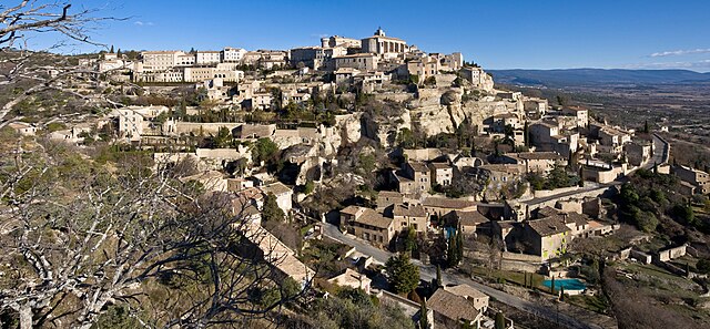

Gordes
- commune in Vaucluse, France
Hiking in Gordes
Gordes, a picturesque village in the Luberon region of Provence, France, is surrounded by stunning landscapes that are perfect for hiking enthusiasts. The area is characterized by its rolling hills, vineyards, olive groves, and rocky outcrops, providing a diverse range of trails suitable for different skill levels....
- Country:
- Postal Code: 84220
- Coordinates: 43° 54' 40" N, 5° 12' 1" E
- GPS tracks (wikiloc): [Link]
- Area: 48.04 sq km
- Population: 1974
- Web site: [Link]

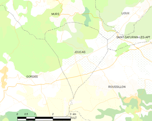
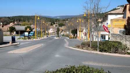
Joucas
- commune in Vaucluse, France
Hiking in Joucas
Joucas is a charming village located in the Provence region of France, known for its picturesque landscapes and scenic views of the Luberon Valley. Hiking in and around Joucas offers a blend of beautiful natural scenery, stunning vistas, and an opportunity to explore local flora and fauna....
- Country:
- Postal Code: 84220
- Coordinates: 43° 55' 33" N, 5° 15' 8" E
- GPS tracks (wikiloc): [Link]
- Area: 8.29 sq km
- Population: 329