Ruden (Ruden)
- municipality in Austria
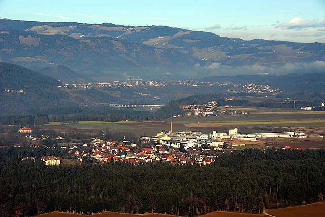
 Hiking in Ruden
Ruden, a small town located in the Carinthia region of Austria, is surrounded by stunning natural landscapes that offer excellent hiking opportunities. Here are some highlights and tips for hiking in and around Ruden:
Trails and Terrain
-
Scenic Routes: Ruden is close to the foothills of the Julian Alps and offers a variety of trails ranging from easy walks to more challenging hikes. The terrain varies from rolling hills to rugged mountain paths.
-
Local Trails: Look for local hiking maps that highlight specific trails around Ruden, such as those leading to nearby forests, meadows, and viewpoints. Many trails are well-marked and cater to different skill levels.
-
Nature Reserves: The surrounding area is rich in flora and fauna, making it ideal for nature enthusiasts. Be on the lookout for local wildlife and enjoy the diverse plant life along the trails.
Recommended Hikes
- Local Hills: Shorter hikes in the vicinity of Ruden can lead you to beautiful vantage points with panoramic views of the Carinthian landscape.
- Tour of the Lakes: Consider trails that take you around the nearby lakes such as Lake Klopein, known for its clear waters and recreational activities.
Tips for Hiking
- Weather Check: Always check the weather before heading out, as conditions can change rapidly in mountainous regions.
- Appropriate Gear: Wear good quality hiking boots and bring layers of clothing, a rain jacket, and enough water and snacks for your hike.
- Safety: Inform someone about your hiking plan and expected return time, especially if hiking in less-trafficked areas.
Local Resources
- Tourist Information: Visit the local tourist office for maps, recommended trails, and any guided hikes that may be available.
- Community Events: Check for local events or guided hikes, especially during the summer months, which can enhance your experience and provide knowledge of the area.
Conclusion
Hiking in Ruden, Austria, offers a fantastic way to explore the natural beauty of the region. Whether you're looking for a leisurely stroll or a more challenging hike, the area is sure to provide a memorable outdoor experience. Always prioritize safety and enjoy the breathtaking landscapes that this charming part of Austria has to offer!
- Country:

- Postal Code: 9113
- Local Dialing Code: 0 42 34
- Licence Plate Code: VK
- Coordinates: 46° 39' 23" N, 14° 46' 11" E


- GPS tracks (wikiloc): [Link]
- AboveSeaLevel: 465 м m
- Area: 42.44 sq km
- Population: 1530
- Web site: http://www.ruden.at/
- Wikipedia en: wiki(en)
- Wikipedia: wiki(de)
- Wikidata storage: Wikidata: Q126811
- Wikipedia Commons Gallery: [Link]
- Wikipedia Commons Category: [Link]
- Freebase ID: [/m/02qsm5c]
- GeoNames ID: Alt: [7871677]
- VIAF ID: Alt: [236846257]
- Austrian municipality key: [20812]
Shares border with regions:

Völkermarkt
- municipality in Austria
Hiking in Völkermarkt
Völkermarkt, located in the southern part of Austria in Carinthia, provides some beautiful hiking opportunities amidst stunning natural landscapes. The region is characterized by its picturesque countryside, lakes, and the nearby Karawanken mountain range. Here are some key points to consider when hiking in Völkermarkt:...
- Country:
- Postal Code: 9100
- Licence Plate Code: VK
- Coordinates: 46° 39' 44" N, 14° 38' 4" E
- GPS tracks (wikiloc): [Link]
- AboveSeaLevel: 462 м m
- Area: 137.44 sq km
- Population: 10948
- Web site: [Link]

Eberndorf
- municipality in Austria
Hiking in Eberndorf
Eberndorf, located in Austria's Carinthia region, offers a range of hiking opportunities set against a stunning alpine backdrop. This picturesque area is characterized by beautiful landscapes, including rolling hills, tranquil lakes, and dense forests....
- Country:
- Postal Code: 9141
- Local Dialing Code: 04236
- Licence Plate Code: VK
- Coordinates: 46° 35' 29" N, 14° 38' 37" E
- GPS tracks (wikiloc): [Link]
- AboveSeaLevel: 476 м m
- Area: 68 sq km
- Population: 5862
- Web site: [Link]

Sankt Paul im Lavanttal
- municipality in Austria
Hiking in Sankt Paul im Lavanttal
Sankt Paul im Lavanttal is a picturesque area in Austria, located in Carinthia. It offers a variety of hiking opportunities suitable for all skill levels, making it a great destination for outdoor enthusiasts. Here are some highlights of hiking in Sankt Paul im Lavanttal:...
- Country:
- Postal Code: 9470
- Local Dialing Code: 04357
- Licence Plate Code: WO
- Coordinates: 46° 42' 8" N, 14° 52' 7" E
- GPS tracks (wikiloc): [Link]
- AboveSeaLevel: 412 м m
- Area: 47.32 sq km
- Population: 3303
- Web site: [Link]

Griffen
- municipality in Austria
Hiking in Griffen
Griffen, Austria, is a charming town situated in the Carinthia region, known for its stunning landscapes and proximity to the foothills of the Alps. Hiking in this area can be a rewarding experience, offering a mix of scenic routes, historical sites, and natural beauty....
- Country:
- Postal Code: 9112
- Local Dialing Code: 04233
- Licence Plate Code: VK
- Coordinates: 46° 42' 16" N, 14° 43' 58" E
- GPS tracks (wikiloc): [Link]
- AboveSeaLevel: 484 м m
- Area: 74.74 sq km
- Population: 3466
- Web site: [Link]


Neuhaus
- municipality in Austria
Hiking in Neuhaus
Neuhaus, in Carinthia, Austria, is a charming location for hiking enthusiasts. Nestled in the breathtaking landscapes of the Alps, it offers a variety of trails suitable for different skill levels, ranging from leisurely walks to more challenging hikes. Here are some highlights of hiking in this region:...
- Country:
- Postal Code: 9155
- Local Dialing Code: 0 43 56
- Licence Plate Code: VK
- Coordinates: 46° 38' 36" N, 14° 53' 16" E
- GPS tracks (wikiloc): [Link]
- AboveSeaLevel: 442 м m
- Area: 36.33 sq km
- Population: 1040
- Web site: [Link]

Bleiburg
- municipality in Austria
Hiking in Bleiburg
Bleiburg, located in Austria, is a picturesque town set against the backdrop of the Karawanken mountain range. This region offers various hiking opportunities for all levels, making it an attractive destination for outdoor enthusiasts....
- Country:
- Postal Code: 9150
- Local Dialing Code: 04235
- Licence Plate Code: VK
- Coordinates: 46° 35' 24" N, 14° 47' 56" E
- GPS tracks (wikiloc): [Link]
- AboveSeaLevel: 479 м m
- Area: 69.72 sq km
- Population: 4072
- Web site: [Link]

Lavamünd
- municipality in Austria
Hiking in Lavamünd
Lavamünd is a picturesque town located in Austria, near the border with Slovenia, and is surrounded by beautiful natural landscapes, making it an excellent destination for hiking enthusiasts. Here are some highlights and tips for hiking in the Lavamünd area:...
- Country:
- Postal Code: 9473
- Local Dialing Code: 04356
- Licence Plate Code: WO
- Coordinates: 46° 38' 30" N, 14° 56' 30" E
- GPS tracks (wikiloc): [Link]
- AboveSeaLevel: 348 м m
- Area: 93.78 sq km
- Population: 2941
- Web site: [Link]