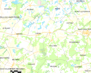
Ruffec (Ruffec)
- commune in Indre, France
- Country:

- Postal Code: 36300
- Coordinates: 46° 37' 45" N, 1° 10' 17" E


- GPS tracks (wikiloc): [Link]
- Area: 40.93 sq km
- Population: 599
- Wikipedia en: wiki(en)
- Wikipedia: wiki(fr)
- Wikidata storage: Wikidata: Q669828
- Wikipedia Commons Category: [Link]
- Freebase ID: [/m/03nw5nm]
- GeoNames ID: Alt: [6432960]
- SIREN number: [213601768]
- BnF ID: [15257480h]
- VIAF ID: Alt: [146495810]
- Library of Congress authority ID: Alt: [n81060405]
- PACTOLS thesaurus ID: [pcrtBErSgJaPdm]
- INSEE municipality code: 36176
Shares border with regions:


Bélâbre
- commune in Indre, France
- Country:

- Postal Code: 36370
- Coordinates: 46° 33' 5" N, 1° 9' 29" E


- GPS tracks (wikiloc): [Link]
- Area: 40.14 sq km
- Population: 980
- Web site: [Link]


Le Blanc
- commune in Indre, France
- Country:

- Postal Code: 36300
- Coordinates: 46° 38' 1" N, 1° 3' 46" E


- GPS tracks (wikiloc): [Link]
- Area: 57.61 sq km
- Population: 6572
- Web site: [Link]


Ciron
- commune in Indre, France
- Country:

- Postal Code: 36300
- Coordinates: 46° 37' 38" N, 1° 14' 42" E


- GPS tracks (wikiloc): [Link]
- Area: 57.94 sq km
- Population: 562


Rosnay
- commune in Indre, France
- Country:

- Postal Code: 36300
- Coordinates: 46° 42' 4" N, 1° 12' 52" E


- GPS tracks (wikiloc): [Link]
- Area: 59.03 sq km
- Population: 506


Chalais
- commune in Indre, France
- Country:

- Postal Code: 36370
- Coordinates: 46° 32' 11" N, 1° 11' 49" E


- GPS tracks (wikiloc): [Link]
- Area: 39.65 sq km
- Population: 145
