Saint-André-de-Bohon (Saint-André-de-Bohon)

- commune in Manche, France
- Country:

- Postal Code: 50500
- Coordinates: 49° 14' 4" N, 1° 15' 8" E


- GPS tracks (wikiloc): [Link]
- Area: 10.43 sq km
- Population: 334
- Wikipedia en: wiki(en)
- Wikipedia: wiki(fr)
- Wikidata storage: Wikidata: Q1062349
- Wikipedia Commons Category: [Link]
- Freebase ID: [/m/03x_z2q]
- Freebase ID: [/m/03x_z2q]
- GeoNames ID: Alt: [6435563]
- GeoNames ID: Alt: [6435563]
- SIREN number: [215004458]
- SIREN number: [215004458]
- BnF ID: [15262419f]
- BnF ID: [15262419f]
- INSEE municipality code: 50445
- INSEE municipality code: 50445
Shares border with regions:

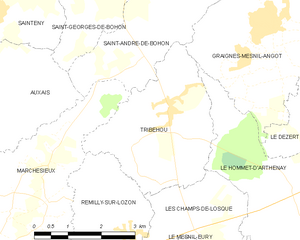
Tribehou
- commune in Manche, France
- Country:
- Postal Code: 50620
- Coordinates: 49° 12' 50" N, 1° 14' 38" E
- GPS tracks (wikiloc): [Link]
- Area: 9.97 sq km
- Population: 533
- Web site: [Link]


Saint-Georges-de-Bohon
- former commune in Manche, France
- Country:
- Postal Code: 50500
- Coordinates: 49° 15' 2" N, 1° 16' 10" E
- GPS tracks (wikiloc): [Link]
- Area: 13.96 sq km
- Population: 403


Marchésieux
- commune in Manche, France
- Country:
- Postal Code: 50190
- Coordinates: 49° 11' 15" N, 1° 17' 28" E
- GPS tracks (wikiloc): [Link]
- Area: 19.89 sq km
- Population: 724


Graignes-Mesnil-Angot
- commune in Manche, France
- Country:
- Postal Code: 50620
- Coordinates: 49° 14' 17" N, 1° 12' 5" E
- GPS tracks (wikiloc): [Link]
- Area: 18.35 sq km
- Population: 784


Montmartin-en-Graignes
- commune in Manche, France
- Country:
- Postal Code: 50620
- Coordinates: 49° 16' 31" N, 1° 8' 48" E
- GPS tracks (wikiloc): [Link]
- Area: 30.34 sq km
- Population: 588

Auxais
- commune in Manche, France
- Country:
- Postal Code: 50500
- Coordinates: 49° 12' 47" N, 1° 17' 55" E
- GPS tracks (wikiloc): [Link]
- Area: 7.76 sq km
- Population: 173