Saint-André-et-Appelles (Saint-André-et-Appelles)

- commune in Gironde, France
- Country:

- Postal Code: 33220
- Coordinates: 44° 49' 8" N, 0° 11' 39" E


- GPS tracks (wikiloc): [Link]
- Area: 10.25 sq km
- Population: 710
- Wikipedia en: wiki(en)
- Wikipedia: wiki(fr)
- Wikidata storage: Wikidata: Q192563
- Wikipedia Commons Category: [Link]
- Freebase ID: [/m/03ns0qz]
- SIREN number: [213303696]
- BnF ID: [15256418v]
- PACTOLS thesaurus ID: [pcrt9l0tSnFtZ4]
- INSEE municipality code: 33369
Shares border with regions:


Les Lèves-et-Thoumeyragues
- commune in Gironde, France
- Country:
- Postal Code: 33220
- Coordinates: 44° 47' 35" N, 0° 10' 29" E
- GPS tracks (wikiloc): [Link]
- AboveSeaLevel: 80 м m
- Area: 15.58 sq km
- Population: 566

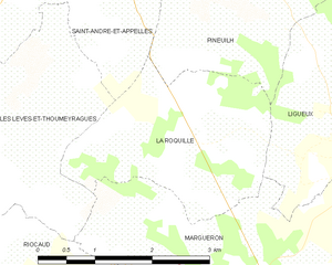
La Roquille
- commune in Gironde, France
- Country:
- Postal Code: 33220
- Coordinates: 44° 47' 28" N, 0° 13' 54" E
- GPS tracks (wikiloc): [Link]
- Area: 6.51 sq km
- Population: 337


Saint-Quentin-de-Caplong
- commune in Gironde, France
- Country:
- Postal Code: 33220
- Coordinates: 44° 47' 1" N, 0° 7' 53" E
- GPS tracks (wikiloc): [Link]
- Area: 11.27 sq km
- Population: 247

Port-Sainte-Foy-et-Ponchapt
- commune in Dordogne, France
- Country:
- Postal Code: 33220
- Coordinates: 44° 50' 0" N, 0° 12' 0" E
- GPS tracks (wikiloc): [Link]
- AboveSeaLevel: 18 м m
- Area: 18.32 sq km
- Population: 2503
- Web site: [Link]


Eynesse
- commune in Gironde, France
- Country:
- Postal Code: 33220
- Coordinates: 44° 49' 30" N, 0° 9' 16" E
- GPS tracks (wikiloc): [Link]
- Area: 7.59 sq km
- Population: 586


Pineuilh
- commune in Gironde, France
- Country:
- Postal Code: 33220
- Coordinates: 44° 49' 52" N, 0° 13' 39" E
- GPS tracks (wikiloc): [Link]
- Area: 17.36 sq km
- Population: 4323
- Web site: [Link]