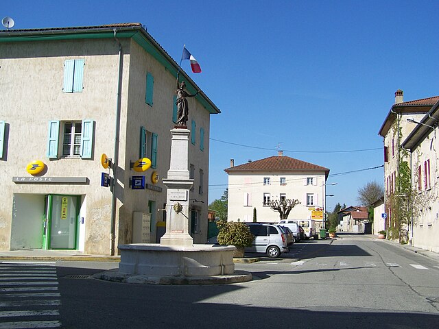
Saint-Antoine-l'Abbaye (Saint-Antoine-l'Abbaye)

- former commune in Isère, France
 Hiking in Saint-Antoine-l'Abbaye
Saint-Antoine-l'Abbaye, located in the Isère department of France, offers some wonderful hiking opportunities set against a backdrop of historical architecture and picturesque landscapes. The region is known for its medieval abbey, which adds cultural significance to your outdoor adventures.
Hiking Trails
-
Cultural and Historical Trails: There are several trails that incorporate local history, leading hikers through the village and to the abbey itself. You can discover charming streets and ancient structures while enjoying the surrounding natural beauty.
-
Nature Walks: The area surrounding Saint-Antoine-l'Abbaye includes lush countryside, forests, and gentle hills, ideal for nature walks. Look for trails that may wind through the nearby Vercors Regional Natural Park, which is not too far away and offers stunning views and diverse flora and fauna.
-
Circuit des Gorges de la Bourne: A bit farther from the village, this circuit offers dramatic views of the Bourne River and its gorges. It's suitable for those looking to explore more rugged terrain.
-
Family-Friendly Options: There are also easy, family-friendly trails available for those with children, allowing everyone to enjoy the outdoors without the stress of difficult terrain.
Preparing for Your Hike
- Best Time to Visit: Spring and early autumn are ideal for hiking in this region, as the weather is generally pleasant and the landscapes are particularly beautiful.
- What to Bring: Always ensure you have proper hiking boots, plenty of water, snacks, a map or GPS device, and appropriate clothing for the weather. Don't forget a camera to capture the stunning views and historical sites!
Tips
- Local Guides: Consider hiring a local guide for a more in-depth experience, especially if you're interested in the history and ecology of the area.
- Respect Nature: As in all hiking areas, be sure to follow Leave No Trace principles to preserve the natural beauty of the region for future generations.
Hiking in Saint-Antoine-l'Abbaye can be a rewarding experience combining physical activity with the exploration of culture and history. Enjoy your adventure!
- Country:

- Postal Code: 38160
- Coordinates: 45° 10' 30" N, 5° 13' 0" E


- GPS tracks (wikiloc): [Link]
- Area: 22.21 sq km
- Population: 1053
- Web site: http://www.saint-antoine-labbaye.fr
- Wikipedia en: wiki(en)
- Wikipedia: wiki(fr)
- Wikidata storage: Wikidata: Q636272
- Wikipedia Commons Gallery: [Link]
- Wikipedia Commons Category: [Link]
- Freebase ID: [/m/03g_5yt]
- BnF ID: [122443352]
- VIAF ID: Alt: [242198196]
- GND ID: Alt: [4258593-4]
- INSEE municipality code: 38359
Shares border with regions:


Dionay
- former commune in Isère, France
Hiking in Dionay
Dionay, located in the Auvergne-Rhône-Alpes region of France, is a picturesque area that offers beautiful hiking opportunities, particularly for those who enjoy nature, mountainous landscapes, and the tranquility of the countryside....
- Country:
- Postal Code: 38160
- Coordinates: 45° 12' 11" N, 5° 13' 11" E
- GPS tracks (wikiloc): [Link]
- Area: 14.01 sq km
- Population: 117
- Web site: [Link]


Montmiral
- commune in Drôme, France
Hiking in Montmiral
Montmiral, located in the picturesque region of the Occitanie near the Tarn department in France, offers a charming hiking experience surrounded by stunning landscapes and historical architecture. The area is known for its rolling hills, vineyards, and medieval villages, making it an excellent destination for outdoor enthusiasts and history buffs alike....
- Country:
- Postal Code: 26750
- Coordinates: 45° 9' 19" N, 5° 8' 59" E
- GPS tracks (wikiloc): [Link]
- Area: 26.69 sq km
- Population: 652
- Web site: [Link]


Saint-Bonnet-de-Chavagne
- commune in Isère, France
Hiking in Saint-Bonnet-de-Chavagne
Saint-Bonnet-de-Chavagne is a charming village located in the Isère department of the Auvergne-Rhône-Alpes region in France. It is surrounded by the natural beauty of the Vercors and Chartreuse mountain ranges, making it a great destination for hiking enthusiasts....
- Country:
- Postal Code: 38840
- Coordinates: 45° 7' 33" N, 5° 13' 55" E
- GPS tracks (wikiloc): [Link]
- Area: 15.18 sq km
- Population: 631
- Web site: [Link]

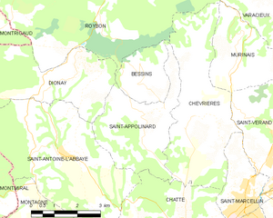
Saint-Appolinard
- commune in Isère, France
Hiking in Saint-Appolinard
Saint-Appolinard is a charming commune located in the Isère department in the Auvergne-Rhône-Alpes region of southeastern France. Known for its picturesque landscapes, it offers a variety of hiking opportunities suitable for different skill levels. Here are some highlights and tips for hiking in the area:...
- Country:
- Postal Code: 38160
- Coordinates: 45° 11' 20" N, 5° 15' 45" E
- GPS tracks (wikiloc): [Link]
- AboveSeaLevel: 380 м m
- Area: 10.76 sq km
- Population: 400
- Web site: [Link]


Montagne
- commune in Isère, France
Hiking in Montagne
Montagne, located in the Isère department of the Auvergne-Rhône-Alpes region in France, offers a variety of beautiful hiking opportunities suitable for different skill levels. This area is characterized by its stunning mountain landscapes, lush valleys, and diverse flora and fauna....
- Country:
- Postal Code: 38160
- Coordinates: 45° 8' 28" N, 5° 11' 32" E
- GPS tracks (wikiloc): [Link]
- Area: 8.78 sq km
- Population: 265

Chatte
- commune in Isère, France
Hiking in Chatte
It seems like you might be referring to a location that could be spelled differently or may not be widely recognized as a hiking destination. If you meant "Chattahoochee" or other known areas, please clarify. However, if you are referring to a lesser-known area, here's a general guide on how to approach hiking in any location:...
- Country:
- Postal Code: 38160
- Coordinates: 45° 8' 37" N, 5° 16' 59" E
- GPS tracks (wikiloc): [Link]
- Area: 22.81 sq km
- Population: 2496
- Web site: [Link]