Saint-Aunès (Saint-Aunès)

- commune in Hérault, France
- Country:

- Postal Code: 34130
- Coordinates: 43° 38' 24" N, 3° 57' 55" E


- GPS tracks (wikiloc): [Link]
- Area: 12.32 sq km
- Population: 3212
- Web site: http://www.saint-aunes.fr
- Wikipedia en: wiki(en)
- Wikipedia: wiki(fr)
- Wikidata storage: Wikidata: Q187030
- Wikipedia Commons Category: [Link]
- Freebase ID: [/m/03nv8kz]
- Freebase ID: [/m/03nv8kz]
- SIREN number: [213402407]
- SIREN number: [213402407]
- BnF ID: [15256841g]
- BnF ID: [15256841g]
- PACTOLS thesaurus ID: [pcrtKWVoiBfAMw]
- PACTOLS thesaurus ID: [pcrtKWVoiBfAMw]
- INSEE municipality code: 34240
- INSEE municipality code: 34240
Shares border with regions:


Baillargues
- commune in Hérault, France
- Country:
- Postal Code: 34670
- Coordinates: 43° 39' 40" N, 4° 0' 46" E
- GPS tracks (wikiloc): [Link]
- Area: 7.68 sq km
- Population: 7105
- Web site: [Link]


Le Crès
- commune in Hérault, France
- Country:
- Postal Code: 34920
- Coordinates: 43° 38' 50" N, 3° 56' 21" E
- GPS tracks (wikiloc): [Link]
- Area: 5.84 sq km
- Population: 9220
- Web site: [Link]

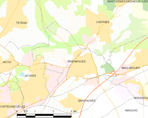
Vendargues
- commune in Hérault, France
- Country:
- Postal Code: 34740
- Coordinates: 43° 39' 28" N, 3° 58' 10" E
- GPS tracks (wikiloc): [Link]
- Area: 8.98 sq km
- Population: 6155


Castelnau-le-Lez
- commune in Hérault, France
- Country:
- Postal Code: 34170
- Coordinates: 43° 38' 10" N, 3° 54' 5" E
- GPS tracks (wikiloc): [Link]
- Area: 11.18 sq km
- Population: 19504
- Web site: [Link]

Montpellier
- city in Hérault, France
- Country:
- Postal Code: 34090; 34080; 34070; 34000
- Local Dialing Code: 467
- Coordinates: 43° 36' 39" N, 3° 52' 38" E
- GPS tracks (wikiloc): [Link]
- AboveSeaLevel: 121 м m
- Area: 56.88 sq km
- Population: 277639
- Web site: [Link]


Mauguio
- commune in Hérault, France
- Country:
- Postal Code: 34130
- Coordinates: 43° 36' 59" N, 4° 0' 27" E
- GPS tracks (wikiloc): [Link]
- Area: 49.56 sq km
- Population: 17219
- Web site: [Link]