
Saint-Benoît-du-Sault (Saint-Benoît-du-Sault)

- commune in Indre, France
- Country:

- Postal Code: 36170
- Coordinates: 46° 26' 26" N, 1° 23' 26" E


- GPS tracks (wikiloc): [Link]
- Area: 1.8 sq km
- Population: 612
- Web site: http://www.saint-benoit-du-sault.fr
- Wikipedia en: wiki(en)
- Wikipedia: wiki(fr)
- Wikidata storage: Wikidata: Q625293
- Wikipedia Commons Category: [Link]
- Freebase ID: [/m/0280j4n]
- SIREN number: [213601826]
- BnF ID: [15257486k]
- VIAF ID: Alt: [154351721]
- Library of Congress authority ID: Alt: [n91076879]
- PACTOLS thesaurus ID: [pcrtYri0jBgph6]
- SUDOC authorities ID: [026555603]
- INSEE municipality code: 36182
Shares border with regions:

La Châtre-Langlin
- commune in Indre, France
- Country:
- Postal Code: 36170
- Coordinates: 46° 24' 30" N, 1° 23' 21" E
- GPS tracks (wikiloc): [Link]
- Area: 27.4 sq km
- Population: 548


Parnac
- commune in Indre, France
- Country:
- Postal Code: 36170
- Coordinates: 46° 27' 12" N, 1° 26' 32" E
- GPS tracks (wikiloc): [Link]
- Area: 46.75 sq km
- Population: 508
- Web site: [Link]

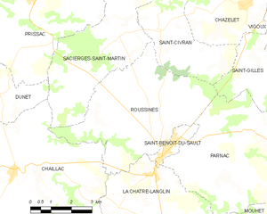
Roussines
- commune in Indre, France
- Country:
- Postal Code: 36170
- Coordinates: 46° 28' 7" N, 1° 23' 22" E
- GPS tracks (wikiloc): [Link]
- Area: 22.98 sq km
- Population: 354