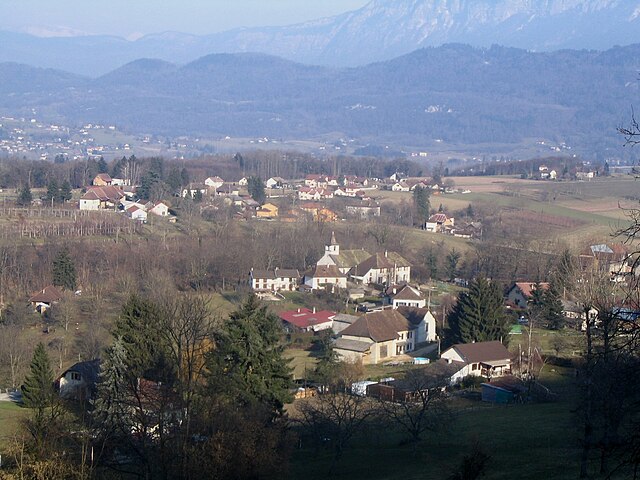
Saint-Bueil (Saint-Bueil)

- commune in Isère, France
 Hiking in Saint-Bueil
Saint-Bueil is a charming village located in the Isère department of the Auvergne-Rhône-Alpes region in southeastern France. While it may not be as widely recognized as some other hiking destinations in the area, it offers beautiful landscapes and opportunities for outdoor activities, including hiking.
Hiking in Saint-Bueil
-
Scenic Trails: The area around Saint-Bueil features a variety of trails that take you through picturesque countryside, forests, and open fields. You can enjoy the beauty of the local flora and fauna and the stunning views of the surrounding mountains.
-
Difficulty Levels: There are trails suitable for all levels of hikers, from easy walks suitable for families with children to more challenging routes for experienced hikers. It's advisable to check local maps or guides for detailed trail information.
-
Proximity to Natural Parks: Saint-Bueil is located near several natural parks. You can easily access the Chartreuse Regional Natural Park or Vercors Regional Natural Park, which offer more extensive hiking opportunities, with marked trails and stunning natural scenery.
-
Cultural Exploration: While hiking in the area, you can also explore the local culture and history. Look out for charming villages, historical landmarks, and local wildlife.
-
Best Seasons to Hike: The best times for hiking in the region are typically spring (April to June) and autumn (September to October) when the weather is mild, and the natural scenery is at its best.
-
Preparation: As always, when hiking, ensure you are well-prepared. Bring plenty of water, snacks, suitable clothing, and appropriate footwear. Always inform someone about your hiking plans and check the weather forecast.
-
Local Tourism Information: For the most current trail maps, guides, and specific recommendations, visit local tourist offices or websites that specialize in outdoor activities in the region.
Whether you're looking for a peaceful day hike or a more engaging outdoor adventure, Saint-Bueil and its surrounding areas can offer a delightful experience in nature!
- Country:

- Postal Code: 38620
- Coordinates: 45° 28' 38" N, 5° 41' 23" E


- GPS tracks (wikiloc): [Link]
- Area: 3.81 sq km
- Population: 702
- Wikipedia en: wiki(en)
- Wikipedia: wiki(fr)
- Wikidata storage: Wikidata: Q1151368
- Wikipedia Commons Gallery: [Link]
- Wikipedia Commons Category: [Link]
- Freebase ID: [/m/03nvj5v]
- GeoNames ID: Alt: [6433329]
- SIREN number: [213803729]
- BnF ID: [15258182m]
- INSEE municipality code: 38372
Shares border with regions:

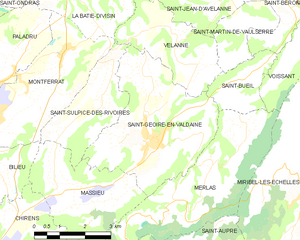
Saint-Geoire-en-Valdaine
- commune in Isère, France
Hiking in Saint-Geoire-en-Valdaine
Saint-Geoire-en-Valdaine is a picturesque commune located in the Isère department in the Auvergne-Rhône-Alpes region of southeastern France. The area is rich in natural beauty and offers various opportunities for hiking and outdoor activities....
- Country:
- Postal Code: 38620
- Coordinates: 45° 27' 25" N, 5° 38' 7" E
- GPS tracks (wikiloc): [Link]
- Area: 16.73 sq km
- Population: 2417
- Web site: [Link]
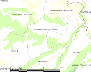
Saint-Martin-de-Vaulserre
- commune in Isère, France
Hiking in Saint-Martin-de-Vaulserre
Saint-Martin-de-Vaulserre is a charming commune located in the Isère department of the Auvergne-Rhône-Alpes region in southeastern France. The area offers various hiking opportunities that showcase the beautiful landscapes of the French Alps....
- Country:
- Postal Code: 38480
- Coordinates: 45° 29' 39" N, 5° 40' 58" E
- GPS tracks (wikiloc): [Link]
- Area: 3.92 sq km
- Population: 262
- Web site: [Link]


Merlas
- commune in Isère, France
Hiking in Merlas
Mereis, located in Portugal, is known for its beautiful natural landscapes and hiking opportunities. Here are some tips and information about hiking in the area:...
- Country:
- Postal Code: 38620
- Coordinates: 45° 26' 41" N, 5° 39' 46" E
- GPS tracks (wikiloc): [Link]
- Area: 15.64 sq km
- Population: 499


Saint-Albin-de-Vaulserre
- commune in Isère, France
Hiking in Saint-Albin-de-Vaulserre
Saint-Albin-de-Vaulserre is a charming commune located in the Isère department in the Auvergne-Rhône-Alpes region of southeastern France. While it is not as well-known as other hiking destinations, it offers beautiful rural landscapes and access to outdoor activities that can be enjoyed by hikers of all levels....
- Country:
- Postal Code: 38480
- Coordinates: 45° 30' 17" N, 5° 42' 9" E
- GPS tracks (wikiloc): [Link]
- Area: 4.99 sq km
- Population: 400


Velanne
- commune in Isère, France
Hiking in Velanne
Velanne is a charming village located in the French Alps, nestled within the picturesque Isère department. While not as widely known as some of its neighboring areas, it offers access to beautiful landscapes and hiking opportunities perfect for outdoor enthusiasts....
- Country:
- Postal Code: 38620
- Coordinates: 45° 29' 18" N, 5° 38' 54" E
- GPS tracks (wikiloc): [Link]
- Area: 8.04 sq km
- Population: 524


Voissant
- commune in Isère, France
Hiking in Voissant
Voissant is a charming village located in the Isère department of the Auvergne-Rhône-Alpes region in southeastern France. While it may not be as widely known as some of the larger hiking destinations, it offers a variety of outdoor activities and hiking opportunities amidst beautiful natural settings....
- Country:
- Postal Code: 38620
- Coordinates: 45° 29' 1" N, 5° 42' 36" E
- GPS tracks (wikiloc): [Link]
- Area: 3.88 sq km
- Population: 218