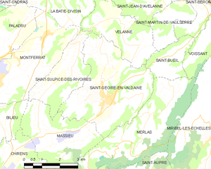
Velanne (Velanne)

- commune in Isère, France
 Hiking in Velanne
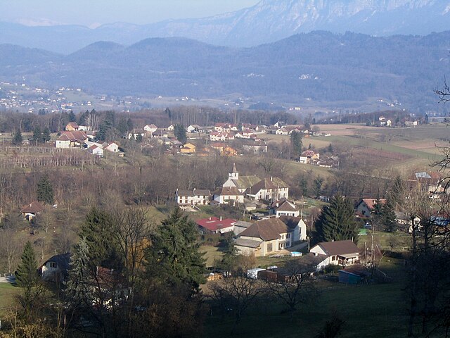
Velanne is a charming village located in the French Alps, nestled within the picturesque Isère department. While not as widely known as some of its neighboring areas, it offers access to beautiful landscapes and hiking opportunities perfect for outdoor enthusiasts.
Hiking in Velanne
-
Scenic Trails: The region features various trails that cater to different skill levels. Many paths wind through lush forests, meadows, and offer stunning views of the surrounding mountains.
-
Flora and Fauna: As you hike, keep an eye out for diverse plant species and wildlife native to the area. The mix of alpine and temperate ecosystems provides a rich variety of sights and sounds.
-
Nearby Attractions: Exploration of Velanne can be complemented by hikes to nearby natural attractions, such as lakes and higher mountain passes. The Chartreuse and Vercors ranges are also within reach, offering extensive trail networks for those looking for more challenging hikes.
-
Cultural Aspects: When hiking in Velanne, take time to appreciate the local culture and history. Some trails may lead you past historic landmarks, providing a glimpse into the region’s heritage.
-
Seasonal Considerations: Depending on the time of year you visit, the experience will vary greatly. Summer hikes offer vibrant green hills and blooming flowers, while late fall can provide breathtaking autumn colors. Winter hiking might also be available, though snow accumulation will necessitate appropriate gear and precautions.
-
Practical Tips: Always check local trail maps and guides for the latest information as conditions can change. It's advisable to go prepared with plenty of water, snacks, and a first aid kit. Additionally, wearing proper hiking boots and clothing suitable for changes in weather essentials for a safe and enjoyable trek.
Conclusion
Hiking in Velanne provides a unique opportunity to explore the serene beauty of the French Alps while enjoying a range of outdoor activities. Whether you're an experienced hiker or a casual walker, you'll find plenty to enjoy in this picturesque setting. Always plan ahead, respect nature, and take the time to immerse yourself in the breathtaking surroundings.
- Country:

- Postal Code: 38620
- Coordinates: 45° 29' 18" N, 5° 38' 54" E


- GPS tracks (wikiloc): [Link]
- Area: 8.04 sq km
- Population: 524
- Wikipedia en: wiki(en)
- Wikipedia: wiki(fr)
- Wikidata storage: Wikidata: Q605913
- Wikipedia Commons Category: [Link]
- Freebase ID: [/m/03nvk0_]
- GeoNames ID: Alt: [2970219]
- SIREN number: [213805310]
- BnF ID: [152583318]
- INSEE municipality code: 38531
Shares border with regions:

Saint-Geoire-en-Valdaine
- commune in Isère, France
Hiking in Saint-Geoire-en-Valdaine
Saint-Geoire-en-Valdaine is a picturesque commune located in the Isère department in the Auvergne-Rhône-Alpes region of southeastern France. The area is rich in natural beauty and offers various opportunities for hiking and outdoor activities....
- Country:
- Postal Code: 38620
- Coordinates: 45° 27' 25" N, 5° 38' 7" E
- GPS tracks (wikiloc): [Link]
- Area: 16.73 sq km
- Population: 2417
- Web site: [Link]


La Bâtie-Divisin
- former commune in Isère, France
Hiking in La Bâtie-Divisin
La Bâtie-Divisin is a charming commune in the Isère department of the Auvergne-Rhône-Alpes region in southeastern France. Nestled near the foothills of the Alps, it offers a picturesque setting for hiking enthusiasts. Here are some key points about hiking in and around La Bâtie-Divisin:...
- Country:
- Postal Code: 38490
- Coordinates: 45° 30' 36" N, 5° 35' 52" E
- GPS tracks (wikiloc): [Link]
- Area: 10.51 sq km
- Population: 917
- Web site: [Link]


Saint-Sulpice-des-Rivoires
- commune in Isère, France
Hiking in Saint-Sulpice-des-Rivoires
Saint-Sulpice-des-Rivoires is a charming commune located in the Isère department of the Auvergne-Rhône-Alpes region in southeastern France. The area is known for its beautiful landscapes and outdoor activities, including hiking. Here are some key points to consider if you're planning to hike in and around Saint-Sulpice-des-Rivoires:...
- Country:
- Postal Code: 38620
- Coordinates: 45° 28' 8" N, 5° 36' 34" E
- GPS tracks (wikiloc): [Link]
- Area: 7.16 sq km
- Population: 435
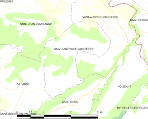
Saint-Martin-de-Vaulserre
- commune in Isère, France
Hiking in Saint-Martin-de-Vaulserre
Saint-Martin-de-Vaulserre is a charming commune located in the Isère department of the Auvergne-Rhône-Alpes region in southeastern France. The area offers various hiking opportunities that showcase the beautiful landscapes of the French Alps....
- Country:
- Postal Code: 38480
- Coordinates: 45° 29' 39" N, 5° 40' 58" E
- GPS tracks (wikiloc): [Link]
- Area: 3.92 sq km
- Population: 262
- Web site: [Link]


Saint-Jean-d'Avelanne
- commune in Isère, France
Hiking in Saint-Jean-d'Avelanne
Saint-Jean-d'Avelanne is a charming commune located in the Isère department of the Auvergne-Rhône-Alpes region in southeastern France. Surrounded by beautiful natural landscapes, it offers several opportunities for hiking and outdoor activities....
- Country:
- Postal Code: 38480
- Coordinates: 45° 30' 25" N, 5° 40' 23" E
- GPS tracks (wikiloc): [Link]
- Area: 7.85 sq km
- Population: 946
- Web site: [Link]


Saint-Bueil
- commune in Isère, France
Hiking in Saint-Bueil
Saint-Bueil is a charming village located in the Isère department of the Auvergne-Rhône-Alpes region in southeastern France. While it may not be as widely recognized as some other hiking destinations in the area, it offers beautiful landscapes and opportunities for outdoor activities, including hiking....
- Country:
- Postal Code: 38620
- Coordinates: 45° 28' 38" N, 5° 41' 23" E
- GPS tracks (wikiloc): [Link]
- Area: 3.81 sq km
- Population: 702


Pressins
- commune in Isère, France
Hiking in Pressins
Pressins is a charming commune located in the Isère department of southeastern France. It's a lesser-known destination for hikers, but it offers access to beautiful landscapes typical of the French Alps and surrounding regions. Here are some key points to consider if you're planning a hiking trip in and around Pressins:...
- Country:
- Postal Code: 38480
- Coordinates: 45° 31' 32" N, 5° 37' 38" E
- GPS tracks (wikiloc): [Link]
- Area: 10.1 sq km
- Population: 1147
- Web site: [Link]