Saint-Côme-du-Mont (Saint-Côme-du-Mont)

- former commune in Manche, France
- Country:

- Postal Code: 50500
- Coordinates: 49° 20' 9" N, 1° 16' 20" E


- GPS tracks (wikiloc): [Link]
- Area: 12.91 sq km
- Population: 515
- Wikipedia en: wiki(en)
- Wikipedia: wiki(fr)
- Wikidata storage: Wikidata: Q629927
- Wikipedia Commons Category: [Link]
- Freebase ID: [/m/03nxbml]
- Freebase ID: [/m/03nxbml]
- GeoNames ID: Alt: [6435573]
- GeoNames ID: Alt: [6435573]
- BnF ID: [15262432n]
- BnF ID: [15262432n]
- VIAF ID: Alt: [129485333]
- VIAF ID: Alt: [129485333]
- Library of Congress authority ID: Alt: [nr2006016713]
- Library of Congress authority ID: Alt: [nr2006016713]
- INSEE municipality code: 50458
- INSEE municipality code: 50458
Shares border with regions:


Auvers
- commune in Manche, France
- Country:
- Postal Code: 50500
- Coordinates: 49° 17' 46" N, 1° 19' 27" E
- GPS tracks (wikiloc): [Link]
- Area: 18.76 sq km
- Population: 674


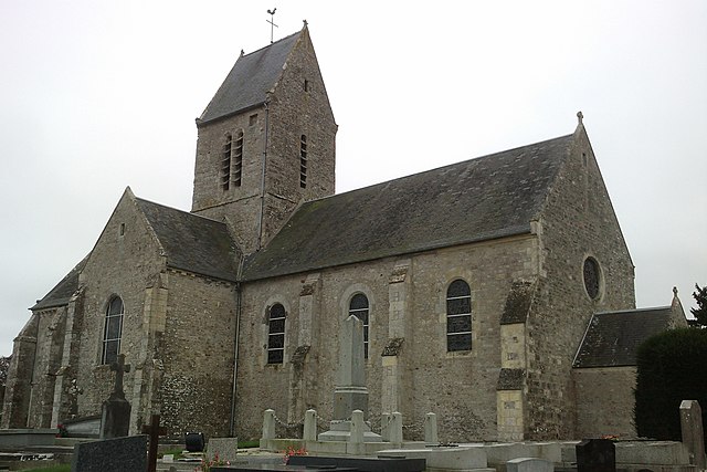
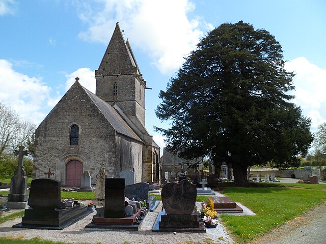
Saint-Hilaire-Petitville
- commune in Manche, France
- Country:
- Postal Code: 50500
- Coordinates: 49° 18' 14" N, 1° 13' 40" E
- GPS tracks (wikiloc): [Link]
- Area: 9.99 sq km
- Population: 1385
- Web site: [Link]

Brévands
- former commune in Manche, France
- Country:
- Postal Code: 50500
- Coordinates: 49° 19' 54" N, 1° 11' 0" E
- GPS tracks (wikiloc): [Link]
- Area: 13.87 sq km
- Population: 306

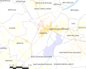
Carentan
- former commune in Manche, France
- Country:
- Postal Code: 50500
- Coordinates: 49° 18' 12" N, 1° 14' 54" E
- GPS tracks (wikiloc): [Link]
- AboveSeaLevel: 6 м m
- Area: 15.66 sq km
- Population: 5892
- Web site: [Link]

Angoville-au-Plain
- former commune in Manche, France
- Country:
- Postal Code: 50480
- Coordinates: 49° 20' 54" N, 1° 15' 15" E
- GPS tracks (wikiloc): [Link]
- Area: 5.68 sq km
- Population: 85


Houesville
- former commune in Manche, France
- Country:
- Postal Code: 50480
- Coordinates: 49° 21' 3" N, 1° 17' 16" E
- GPS tracks (wikiloc): [Link]
- Area: 5.38 sq km
- Population: 325


Appeville
- commune in Manche, France
- Country:
- Postal Code: 50500
- Coordinates: 49° 19' 18" N, 1° 20' 35" E
- GPS tracks (wikiloc): [Link]
- Area: 13.2 sq km
- Population: 177
- Web site: [Link]