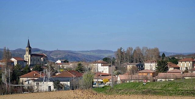
Saint-Donat-sur-l'Herbasse (Saint-Donat-sur-l'Herbasse)

- commune in Drôme, France
 Hiking in Saint-Donat-sur-l'Herbasse
Saint-Donat-sur-l'Herbasse is a charming commune located in the Drôme department in the Auvergne-Rhône-Alpes region of southeastern France. While it may not be as famous as some of the larger hiking destinations, it offers beautiful landscapes and a variety of trails suitable for hikers of all levels.
Hiking Opportunities:
-
Scenic Trails: The area around Saint-Donat-sur-l'Herbasse features a mix of forest paths, hills, and rolling countryside. These trails often provide stunning views of the surrounding hills and valleys.
-
Nature Walks: Many trails are suitable for nature walks, allowing hikers to enjoy the flora and fauna of the region. Look out for local wildlife and the diverse plant life, particularly in spring when everything is in bloom.
-
Local Heritage: Hiking in this area not only allows you to appreciate nature but also to discover local history and culture. Look for trails that may lead to historical sites or viewpoints.
Recommended Hiking Tips:
-
Check Trail Conditions: Before heading out, check the local conditions and trail maps. Some paths may be seasonal and require good weather to be navigable.
-
Pack Accordingly: Bring enough water, snacks, and appropriate gear. The weather can change quickly in these regions, so layers are a good idea.
-
Leave No Trace: As with all hiking, be sure to respect nature and the environment by following Leave No Trace principles.
-
Local Guides: If you're unfamiliar with the area, consider hiring a local guide who can provide insights into the trails, history, and best spots to explore.
Popular Hikes Nearby:
While there may not be specific renowned trails directly in Saint-Donat-sur-l'Herbasse, the surrounding areas, including the Tricastin and Vercors Regional Natural Parks, offer extensive hiking networks. These include varied terrain from flat plains to mountainous areas, suitable for different hiking experiences.
Remember to check local tourist information centers or online resources for updated trail maps, conditions, and possibly organized hiking events. Happy hiking!
- Country:

- Postal Code: 26260
- Coordinates: 45° 7' 23" N, 4° 58' 58" E


- GPS tracks (wikiloc): [Link]
- Area: 19.52 sq km
- Population: 4018
- Wikipedia en: wiki(en)
- Wikipedia: wiki(fr)
- Wikidata storage: Wikidata: Q1014924
- Wikipedia Commons Category: [Link]
- Freebase ID: [/m/03mhk6y]
- SIREN number: [212603013]
- BnF ID: [15253161f]
- VIAF ID: Alt: [238455804]
- MusicBrainz area ID: [495e60c8-c44e-4edc-aeea-b0a72302850b]
- INSEE municipality code: 26301
Shares border with regions:

Margès
- commune in Drôme, France
Hiking in Margès
Margès is a beautiful area in the Rhône-Alpes region of France, known for its stunning natural landscapes and rich biodiversity. Here are some key points to consider when hiking in Margès:...
- Country:
- Postal Code: 26260
- Coordinates: 45° 8' 49" N, 5° 2' 9" E
- GPS tracks (wikiloc): [Link]
- Area: 9.79 sq km
- Population: 1113

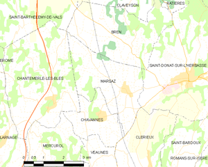
Marsaz
- commune in Drôme, France
Hiking in Marsaz
It seems there might be a misunderstanding regarding "Marsaz." If you meant "Marsa," a region in Malta, or if you are referring to a different location that sounds similar, please clarify....
- Country:
- Postal Code: 26260
- Coordinates: 45° 7' 2" N, 4° 56' 36" E
- GPS tracks (wikiloc): [Link]
- AboveSeaLevel: 281 м m
- Area: 8.95 sq km
- Population: 784


Saint-Bardoux
- commune in Drôme, France
Hiking in Saint-Bardoux
Saint-Bardoux, located in the Rhône-Alpes region of France, offers a variety of hiking opportunities for both beginners and experienced hikers. Here are some key points to consider when hiking in this picturesque area:...
- Country:
- Postal Code: 26260
- Coordinates: 45° 5' 8" N, 4° 58' 22" E
- GPS tracks (wikiloc): [Link]
- Area: 10.63 sq km
- Population: 600

Peyrins
- commune in Drôme, France
Hiking in Peyrins
Peyrins is a charming commune located in the Drôme department in southeastern France, nestled in the foothills of the French Alps. While it may not be as widely known as some of the larger hiking destinations in the region, Peyrins and its surrounding areas offer several scenic walking trails that cater to a range of hiking experiences....
- Country:
- Postal Code: 26380
- Coordinates: 45° 5' 35" N, 5° 2' 50" E
- GPS tracks (wikiloc): [Link]
- Area: 25.16 sq km
- Population: 2708


Bren
- commune in Drôme, France
Hiking in Bren
Bren is a charming commune located in the Drôme department in southeastern France, known for its stunning landscapes and outdoor activities, including hiking. The Drôme region offers a variety of hiking opportunities with diverse terrains, from gentle hills to more challenging trails through rugged scenery....
- Country:
- Postal Code: 26260
- Coordinates: 45° 8' 7" N, 4° 56' 54" E
- GPS tracks (wikiloc): [Link]
- Area: 11.03 sq km
- Population: 551


Clérieux
- commune in Drôme, France
Hiking in Clérieux
Clérieux is a charming commune located in the Drôme region of southeastern France. It offers a variety of hiking opportunities for outdoor enthusiasts looking to explore the beautiful natural landscape of the area. Here are some details about hiking in Clérieux:...
- Country:
- Postal Code: 26260
- Coordinates: 45° 4' 41" N, 4° 57' 34" E
- GPS tracks (wikiloc): [Link]
- Area: 13.53 sq km
- Population: 2021
- Web site: [Link]

Charmes-sur-l'Herbasse
- commune in Drôme, France
Hiking in Charmes-sur-l'Herbasse
Charmes-sur-l'Herbasse is a quaint village located in the Drôme department of southeastern France. It’s a wonderful location for hiking enthusiasts, offering a mix of beautiful landscapes, natural tranquility, and cultural sights. Here are some highlights for hiking in and around Charmes-sur-l'Herbasse:...
- Country:
- Postal Code: 26260
- Coordinates: 45° 8' 54" N, 5° 0' 58" E
- GPS tracks (wikiloc): [Link]
- Area: 12.84 sq km
- Population: 936


Ratières
- commune in Drôme, France
Hiking in Ratières
Ratières is a small village located in the Drôme department of the Auvergne-Rhône-Alpes region of France, not far from the Vercors Massif. It offers a peaceful environment surrounded by nature, making it an attractive spot for hiking enthusiasts. Here’s what you can expect when hiking in the area:...
- Country:
- Postal Code: 26330
- Coordinates: 45° 10' 54" N, 4° 58' 5" E
- GPS tracks (wikiloc): [Link]
- Area: 9.01 sq km
- Population: 268