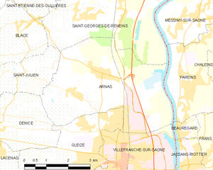
Saint-Georges-de-Reneins (Saint-Georges-de-Reneins)

- commune in Rhône, France
- Country:

- Postal Code: 69830
- Coordinates: 46° 3' 43" N, 4° 43' 18" E


- GPS tracks (wikiloc): [Link]
- Area: 27.49 sq km
- Population: 4359
- Web site: http://saintgeorgesdereneins.fr
- Wikipedia en: wiki(en)
- Wikipedia: wiki(fr)
- Wikidata storage: Wikidata: Q840216
- Wikipedia Commons Category: [Link]
- Freebase ID: [/m/03qggqm]
- Freebase ID: [/m/03qggqm]
- GeoNames ID: Alt: [6441766]
- GeoNames ID: Alt: [6441766]
- SIREN number: [216902064]
- SIREN number: [216902064]
- BnF ID: [15272294v]
- BnF ID: [15272294v]
- VIAF ID: Alt: [152715052]
- VIAF ID: Alt: [152715052]
- Library of Congress authority ID: Alt: [no00026470]
- Library of Congress authority ID: Alt: [no00026470]
- INSEE municipality code: 69206
- INSEE municipality code: 69206
Shares border with regions:


Charentay
- commune in Rhône, France
- Country:
- Postal Code: 69220
- Coordinates: 46° 5' 20" N, 4° 40' 45" E
- GPS tracks (wikiloc): [Link]
- Area: 13.78 sq km
- Population: 1240
- Web site: [Link]


Saint-Étienne-des-Oullières
- commune in Rhône, France
- Country:
- Postal Code: 69460
- Coordinates: 46° 4' 2" N, 4° 38' 58" E
- GPS tracks (wikiloc): [Link]
- Area: 9.66 sq km
- Population: 2175
- Web site: [Link]

Arnas
- commune in Rhône, France
- Country:
- Postal Code: 69400
- Coordinates: 46° 1' 25" N, 4° 42' 30" E
- GPS tracks (wikiloc): [Link]
- Area: 17.52 sq km
- Population: 3594
- Web site: [Link]


Blacé
- commune in Rhône, France
- Country:
- Postal Code: 69460
- Coordinates: 46° 1' 53" N, 4° 38' 40" E
- GPS tracks (wikiloc): [Link]
- Area: 11 sq km
- Population: 1535


Saint-Julien, Rhône
- commune in Rhône, France
- Country:
- Postal Code: 69640
- Coordinates: 46° 1' 34" N, 4° 39' 8" E
- GPS tracks (wikiloc): [Link]
- Area: 6.89 sq km
- Population: 829


Belleville
- commune in Rhône, France
- Country:
- Postal Code: 69220
- Coordinates: 46° 6' 31" N, 4° 44' 57" E
- GPS tracks (wikiloc): [Link]
- Area: 10.42 sq km
- Population: 8293
- Web site: [Link]
Fareins
- commune in Ain, France
- Country:
- Postal Code: 01480
- Coordinates: 46° 1' 10" N, 4° 45' 42" E
- GPS tracks (wikiloc): [Link]
- Area: 8.22 sq km
- Population: 2192
- Web site: [Link]

Messimy-sur-Saône
- commune in Ain, France
- Country:
- Postal Code: 01480
- Coordinates: 46° 2' 54" N, 4° 45' 53" E
- GPS tracks (wikiloc): [Link]
- Area: 5.95 sq km
- Population: 1218
- Web site: [Link]

Montmerle-sur-Saône
- commune in Ain, France
- Country:
- Postal Code: 01090
- Coordinates: 46° 4' 53" N, 4° 45' 31" E
- GPS tracks (wikiloc): [Link]
- Area: 4.16 sq km
- Population: 3794
- Web site: [Link]
Lurcy
- commune in Ain, France
- Country:
- Postal Code: 01090
- Coordinates: 46° 3' 46" N, 4° 46' 52" E
- GPS tracks (wikiloc): [Link]
- Area: 4.81 sq km
- Population: 387
- Web site: [Link]