Saint-Hilaire (Saint-Hilaire)

- commune in Isère, France
 Hiking in Saint-Hilaire
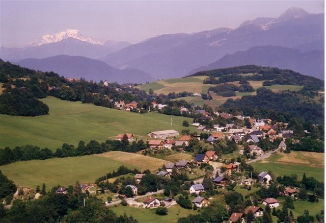
Saint-Hilaire, located in the Isère department of the Auvergne-Rhône-Alpes region in southeastern France, is a popular destination for hiking and outdoor activities. The area is renowned for its stunning landscapes, featuring a mix of mountains, forests, and scenic viewpoints, making it a fantastic spot for all levels of hikers.
Key Hiking Areas and Trails
-
Chartreuse Mountains: The nearby Chartreuse Mountains offer a range of hiking trails with varying difficulty levels. You can find both gentle walks and more challenging paths leading to panoramic viewpoints.
-
Col de la Petite Sure: This area features several trails that take you through the beautiful alpine scenery and offer stunning views of the surrounding mountains.
-
Paragliding and Hiking: Saint-Hilaire is also known for paragliding. Many hikers combine their experience with this thrilling activity, as the take-off sites are often located along popular hiking routes.
-
Nature Reserves: The region includes protected areas where you can discover local flora and fauna. Trails in these ecological zones provide visitors with a unique chance to observe wildlife and enjoy the natural beauty of the landscape.
Practical Tips
-
Trail Maps: It's essential to carry a map or use a GPS device, as trails can vary in marking and difficulty. The local tourism office can provide maps and information about recommended trails.
-
Weather Conditions: The weather can change rapidly in mountainous areas, so check forecasts before heading out and be prepared for all conditions.
-
Safety Precautions: Always inform someone of your hiking plans, carry enough water and snacks, and bring a first-aid kit. Phone signals may be weak in remote areas, so plan accordingly.
-
Guided Tours: If you're unfamiliar with the area, consider joining a guided hiking tour. Local guides can provide insights about the terrain, history, and wildlife.
-
Seasonal Considerations: Summer and early fall are ideal for hiking due to comfortable temperatures and clearer trails. However, some trails may be accessible year-round, while others may require technical gear in winter months.
Saint-Hilaire offers a harmonious blend of adventure and natural beauty, making it an excellent spot for both seasoned hikers and families looking for a day out in nature. Be sure to enjoy the breathtaking views and the rich biodiversity the region has to offer!
- Country:

- Postal Code: 38660
- Coordinates: 45° 18' 34" N, 5° 53' 14" E


- GPS tracks (wikiloc): [Link]
- Area: 8.61 sq km
- Population: 1348
- Web site: http://www.sainthilairedutouvet.com
- Wikipedia en: wiki(en)
- Wikipedia: wiki(fr)
- Wikidata storage: Wikidata: Q670702
- Wikipedia Commons Category: [Link]
- Freebase ID: [/m/02phwz7]
- GeoNames ID: Alt: [2979574]
- SIREN number: [213803950]
- BnF ID: [15258205f]
- VIAF ID: Alt: [144397228]
- Library of Congress authority ID: Alt: [n93054483]
- MusicBrainz area ID: [bef44916-5996-456a-9695-2d28d22bd547]
- INSEE municipality code: 38395
Shares border with regions:

Saint-Pancrasse
- commune in Isère, France
Hiking in Saint-Pancrasse
Saint-Pancrasse is a charming village located in the Isère department of the Auvergne-Rhône-Alpes region in southeastern France. Nestled in the foothills of the French Alps, it offers stunning scenery and a variety of hiking opportunities suitable for different skill levels....
- Country:
- Postal Code: 38660
- Coordinates: 45° 17' 31" N, 5° 51' 35" E
- GPS tracks (wikiloc): [Link]
- Area: 6.71 sq km
- Population: 442


Lumbin
- commune in Isère, France
Hiking in Lumbin
Lumbini, located in Nepal, is primarily known as the birthplace of Siddhartha Gautama, who became the Buddha. While it is mainly a pilgrimage site, it also offers a serene environment for hiking and exploring the natural beauty surrounding the area....
- Country:
- Postal Code: 38660
- Coordinates: 45° 18' 24" N, 5° 54' 45" E
- GPS tracks (wikiloc): [Link]
- Area: 6.77 sq km
- Population: 2143
- Web site: [Link]


Crolles
- commune in Isère, France
Hiking in Crolles
Crolles is a charming town located in the Auvergne-Rhône-Alpes region of France, nestled in the foothills of the Chartreuse mountains. It's a fantastic destination for hiking enthusiasts due to its stunning landscapes, diverse trails, and proximity to nature reserves....
- Country:
- Postal Code: 38920
- Coordinates: 45° 17' 6" N, 5° 52' 58" E
- GPS tracks (wikiloc): [Link]
- Area: 14.21 sq km
- Population: 8345
- Web site: [Link]

Saint-Pierre-de-Chartreuse
- commune in Isère, France
Hiking in Saint-Pierre-de-Chartreuse
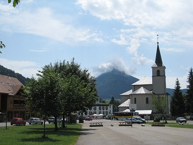
Saint-Pierre-de-Chartreuse is a picturesque village located in the Chartreuse Mountains, in the Auvergne-Rhône-Alpes region of France. It's a popular destination for outdoor enthusiasts, particularly hikers, due to its stunning landscapes, diverse trails, and rich natural heritage. Here are some highlights and tips for hiking in this beautiful area:...
- Country:
- Postal Code: 38380
- Coordinates: 45° 20' 33" N, 5° 48' 56" E
- GPS tracks (wikiloc): [Link]
- Area: 80.12 sq km
- Population: 1028
- Web site: [Link]

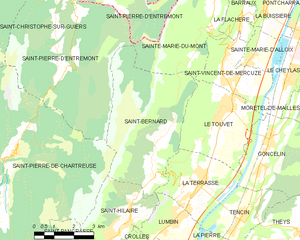
Saint-Bernard
- commune in Isère, France
Hiking in Saint-Bernard
Hiking in Saint-Bernard, Isère, offers numerous trails and breathtaking views that showcase the stunning landscape of the French Alps. The region is characterized by its diverse terrain, which includes mountains, forests, and valleys that provide a variety of hiking experiences for all skill levels....
- Country:
- Postal Code: 38660
- Coordinates: 45° 19' 46" N, 5° 54' 12" E
- GPS tracks (wikiloc): [Link]
- Area: 21.59 sq km
- Population: 623
- Web site: [Link]


La Terrasse
- commune in Isère, France
Hiking in La Terrasse
La Terrasse is a charming town in the Auvergne-Rhône-Alpes region of France, known for its picturesque landscapes and access to various hiking trails. Here are some aspects to consider if you're planning to hike in La Terrasse:...
- Country:
- Postal Code: 38660
- Coordinates: 45° 19' 25" N, 5° 55' 52" E
- GPS tracks (wikiloc): [Link]
- Area: 9.47 sq km
- Population: 2567
- Web site: [Link]