Saint-Hilaire-de-Gondilly (Saint-Hilaire-de-Gondilly)

- commune in Cher, France
- Country:

- Postal Code: 18320
- Coordinates: 47° 2' 58" N, 2° 53' 10" E


- GPS tracks (wikiloc): [Link]
- Area: 18.42 sq km
- Population: 177
- Wikipedia en: wiki(en)
- Wikipedia: wiki(fr)
- Wikidata storage: Wikidata: Q1173571
- Wikipedia Commons Category: [Link]
- Freebase ID: [/m/03mfdz5]
- GeoNames ID: Alt: [6428276]
- SIREN number: [211802152]
- BnF ID: [15249561s]
- INSEE municipality code: 18215
Shares border with regions:

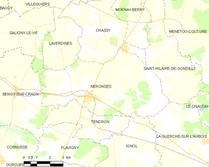
Nérondes
- commune in Cher, France
- Country:
- Postal Code: 18350
- Coordinates: 46° 59' 51" N, 2° 49' 10" E
- GPS tracks (wikiloc): [Link]
- Area: 34 sq km
- Population: 1526
- Web site: [Link]
Le Chautay
- commune in Cher, France
- Country:
- Postal Code: 18150
- Coordinates: 46° 58' 37" N, 2° 58' 0" E
- GPS tracks (wikiloc): [Link]
- Area: 14.74 sq km
- Population: 304


La Guerche-sur-l'Aubois
- commune in Cher, France
- Country:
- Postal Code: 18150
- Coordinates: 46° 57' 4" N, 2° 56' 51" E
- GPS tracks (wikiloc): [Link]
- Area: 52.7 sq km
- Population: 3322
- Web site: [Link]


Mornay-Berry
- commune in Cher, France
- Country:
- Postal Code: 18350
- Coordinates: 47° 2' 56" N, 2° 52' 16" E
- GPS tracks (wikiloc): [Link]
- Area: 9.15 sq km
- Population: 188


Menetou-Couture
- commune in Cher, France
- Country:
- Postal Code: 18320
- Coordinates: 47° 2' 43" N, 2° 54' 52" E
- GPS tracks (wikiloc): [Link]
- Area: 28.93 sq km
- Population: 356
- Web site: [Link]


Chassy
- commune in Cher, France
- Country:
- Postal Code: 18800
- Coordinates: 47° 2' 31" N, 2° 50' 10" E
- GPS tracks (wikiloc): [Link]
- Area: 17.76 sq km
- Population: 250

Garigny
- commune in Cher, France
- Country:
- Postal Code: 18140
- Coordinates: 47° 5' 13" N, 2° 53' 16" E
- GPS tracks (wikiloc): [Link]
- Area: 19.66 sq km
- Population: 260