Saint-Hilaire-de-la-Noaille (Saint-Hilaire-de-la-Noaille)

- commune in Gironde, France
- Country:

- Postal Code: 33190
- Coordinates: 44° 36' 4" N, 0° 0' 6" E


- GPS tracks (wikiloc): [Link]
- Area: 11.45 sq km
- Population: 382
- Wikipedia en: wiki(en)
- Wikipedia: wiki(fr)
- Wikidata storage: Wikidata: Q202147
- Wikipedia Commons Category: [Link]
- Freebase ID: [/m/03ns1c0]
- GeoNames ID: Alt: [6432405]
- SIREN number: [213304181]
- BnF ID: [152564672]
- INSEE municipality code: 33418
Shares border with regions:


Fossès-et-Baleyssac
- commune in Gironde, France
- Country:
- Postal Code: 33190
- Coordinates: 44° 35' 39" N, 0° 2' 31" E
- GPS tracks (wikiloc): [Link]
- Area: 9.4 sq km
- Population: 209


La Réole
- commune in Gironde, France
- Country:
- Postal Code: 33190
- Coordinates: 44° 34' 52" N, 0° 2' 28" E
- GPS tracks (wikiloc): [Link]
- Area: 12.53 sq km
- Population: 4173
- Web site: [Link]


Saint-Sève
- commune in Gironde, France
- Country:
- Postal Code: 33190
- Coordinates: 44° 36' 35" N, 0° 1' 45" E
- GPS tracks (wikiloc): [Link]
- Area: 4.8 sq km
- Population: 245

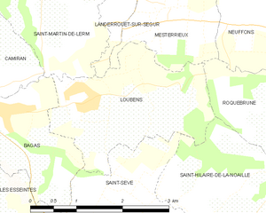
Loubens
- commune in Gironde, France
- Country:
- Postal Code: 33190
- Coordinates: 44° 37' 48" N, 0° 2' 13" E
- GPS tracks (wikiloc): [Link]
- Area: 5.89 sq km
- Population: 301


Mongauzy
- commune in Gironde, France
- Country:
- Postal Code: 33190
- Coordinates: 44° 34' 2" N, 0° 2' 1" E
- GPS tracks (wikiloc): [Link]
- Area: 6.84 sq km
- Population: 601


Montagoudin
- commune in Gironde, France
- Country:
- Postal Code: 33190
- Coordinates: 44° 34' 40" N, 0° 0' 1" E
- GPS tracks (wikiloc): [Link]
- AboveSeaLevel: 150 м m
- Area: 3.34 sq km
- Population: 186
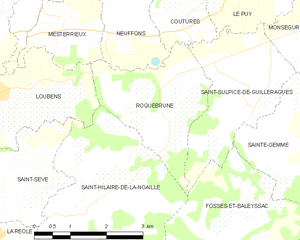
Roquebrune
- commune in Gironde, France
- Country:
- Postal Code: 33580
- Coordinates: 44° 37' 45" N, 0° 1' 20" E
- GPS tracks (wikiloc): [Link]
- Area: 6.52 sq km
- Population: 267
- Web site: [Link]