Fossès-et-Baleyssac (Fossès-et-Baleyssac)

- commune in Gironde, France
- Country:

- Postal Code: 33190
- Coordinates: 44° 35' 39" N, 0° 2' 31" E


- GPS tracks (wikiloc): [Link]
- Area: 9.4 sq km
- Population: 209
- Wikipedia en: wiki(en)
- Wikipedia: wiki(fr)
- Wikidata storage: Wikidata: Q194218
- Wikipedia Commons Category: [Link]
- Freebase ID: [/m/03nrzg8]
- GeoNames ID: Alt: [6613620]
- SIREN number: [213301716]
- BnF ID: [15256223w]
- INSEE municipality code: 33171
Shares border with regions:

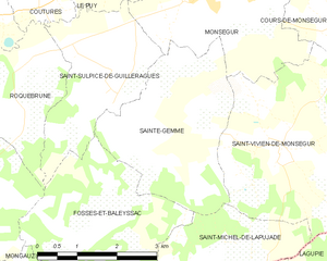
Sainte-Gemme
- commune in Gironde, France
- Country:
- Postal Code: 33580
- Coordinates: 44° 37' 13" N, 0° 4' 11" E
- GPS tracks (wikiloc): [Link]
- Area: 9.55 sq km
- Population: 202


Saint-Hilaire-de-la-Noaille
- commune in Gironde, France
- Country:
- Postal Code: 33190
- Coordinates: 44° 36' 4" N, 0° 0' 6" E
- GPS tracks (wikiloc): [Link]
- Area: 11.45 sq km
- Population: 382


Saint-Sulpice-de-Guilleragues
- commune in Gironde, France
- Country:
- Postal Code: 33580
- Coordinates: 44° 37' 45" N, 0° 3' 0" E
- GPS tracks (wikiloc): [Link]
- AboveSeaLevel: 61 м m
- Area: 6.89 sq km
- Population: 226


Mongauzy
- commune in Gironde, France
- Country:
- Postal Code: 33190
- Coordinates: 44° 34' 2" N, 0° 2' 1" E
- GPS tracks (wikiloc): [Link]
- Area: 6.84 sq km
- Population: 601


Saint-Michel-de-Lapujade
- commune in Gironde, France
- Country:
- Postal Code: 33190
- Coordinates: 44° 34' 54" N, 0° 4' 14" E
- GPS tracks (wikiloc): [Link]
- AboveSeaLevel: 85 м m
- Area: 7.47 sq km
- Population: 225
- Web site: [Link]
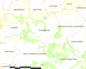
Roquebrune
- commune in Gironde, France
- Country:
- Postal Code: 33580
- Coordinates: 44° 37' 45" N, 0° 1' 20" E
- GPS tracks (wikiloc): [Link]
- Area: 6.52 sq km
- Population: 267
- Web site: [Link]