Saint-Jean-aux-Amognes (Saint-Jean-aux-Amognes)

- commune in Nièvre, France
- Country:

- Postal Code: 58270
- Coordinates: 47° 0' 56" N, 3° 20' 5" E


- GPS tracks (wikiloc): [Link]
- Area: 18.02 sq km
- Population: 509
- Wikipedia en: wiki(en)
- Wikipedia: wiki(fr)
- Wikidata storage: Wikidata: Q1146892
- Wikipedia Commons Category: [Link]
- Freebase ID: [/m/03qffm1]
- GeoNames ID: Alt: [6438076]
- SIREN number: [215802471]
- BnF ID: [152665128]
- PACTOLS thesaurus ID: [pcrtXWlypRkP7u]
- INSEE municipality code: 58247
Shares border with regions:


Montigny-aux-Amognes
- commune in Nièvre, France
- Country:
- Postal Code: 58130
- Coordinates: 47° 1' 39" N, 3° 17' 24" E
- GPS tracks (wikiloc): [Link]
- Area: 25.17 sq km
- Population: 588


Sauvigny-les-Bois
- commune in Nièvre, France
- Country:
- Postal Code: 58160
- Coordinates: 46° 58' 7" N, 3° 16' 21" E
- GPS tracks (wikiloc): [Link]
- Area: 29.64 sq km
- Population: 1489

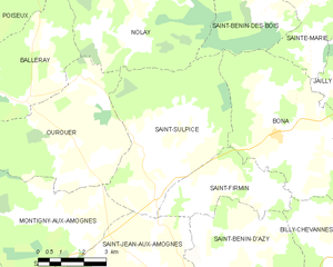
Saint-Sulpice
- commune in Nièvre, France
- Country:
- Postal Code: 58270
- Coordinates: 47° 3' 20" N, 3° 20' 51" E
- GPS tracks (wikiloc): [Link]
- Area: 25.71 sq km
- Population: 415


Saint-Firmin
- commune in Nièvre, France
- Country:
- Postal Code: 58270
- Coordinates: 47° 2' 36" N, 3° 23' 30" E
- GPS tracks (wikiloc): [Link]
- Area: 10.4 sq km
- Population: 181

Saint-Benin-d'Azy
- commune in Nièvre, France
- Country:
- Postal Code: 58270
- Coordinates: 46° 59' 58" N, 3° 23' 34" E
- GPS tracks (wikiloc): [Link]
- Area: 35.8 sq km
- Population: 1286
La Fermeté
- commune in Nièvre, France
- Country:
- Postal Code: 58160
- Coordinates: 46° 57' 59" N, 3° 20' 0" E
- GPS tracks (wikiloc): [Link]
- Area: 36.02 sq km
- Population: 697