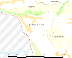
Saint-Jean-le-Thomas (Saint-Jean-le-Thomas)
- commune in Manche, France
- Country:

- Postal Code: 50530
- Coordinates: 48° 43' 48" N, 1° 31' 1" E


- GPS tracks (wikiloc): [Link]
- Area: 2.38 sq km
- Population: 423
- Wikipedia en: wiki(en)
- Wikipedia: wiki(fr)
- Wikidata storage: Wikidata: Q545535
- Wikipedia Commons Category: [Link]
- Freebase ID: [/m/03x_zld]
- Freebase ID: [/m/03x_zld]
- GeoNames ID: Alt: [2979215]
- GeoNames ID: Alt: [2979215]
- SIREN number: [215004961]
- SIREN number: [215004961]
- BnF ID: [152624690]
- BnF ID: [152624690]
- PACTOLS thesaurus ID: [pcrt9fNmtlEMlu]
- PACTOLS thesaurus ID: [pcrt9fNmtlEMlu]
- INSEE municipality code: 50496
- INSEE municipality code: 50496
Shares border with regions:


Champeaux
- commune in Manche, France
- Country:

- Postal Code: 50530
- Coordinates: 48° 44' 20" N, 1° 31' 43" E


- GPS tracks (wikiloc): [Link]
- Area: 4.29 sq km
- Population: 361
- Web site: [Link]


Dragey-Ronthon
- commune in Manche, France
- Country:

- Postal Code: 50530
- Coordinates: 48° 43' 0" N, 1° 30' 0" E


- GPS tracks (wikiloc): [Link]
- AboveSeaLevel: 40 м m
- Area: 15.17 sq km
- Population: 817
- Web site: [Link]
