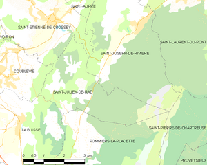
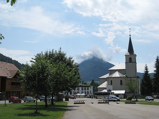
Saint-Joseph-de-Rivière (Saint-Joseph-de-Rivière)
- commune in Isère, France
 Hiking in Saint-Joseph-de-Rivière
Saint-Joseph-de-Rivière is a charming village located in the Isère department in the Auvergne-Rhône-Alpes region of France. This area is surrounded by beautiful natural landscapes, making it an appealing destination for hiking enthusiasts.
Hiking Opportunities:
-
Scenic Trails: The region offers a variety of hiking trails that range from easy walks to more challenging hikes. The trails often provide stunning views of the surrounding mountains, valleys, and rivers.
-
Vercors Regional Natural Park: Just a short drive from Saint-Joseph-de-Rivière, you can access some of the trails in the Vercors Massif, which is known for its dramatic cliffs, deep gorges, and diverse flora and fauna. The park offers numerous hiking paths suited for different skill levels.
-
Local Trails: Within Saint-Joseph-de-Rivière itself, there are local trails that take you through picturesque landscapes, past charming villages, and through lush forests. Make sure to observe the local wildlife and plant species along the way.
-
Top Hikes: If you're looking for recommendations, consider the trails leading up to the Pic Saint-Michel or the routes around the Gorges de la Bourne. Each of these spots offers remarkable views and unique geological features.
Tips for Hiking in Saint-Joseph-de-Rivière:
- Prepare for Varying Conditions: The weather in the region can change quickly, so bring appropriate clothing layers and rain gear.
- Stay Hydrated and Nourished: Carry enough water and snacks, especially if you're planning a longer hike.
- Check Map and Trail Conditions: Before you head out, check local resources for maps and trail conditions; it's also a good idea to inform someone of your planned route.
- Respect Nature: Follow Leave No Trace principles to preserve the beauty of the area.
Nearby Amenities:
In addition to hiking, Saint-Joseph-de-Rivière has local amenities such as small shops, cafes, and accommodations where you can relax and enjoy the local culture after your hiking adventures.
With its breathtaking surroundings and diverse hiking options, Saint-Joseph-de-Rivière is a wonderful destination for outdoor lovers. Enjoy exploring the trails and the beauty of the Alps!
- Country:

- Postal Code: 38134
- Coordinates: 45° 22' 33" N, 5° 41' 49" E


- GPS tracks (wikiloc): [Link]
- Area: 17.39 sq km
- Population: 1218
- Web site: http://www.saint-joseph-de-riviere.fr
- Wikipedia en: wiki(en)
- Wikipedia: wiki(fr)
- Wikidata storage: Wikidata: Q779873
- Wikipedia Commons Category: [Link]
- Freebase ID: [/m/03nvgym]
- SIREN number: [213804057]
- BnF ID: [15258215r]
- VIAF ID: Alt: [316738474]
- INSEE municipality code: 38405
Shares border with regions:


Saint-Étienne-de-Crossey
- commune in Isère, France
 Hiking in Saint-Étienne-de-Crossey
Saint-Étienne-de-Crossey is a charming commune located in the Isère department of the Auvergne-Rhône-Alpes region in southeastern France. It is surrounded by stunning natural landscapes, making it a great destination for hiking enthusiasts. Here are some highlights and tips for hiking in this area:...
- Country:

- Postal Code: 38960
- Coordinates: 45° 22' 45" N, 5° 38' 44" E


- GPS tracks (wikiloc): [Link]
- Area: 12.84 sq km
- Population: 2550
- Web site: [Link]


Saint-Julien-de-Raz
- former commune in Isère, France
Saint-Julien-de-Raz is a charming commune in the Vaucluse department of the Provence-Alpes-Côte d'Azur region in southeastern France. Although it's not widely known as a major hiking destination, it offers access to beautiful natural surroundings that are ideal for those interested in exploring the great outdoors....
- Country:

- Postal Code: 38134
- Coordinates: 45° 20' 59" N, 5° 39' 42" E


- GPS tracks (wikiloc): [Link]
- AboveSeaLevel: 630 м m
- Area: 10.81 sq km
- Population: 429
- Web site: [Link]


Miribel-les-Échelles
- commune in Isère, France
 Hiking in Miribel-les-Échelles
Miribel-les-Échelles is a charming village located in the Isère department of the Auvergne-Rhône-Alpes region in southeastern France. It is nestled in the foothills of the Chartreuse Mountains, providing a stunning backdrop for various outdoor activities, including hiking....
- Country:

- Postal Code: 38380
- Coordinates: 45° 25' 45" N, 5° 42' 30" E


- GPS tracks (wikiloc): [Link]
- Area: 29.34 sq km
- Population: 1720


Saint-Aupre
- commune in Isère, France
Saint-Aupre is a charming commune located in the Isère department in the Auvergne-Rhône-Alpes region of France. It's surrounded by stunning natural landscapes, making it an excellent destination for hiking enthusiasts....
- Country:

- Postal Code: 38960
- Coordinates: 45° 23' 58" N, 5° 40' 14" E


- GPS tracks (wikiloc): [Link]
- Area: 11.93 sq km
- Population: 1123
- Web site: [Link]


Saint-Laurent-du-Pont
- commune in Isère, France
 Hiking in Saint-Laurent-du-Pont
Saint-Laurent-du-Pont is a charming commune located in the Isère department of the Auvergne-Rhône-Alpes region in France. It is surrounded by stunning natural landscapes, including the Chartreuse Mountains, making it an excellent destination for hiking enthusiasts....
- Country:

- Postal Code: 38380
- Coordinates: 45° 23' 15" N, 5° 44' 5" E


- GPS tracks (wikiloc): [Link]
- Area: 35.25 sq km
- Population: 4543
- Web site: [Link]


Saint-Pierre-de-Chartreuse
- commune in Isère, France
 Hiking in Saint-Pierre-de-Chartreuse
Saint-Pierre-de-Chartreuse is a picturesque village located in the Chartreuse Mountains, in the Auvergne-Rhône-Alpes region of France. It's a popular destination for outdoor enthusiasts, particularly hikers, due to its stunning landscapes, diverse trails, and rich natural heritage. Here are some highlights and tips for hiking in this beautiful area:...
- Country:

- Postal Code: 38380
- Coordinates: 45° 20' 33" N, 5° 48' 56" E


- GPS tracks (wikiloc): [Link]
- Area: 80.12 sq km
- Population: 1028
- Web site: [Link]
