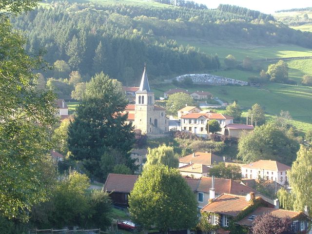
Saint-Just-en-Chevalet (Saint-Just-en-Chevalet)

- commune in Loire, France
- Country:

- Postal Code: 42430
- Coordinates: 45° 54' 49" N, 3° 50' 45" E


- GPS tracks (wikiloc): [Link]
- Area: 29.19 sq km
- Population: 1148
- Web site: http://www.st-just-en-chevalet.com
- Wikipedia en: wiki(en)
- Wikipedia: wiki(fr)
- Wikidata storage: Wikidata: Q1106348
- Wikipedia Commons Category: [Link]
- Freebase ID: [/m/03nw8t2]
- Freebase ID: [/m/03nw8t2]
- GeoNames ID: Alt: [6434284]
- GeoNames ID: Alt: [6434284]
- SIREN number: [214202483]
- SIREN number: [214202483]
- BnF ID: [15259815n]
- BnF ID: [15259815n]
- INSEE municipality code: 42248
- INSEE municipality code: 42248
Shares border with regions:


La Tuilière
- commune in Loire, France
- Country:
- Postal Code: 42830
- Coordinates: 45° 56' 41" N, 3° 48' 6" E
- GPS tracks (wikiloc): [Link]
- Area: 31.09 sq km
- Population: 287
Saint-Romain-d'Urfé
- commune in Loire, France
- Country:
- Postal Code: 42430
- Coordinates: 45° 53' 14" N, 3° 49' 40" E
- GPS tracks (wikiloc): [Link]
- Area: 15 sq km
- Population: 267
- Web site: [Link]


Saint-Priest-la-Prugne
- commune in Loire, France
- Country:
- Postal Code: 42830
- Coordinates: 45° 57' 39" N, 3° 44' 59" E
- GPS tracks (wikiloc): [Link]
- Area: 36.68 sq km
- Population: 436
Juré
- commune in Loire, France
- Country:
- Postal Code: 42430
- Coordinates: 45° 53' 2" N, 3° 53' 29" E
- GPS tracks (wikiloc): [Link]
- Area: 12.07 sq km
- Population: 237
- Web site: [Link]


Saint-Marcel-d'Urfé
- commune in Loire, France
- Country:
- Postal Code: 42430
- Coordinates: 45° 52' 22" N, 3° 53' 6" E
- GPS tracks (wikiloc): [Link]
- Area: 13.92 sq km
- Population: 296

Cherier
- commune in Loire, France
- Country:
- Postal Code: 42430
- Coordinates: 45° 57' 53" N, 3° 54' 34" E
- GPS tracks (wikiloc): [Link]
- Area: 28.11 sq km
- Population: 532

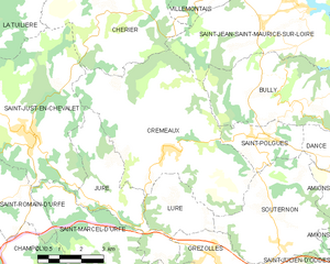
Cremeaux
- commune in Loire, France
- Country:
- Postal Code: 42260
- Coordinates: 45° 54' 28" N, 3° 55' 42" E
- GPS tracks (wikiloc): [Link]
- Area: 33.32 sq km
- Population: 911
Chausseterre
- commune in Loire, France
- Country:
- Postal Code: 42430
- Coordinates: 45° 53' 47" N, 3° 47' 1" E
- GPS tracks (wikiloc): [Link]
- Area: 16.58 sq km
- Population: 238