Saint-Laurent-Rochefort (Saint-Laurent-Rochefort)

- commune in Loire, France
- Country:

- Postal Code: 42130
- Coordinates: 45° 46' 24" N, 3° 55' 24" E


- GPS tracks (wikiloc): [Link]
- Area: 15.6 sq km
- Population: 242
- Web site: http://www.saint-laurent-rochefort.com/
- Wikipedia en: wiki(en)
- Wikipedia: wiki(fr)
- Wikidata storage: Wikidata: Q981060
- Wikipedia Commons Category: [Link]
- Freebase ID: [/m/03nw8v3]
- Freebase ID: [/m/03nw8v3]
- GeoNames ID: Alt: [6434287]
- GeoNames ID: Alt: [6434287]
- SIREN number: [214202525]
- SIREN number: [214202525]
- BnF ID: [152598191]
- BnF ID: [152598191]
- VIAF ID: Alt: [238100248]
- VIAF ID: Alt: [238100248]
- INSEE municipality code: 42252
- INSEE municipality code: 42252
Shares border with regions:

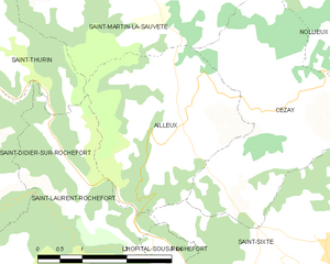
Ailleux
- commune in Loire, France
- Country:
- Postal Code: 42130
- Coordinates: 45° 48' 13" N, 3° 56' 33" E
- GPS tracks (wikiloc): [Link]
- Area: 9.31 sq km
- Population: 152

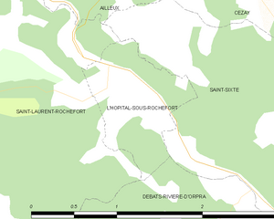
L'Hôpital-sous-Rochefort
- commune in Loire, France
- Country:
- Postal Code: 42130
- Coordinates: 45° 46' 26" N, 3° 56' 1" E
- GPS tracks (wikiloc): [Link]
- AboveSeaLevel: 427 м m
- Area: 1.15 sq km
- Population: 112
- Web site: [Link]


Saint-Sixte
- commune in Loire, France
- Country:
- Postal Code: 42130
- Coordinates: 45° 46' 33" N, 3° 58' 56" E
- GPS tracks (wikiloc): [Link]
- Area: 15.35 sq km
- Population: 722
- Web site: [Link]


Saint-Just-en-Bas
- commune in Loire, France
- Country:
- Postal Code: 42136
- Coordinates: 45° 43' 51" N, 3° 52' 50" E
- GPS tracks (wikiloc): [Link]
- Area: 20.95 sq km
- Population: 291
Saint-Thurin
- commune in Loire, France
- Country:
- Postal Code: 42111
- Coordinates: 45° 48' 58" N, 3° 52' 18" E
- GPS tracks (wikiloc): [Link]
- Area: 7.35 sq km
- Population: 188
Saint-Didier-sur-Rochefort
- commune in Loire, France
- Country:
- Postal Code: 42111
- Coordinates: 45° 47' 36" N, 3° 50' 42" E
- GPS tracks (wikiloc): [Link]
- Area: 22.75 sq km
- Population: 405
Débats-Rivière-d'Orpra
- commune in Loire, France
- Country:
- Postal Code: 42130
- Coordinates: 45° 45' 36" N, 3° 56' 19" E
- GPS tracks (wikiloc): [Link]
- AboveSeaLevel: 425 м m
- Area: 3.41 sq km
- Population: 155


Palogneux
- commune in Loire, France
- Country:
- Postal Code: 42990
- Coordinates: 45° 44' 38" N, 3° 55' 12" E
- GPS tracks (wikiloc): [Link]
- Area: 7.01 sq km
- Population: 78