Saint-Maixent (Saint-Maixent)

- commune in Sarthe, France
- Country:

- Postal Code: 72320
- Coordinates: 48° 5' 22" N, 0° 39' 6" E


- GPS tracks (wikiloc): [Link]
- Area: 22.48 sq km
- Population: 721
- Wikipedia en: wiki(en)
- Wikipedia: wiki(fr)
- Wikidata storage: Wikidata: Q1233867
- Wikipedia Commons Category: [Link]
- Freebase ID: [/m/08_01p]
- GeoNames ID: Alt: [6454644]
- SIREN number: [217202969]
- BnF ID: [15273848k]
- VIAF ID: Alt: [125185042]
- PACTOLS thesaurus ID: [pcrtykZZKdrJTJ]
- INSEE municipality code: 72296
Shares border with regions:

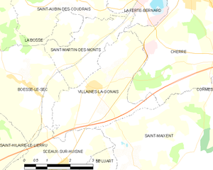
Villaines-la-Gonais
- commune in Sarthe, France
- Country:
- Postal Code: 72400
- Coordinates: 48° 8' 10" N, 0° 36' 6" E
- GPS tracks (wikiloc): [Link]
- Area: 10.34 sq km
- Population: 556
- Web site: [Link]

Lavaré
- commune in Sarthe, France
- Country:
- Postal Code: 72390
- Coordinates: 48° 3' 12" N, 0° 38' 41" E
- GPS tracks (wikiloc): [Link]
- Area: 22.88 sq km
- Population: 842


Sceaux-sur-Huisne
- commune in Sarthe, France
- Country:
- Postal Code: 72160
- Coordinates: 48° 6' 17" N, 0° 35' 0" E
- GPS tracks (wikiloc): [Link]
- Area: 11.76 sq km
- Population: 570

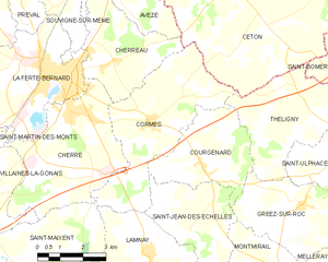
Cormes
- commune in Sarthe, France
- Country:
- Postal Code: 72400
- Coordinates: 48° 10' 12" N, 0° 42' 17" E
- GPS tracks (wikiloc): [Link]
- Area: 19 sq km
- Population: 906
- Web site: [Link]


Cherré, Sarthe
- commune in Sarthe, France
- Country:
- Postal Code: 72400
- Coordinates: 48° 10' 21" N, 0° 39' 30" E
- GPS tracks (wikiloc): [Link]
- Area: 18.73 sq km
- Population: 1731
- Web site: [Link]


Le Luart
- commune in Sarthe, France
- Country:
- Postal Code: 72390
- Coordinates: 48° 4' 11" N, 0° 35' 10" E
- GPS tracks (wikiloc): [Link]
- Area: 12.23 sq km
- Population: 1452
- Web site: [Link]


Bouër
- commune in Sarthe, France
- Country:
- Postal Code: 72390
- Coordinates: 48° 4' 55" N, 0° 37' 49" E
- GPS tracks (wikiloc): [Link]
- Area: 12 sq km
- Population: 321


Lamnay
- commune in Sarthe, France
- Country:
- Postal Code: 72320
- Coordinates: 48° 6' 58" N, 0° 42' 15" E
- GPS tracks (wikiloc): [Link]
- Area: 22.09 sq km
- Population: 962