Saint-Maur-des-Bois (Saint-Maur-des-Bois)

- commune in Manche, France
- Country:

- Postal Code: 50800
- Coordinates: 48° 49' 20" N, 1° 9' 27" E


- GPS tracks (wikiloc): [Link]
- Area: 4.97 sq km
- Population: 148
- Wikipedia en: wiki(en)
- Wikipedia: wiki(fr)
- Wikidata storage: Wikidata: Q1061838
- Wikipedia Commons Category: [Link]
- Freebase ID: [/m/02dt40]
- Freebase ID: [/m/02dt40]
- GeoNames ID: Alt: [6435624]
- GeoNames ID: Alt: [6435624]
- SIREN number: [215005216]
- SIREN number: [215005216]
- BnF ID: [152624946]
- BnF ID: [152624946]
- INSEE municipality code: 50521
- INSEE municipality code: 50521
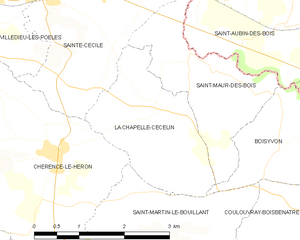
Shares border with regions:


Boisyvon
- commune in Manche, France
- Country:
- Postal Code: 50800
- Coordinates: 48° 48' 20" N, 1° 7' 44" E
- GPS tracks (wikiloc): [Link]
- Area: 3.85 sq km
- Population: 110

La Chapelle-Cécelin
- commune in Manche, France
- Country:
- Postal Code: 50800
- Coordinates: 48° 48' 39" N, 1° 9' 38" E
- GPS tracks (wikiloc): [Link]
- Area: 5.22 sq km
- Population: 238


Saint-Aubin-des-Bois
- commune in Calvados, France
- Country:
- Postal Code: 14380
- Coordinates: 48° 49' 45" N, 1° 7' 43" E
- GPS tracks (wikiloc): [Link]
- Area: 8.26 sq km
- Population: 234


Sainte-Cécile
- commune in Manche, France
- Country:
- Postal Code: 50800
- Coordinates: 48° 50' 8" N, 1° 11' 22" E
- GPS tracks (wikiloc): [Link]
- Area: 11.29 sq km
- Population: 829