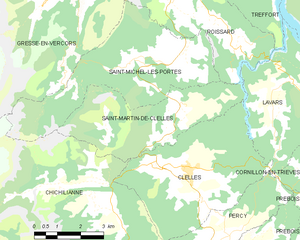
Saint-Michel-les-Portes (Saint-Michel-les-Portes)

- commune in Isère, France
 Hiking in Saint-Michel-les-Portes
Saint-Michel-les-Portes is a charming village located in the French Alps, offering beautiful landscapes and numerous hiking opportunities. The region is known for its picturesque scenery, with rolling hills, forests, and clear streams, making it an ideal spot for both novice and experienced hikers.
Hiking Trails
-
Local Trails: There are several marked trails starting from the village, ranging from easy walks to more challenging hikes. These trails typically lead through scenic forests and provide stunning views of the surrounding mountains.
-
The GR de Pays Trail: This long-distance trail, known as a Grande Randonnée (GR), often passes through the area and offers a more extended hiking experience. Hikers can enjoy diverse landscapes and the chance to explore nearby villages.
-
Mount Cheval Blanc: For those seeking a challenge, a hike up to Mount Cheval Blanc provides incredible panoramic views of the Alps. The terrain can be rocky and steep, so proper preparation is essential.
Season Considerations
- Spring and Summer: Ideal for hiking, as the weather is usually mild, and the trails are accessible. This is also when wildflowers bloom, enhancing the beauty of the area.
- Autumn: Offers breathtaking fall colors, but be prepared for cooler temperatures.
- Winter: Hiking is more challenging due to snow, but there are opportunities for snowshoeing and winter hiking for those equipped for it.
Tips for Hiking in Saint-Michel-les-Portes
- Maps and Guides: Always carry a detailed map or a guidebook to navigate the trails safely.
- Weather Check: The weather can change rapidly in the mountains, so checking the forecast before heading out is crucial.
- Equipment: Wear suitable hiking boots and clothing, and carry water, snacks, and a first-aid kit for longer hikes.
- Respect Nature: Follow the Leave No Trace principles to help preserve the natural beauty of the area.
Local Attractions
Besides hiking, visitors can also explore the village's historical sites, local cuisine, and cultural experiences. Engaging with the local community can enhance your experience further.
In summary, hiking in Saint-Michel-les-Portes is a rewarding experience, ideal for anyone looking to enjoy the beauty of the French Alps in a peaceful, natural setting. Always plan ahead to ensure a safe and enjoyable adventure!
- Country:

- Postal Code: 38650
- Coordinates: 44° 52' 8" N, 5° 35' 40" E


- GPS tracks (wikiloc): [Link]
- Area: 20.59 sq km
- Population: 268
- Wikipedia en: wiki(en)
- Wikipedia: wiki(fr)
- Wikidata storage: Wikidata: Q1150674
- Wikipedia Commons Category: [Link]
- Freebase ID: [/m/03g_5v0]
- GeoNames ID: Alt: [6433375]
- SIREN number: [213804297]
- BnF ID: [15258238d]
- INSEE municipality code: 38429
Shares border with regions:

Saint-Martin-de-Clelles
- commune in Isère, France
Hiking in Saint-Martin-de-Clelles
Saint-Martin-de-Clelles is a small village located in the picturesque region of the French Alps, specifically in the department of Isère. This area is known for its stunning natural beauty, making it a great destination for hiking enthusiasts. Here are some highlights and tips about hiking in and around Saint-Martin-de-Clelles:...
- Country:
- Postal Code: 38930
- Coordinates: 44° 50' 44" N, 5° 37' 18" E
- GPS tracks (wikiloc): [Link]
- Area: 14.72 sq km
- Population: 181
- Web site: [Link]


Gresse-en-Vercors
- commune in Isère, France
Hiking in Gresse-en-Vercors
Gresse-en-Vercors is a charming village located in the Vercors Regional Natural Park in the French Alps. It’s an exceptional area for hiking, offering a variety of trails that cater to a range of skill levels, from beginners to experienced hikers. Here are some highlights and things to consider when hiking in Gresse-en-Vercors:...
- Country:
- Postal Code: 38650
- Coordinates: 44° 54' 8" N, 5° 34' 0" E
- GPS tracks (wikiloc): [Link]
- Area: 81.13 sq km
- Population: 395
- Web site: [Link]


Roissard
- commune in Isère, France
Hiking in Roissard
Roissard is a charming village located in the French Alps, specifically in the Isère department, offering stunning natural beauty and a variety of hiking opportunities for outdoor enthusiasts. Here are some key points to consider if you’re looking to hike in and around Roissard:...
- Country:
- Postal Code: 38650
- Coordinates: 44° 52' 56" N, 5° 38' 23" E
- GPS tracks (wikiloc): [Link]
- Area: 14.25 sq km
- Population: 298
- Web site: [Link]


Chichilianne
- commune in Isère, France
Hiking in Chichilianne
Chichilianne is a charming village located in the Vercors Regional Natural Park in southeastern France, often referred to as the "Gateway to the Vercors." The area is known for its stunning natural landscapes, including rugged mountains, deep valleys, and diverse flora and fauna, making it an excellent destination for hiking enthusiasts....
- Country:
- Postal Code: 38930
- Coordinates: 44° 48' 42" N, 5° 34' 20" E
- GPS tracks (wikiloc): [Link]
- Area: 62.48 sq km
- Population: 284
- Web site: [Link]