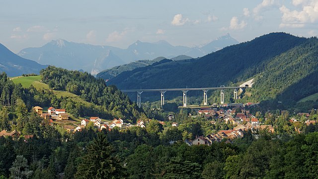
Roissard (Roissard)

- commune in Isère, France
 Hiking in Roissard
Roissard is a charming village located in the French Alps, specifically in the Isère department, offering stunning natural beauty and a variety of hiking opportunities for outdoor enthusiasts. Here are some key points to consider if you’re looking to hike in and around Roissard:
Hiking Trails
-
Scenic Routes: The area is known for its picturesque landscapes, including lush forests, alpine meadows, and panoramic views of the surrounding mountains. Popular trails often lead to vantage points where hikers can enjoy stunning vistas.
-
Difficulty Levels: There are trails suitable for all levels of hikers, from beginners to advanced. Ensure you choose a trail that matches your fitness level and experience.
-
Local Recommendations: Consider checking with local tourism offices or guides for trail maps, updated conditions, and recommendations based on seasonal changes.
Points of Interest
- Nature Reserves: The nearby nature reserves offer opportunities for wildlife spotting, including various bird species and other fauna indigenous to the region.
- Historical Sites: Some hiking trails may take you past historical or cultural sites, enriching your experience and understanding of the region.
Best Time to Hike
- Spring and Fall: These seasons generally offer mild weather and fewer crowds. Wildflowers in spring and autumn foliage in fall provide breathtaking scenery.
- Summer: While the trails can be busier, summer is an excellent time for hiking due to the extended daylight hours and vibrant nature.
Safety and Preparedness
- Weather Considerations: Always check the weather forecast before heading out, as conditions can change rapidly in the mountains.
- Gear: Proper hiking footwear, clothing, and gear are essential. Bring plenty of water, snacks, and a map or GPS device.
- Stay Aware: Follow trail markers and signs carefully, and if you're unfamiliar with the area, consider hiking with a guide.
Conclusion
Exploring Roissard through its hiking trails can be a rewarding experience filled with adventure and natural beauty. Take your time to savor the landscape and enjoy the outdoors responsibly!
- Country:

- Postal Code: 38650
- Coordinates: 44° 52' 56" N, 5° 38' 23" E


- GPS tracks (wikiloc): [Link]
- Area: 14.25 sq km
- Population: 298
- Web site: http://www.mairieroissard.fr
- Wikipedia en: wiki(en)
- Wikipedia: wiki(fr)
- Wikidata storage: Wikidata: Q339144
- Wikipedia Commons Category: [Link]
- Freebase ID: [/m/03nvjnm]
- GeoNames ID: Alt: [6433307]
- SIREN number: [213803422]
- BnF ID: [152581531]
- INSEE municipality code: 38342
Shares border with regions:

Monestier-de-Clermont
- commune in Isère, France
Hiking in Monestier-de-Clermont
Monestier-de-Clermont, located in the picturesque Isère department in the Auvergne-Rhône-Alpes region of France, offers a variety of hiking opportunities that showcase the stunning natural beauty of the French Alps. Here are some highlights and tips for hiking in this area:...
- Country:
- Postal Code: 38650
- Coordinates: 44° 55' 1" N, 5° 38' 7" E
- GPS tracks (wikiloc): [Link]
- Area: 5.45 sq km
- Population: 1426
- Web site: [Link]

Saint-Paul-lès-Monestier
- commune in Isère, France
Hiking in Saint-Paul-lès-Monestier
Saint-Paul-lès-Monestier is a picturesque village located in the Isère department in the Auvergne-Rhône-Alpes region of southeastern France. It serves as an excellent base for hiking enthusiasts who want to explore the beautiful landscapes of the Vercors Massif....
- Country:
- Postal Code: 38650
- Coordinates: 44° 55' 46" N, 5° 37' 40" E
- GPS tracks (wikiloc): [Link]
- Area: 13.88 sq km
- Population: 257


Saint-Michel-les-Portes
- commune in Isère, France
Hiking in Saint-Michel-les-Portes
Saint-Michel-les-Portes is a charming village located in the French Alps, offering beautiful landscapes and numerous hiking opportunities. The region is known for its picturesque scenery, with rolling hills, forests, and clear streams, making it an ideal spot for both novice and experienced hikers....
- Country:
- Postal Code: 38650
- Coordinates: 44° 52' 8" N, 5° 35' 40" E
- GPS tracks (wikiloc): [Link]
- Area: 20.59 sq km
- Population: 268

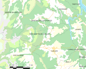
Saint-Martin-de-Clelles
- commune in Isère, France
Hiking in Saint-Martin-de-Clelles
Saint-Martin-de-Clelles is a small village located in the picturesque region of the French Alps, specifically in the department of Isère. This area is known for its stunning natural beauty, making it a great destination for hiking enthusiasts. Here are some highlights and tips about hiking in and around Saint-Martin-de-Clelles:...
- Country:
- Postal Code: 38930
- Coordinates: 44° 50' 44" N, 5° 37' 18" E
- GPS tracks (wikiloc): [Link]
- Area: 14.72 sq km
- Population: 181
- Web site: [Link]

Treffort
- commune in Isère, France
Hiking in Treffort
Treffort is a charming village located in the Auvergne-Rhône-Alpes region of southeastern France. It is surrounded by picturesque landscapes that offer a variety of hiking opportunities. Here’s what you can expect when hiking in and around Treffort:...
- Country:
- Postal Code: 38650
- Coordinates: 44° 54' 56" N, 5° 39' 29" E
- GPS tracks (wikiloc): [Link]
- AboveSeaLevel: 618 м m
- Area: 10.99 sq km
- Population: 276


Gresse-en-Vercors
- commune in Isère, France
Hiking in Gresse-en-Vercors
Gresse-en-Vercors is a charming village located in the Vercors Regional Natural Park in the French Alps. It’s an exceptional area for hiking, offering a variety of trails that cater to a range of skill levels, from beginners to experienced hikers. Here are some highlights and things to consider when hiking in Gresse-en-Vercors:...
- Country:
- Postal Code: 38650
- Coordinates: 44° 54' 8" N, 5° 34' 0" E
- GPS tracks (wikiloc): [Link]
- Area: 81.13 sq km
- Population: 395
- Web site: [Link]


Lavars
- commune in Isère, France
Hiking in Lavars
Lavars is a small village located in the Auvergne-Rhône-Alpes region of France, known for its beautiful natural surroundings and potential hiking opportunities. While Lavars itself may not have extensive trails, it serves as a good base for exploring the surrounding areas, particularly the Vercors Regional Natural Park and the Chartreuse Mountains which are within a reasonable distance....
- Country:
- Postal Code: 38710
- Coordinates: 44° 50' 56" N, 5° 40' 21" E
- GPS tracks (wikiloc): [Link]
- Area: 14.8 sq km
- Population: 149