Saint-Ouen-le-Pin (Saint-Ouen-le-Pin)

- commune in Calvados, France
- Country:

- Postal Code: 14340
- Coordinates: 49° 8' 53" N, 0° 6' 24" E


- GPS tracks (wikiloc): [Link]
- Area: 5.59 sq km
- Population: 264
- Wikipedia en: wiki(en)
- Wikipedia: wiki(fr)
- Wikidata storage: Wikidata: Q746852
- Wikipedia Commons Category: [Link]
- Freebase ID: [/m/03yhdb]
- GeoNames ID: Alt: [2977796]
- SIREN number: [211406392]
- BnF ID: [15248047m]
- VIAF ID: Alt: [137677279]
- Library of Congress authority ID: Alt: [nr2006022529]
- INSEE municipality code: 14639
Shares border with regions:


Cambremer
- commune in Calvados, France
- Country:
- Postal Code: 14340
- Coordinates: 49° 9' 7" N, 0° 2' 52" E
- GPS tracks (wikiloc): [Link]
- Area: 23.57 sq km
- Population: 1166
- Web site: [Link]


Manerbe
- commune in Calvados, France
- Country:
- Postal Code: 14340
- Coordinates: 49° 11' 6" N, 0° 10' 28" E
- GPS tracks (wikiloc): [Link]
- Area: 18.27 sq km
- Population: 556


La Houblonnière
- commune in Calvados, France
- Country:
- Postal Code: 14340
- Coordinates: 49° 7' 29" N, 0° 6' 17" E
- GPS tracks (wikiloc): [Link]
- Area: 7.1 sq km
- Population: 327


Montreuil-en-Auge
- commune in Calvados, France
- Country:
- Postal Code: 14340
- Coordinates: 49° 10' 17" N, 0° 3' 17" E
- GPS tracks (wikiloc): [Link]
- Area: 3.37 sq km
- Population: 52

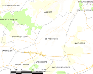
Le Pré-d'Auge
- commune in Calvados, France
- Country:
- Postal Code: 14340
- Coordinates: 49° 9' 7" N, 0° 8' 8" E
- GPS tracks (wikiloc): [Link]
- Area: 10.72 sq km
- Population: 892