Saint-Pey-de-Castets (Saint-Pey-de-Castets)

- commune in Gironde, France
- Country:

- Postal Code: 33350
- Coordinates: 44° 48' 39" N, 0° 4' 6" E


- GPS tracks (wikiloc): [Link]
- Area: 11.07 sq km
- Population: 627
- Wikipedia en: wiki(en)
- Wikipedia: wiki(fr)
- Wikidata storage: Wikidata: Q185475
- Wikipedia Commons Category: [Link]
- Freebase ID: [/m/03ns1wl]
- GeoNames ID: Alt: [6432436]
- SIREN number: [213304603]
- BnF ID: [15256508t]
- PACTOLS thesaurus ID: [pcrtSRp5fQt9ZX]
- INSEE municipality code: 33460
Shares border with regions:

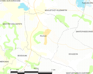
Pujols
- commune in Gironde, France
- Country:
- Postal Code: 33350
- Coordinates: 44° 48' 24" N, 0° 1' 52" E
- GPS tracks (wikiloc): [Link]
- Area: 7.4 sq km
- Population: 561
- Web site: [Link]


Sainte-Florence
- commune in Gironde, France
- Country:
- Postal Code: 33350
- Coordinates: 44° 48' 46" N, 0° 5' 29" E
- GPS tracks (wikiloc): [Link]
- Area: 3.21 sq km
- Population: 147

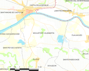
Mouliets-et-Villemartin
- commune in Gironde, France
- Country:
- Postal Code: 33350
- Coordinates: 44° 50' 31" N, 0° 1' 7" E
- GPS tracks (wikiloc): [Link]
- Area: 15.91 sq km
- Population: 1072


Saint-Magne-de-Castillon
- commune in Gironde, France
- Country:
- Postal Code: 33350
- Coordinates: 44° 51' 51" N, 0° 3' 54" E
- GPS tracks (wikiloc): [Link]
- Area: 13.87 sq km
- Population: 2003


Bossugan
- commune in Gironde, France
- Country:
- Postal Code: 33350
- Coordinates: 44° 47' 30" N, 0° 2' 44" E
- GPS tracks (wikiloc): [Link]
- Area: 2.42 sq km
- Population: 47


Civrac-sur-Dordogne
- commune in Gironde, France
- Country:
- Postal Code: 33350
- Coordinates: 44° 49' 47" N, 0° 4' 53" E
- GPS tracks (wikiloc): [Link]
- AboveSeaLevel: 6 м m
- Area: 1.94 sq km
- Population: 212


Mérignas
- commune in Gironde, France
- Country:
- Postal Code: 33350
- Coordinates: 44° 47' 4" N, 0° 5' 16" E
- GPS tracks (wikiloc): [Link]
- Area: 9.56 sq km
- Population: 325