Saint-Pierre-la-Cour (Saint-Pierre-la-Cour)

- commune in Mayenne, France
- Country:

- Postal Code: 53410
- Coordinates: 48° 6' 54" N, 1° 1' 35" E


- GPS tracks (wikiloc): [Link]
- Area: 15.69 sq km
- Population: 2136
- Web site: http://www.saintpierrelacour.fr
- Wikipedia en: wiki(en)
- Wikipedia: wiki(fr)
- Wikidata storage: Wikidata: Q544967
- Wikipedia Commons Category: [Link]
- Freebase ID: [/m/03nq0lz]
- GeoNames ID: Alt: [2977446]
- SIREN number: [215302472]
- BnF ID: [15264040n]
- INSEE municipality code: 53247
Shares border with regions:


Bréal-sous-Vitré
- commune in Ille-et-Vilaine, France
- Country:
- Postal Code: 35370
- Coordinates: 48° 6' 11" N, 1° 3' 40" E
- GPS tracks (wikiloc): [Link]
- Area: 5.75 sq km
- Population: 655

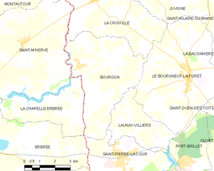
Bourgon
- commune in Mayenne, France
- Country:
- Postal Code: 53410
- Coordinates: 48° 10' 2" N, 1° 4' 0" E
- GPS tracks (wikiloc): [Link]
- Area: 20.97 sq km
- Population: 655


Launay-Villiers
- commune in Mayenne, France
- Country:
- Postal Code: 53410
- Coordinates: 48° 8' 3" N, 1° 0' 32" E
- GPS tracks (wikiloc): [Link]
- Area: 9.05 sq km
- Population: 391

Erbrée
- commune in Ille-et-Vilaine, France
- Country:
- Postal Code: 35500
- Coordinates: 48° 5' 56" N, 1° 7' 28" E
- GPS tracks (wikiloc): [Link]
- Area: 35.52 sq km
- Population: 1677
- Web site: [Link]


La Gravelle
- commune in Mayenne, France
- Country:
- Postal Code: 53410
- Coordinates: 48° 4' 22" N, 1° 0' 57" E
- GPS tracks (wikiloc): [Link]
- Area: 6.23 sq km
- Population: 519


La Brûlatte
- commune in Mayenne, France
- Country:
- Postal Code: 53410
- Coordinates: 48° 5' 7" N, 0° 57' 12" E
- GPS tracks (wikiloc): [Link]
- Area: 15.24 sq km
- Population: 701
- Web site: [Link]


Port-Brillet
- commune in Mayenne, France
- Country:
- Postal Code: 53410
- Coordinates: 48° 6' 47" N, 0° 58' 15" E
- GPS tracks (wikiloc): [Link]
- Area: 8.1 sq km
- Population: 1833
- Web site: [Link]