Saint-Projet-Saint-Constant (Saint-Projet-Saint-Constant)

- commune in Charente, France
- Country:

- Postal Code: 16110
- Coordinates: 45° 44' 19" N, 0° 21' 38" E


- GPS tracks (wikiloc): [Link]
- Area: 16.94 sq km
- Population: 1072
- Web site: http://st-projet-st-constant.fr
- Wikipedia en: wiki(en)
- Wikipedia: wiki(fr)
- Wikidata storage: Wikidata: Q961542
- Wikipedia Commons Category: [Link]
- Freebase ID: [/m/03mcdlv]
- GeoNames ID: Alt: [2977310]
- SIREN number: [211603444]
- BnF ID: [15248781q]
- PACTOLS thesaurus ID: [pcrtY44osGUVqM]
- INSEE municipality code: 16344
Shares border with regions:

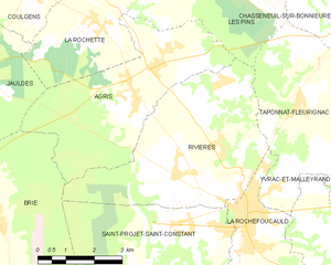
Rivières
- commune in Charente, France
- Country:
- Postal Code: 16110
- Coordinates: 45° 45' 10" N, 0° 21' 43" E
- GPS tracks (wikiloc): [Link]
- Area: 21.54 sq km
- Population: 1985

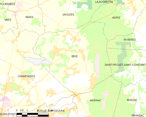
Brie
- commune in Charente, France
- Country:
- Postal Code: 16590
- Coordinates: 45° 44' 16" N, 0° 14' 27" E
- GPS tracks (wikiloc): [Link]
- AboveSeaLevel: 135 м m
- Area: 34.05 sq km
- Population: 4260

Rancogne
- commune in Charente, France
- Country:
- Postal Code: 16110
- Coordinates: 45° 41' 48" N, 0° 24' 13" E
- GPS tracks (wikiloc): [Link]
- Area: 12.52 sq km
- Population: 379


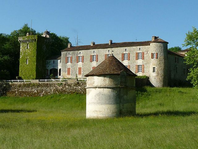
La Rochefoucauld
- commune in Charente, France
- Country:
- Postal Code: 16110
- Coordinates: 45° 44' 26" N, 0° 23' 10" E
- GPS tracks (wikiloc): [Link]
- Area: 7.21 sq km
- Population: 2954
- Web site: [Link]


Bunzac
- commune in Charente, France
- Country:
- Postal Code: 16110
- Coordinates: 45° 42' 4" N, 0° 21' 5" E
- GPS tracks (wikiloc): [Link]
- Area: 13.32 sq km
- Population: 467


Mornac
- commune in Charente, France
- Country:
- Postal Code: 16600
- Coordinates: 45° 40' 50" N, 0° 16' 19" E
- GPS tracks (wikiloc): [Link]
- Area: 23.48 sq km
- Population: 2184
- Web site: [Link]