Saint-Rémy-de-Maurienne (Saint-Rémy-de-Maurienne)

- commune in Savoie, France
 Hiking in Saint-Rémy-de-Maurienne
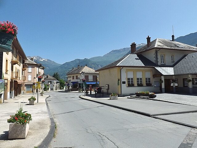
Saint-Rémy-de-Maurienne is a charming village located in the Savoie region of the French Alps, offering excellent opportunities for hiking enthusiasts. Nestled in the Maurienne Valley, the area is surrounded by stunning alpine scenery, making it an excellent base for outdoor activities.
Hiking Trails
-
Sentier des Crêts: A relatively easy hike that offers breathtaking views of the Maurienne Valley and the surrounding peaks. This trail is suitable for families and provides some lovely picnic spots along the way.
-
Col du Glandon: For those looking for more challenging hikes, the trail to Col du Glandon will provide both physical challenges and spectacular mountain views. The ascent can be steep, but the vistas at the top are worth the effort.
-
Les Chalets de la Balme: This hike takes you to picturesque old wooden chalets, providing insight into local heritage along with beautiful panoramic views of the surrounding mountains.
Best Time to Hike
The prime hiking season in Saint-Rémy-de-Maurienne generally runs from late spring through early autumn (May to September). The weather is typically mild, and trails are more accessible without snow.
Tips for Hiking
- Gear Up: Make sure you have proper hiking boots, weather-appropriate clothing, and plenty of water.
- Maps and Guides: Consider obtaining a local hiking map or hiring a guide, especially if you’re unfamiliar with the area.
- Respect Nature: Follow the Leave No Trace principles to preserve the beauty of the landscape.
- Safety First: Keep an eye on weather conditions and be aware of your surroundings, as mountain weather can change rapidly.
Additional Activities
Besides hiking, Saint-Rémy-de-Maurienne offers opportunities for mountain biking, paragliding, and skiing in winter, making it a year-round destination for outdoor enthusiasts.
If you’re looking for a beautiful place to hike in the French Alps, Saint-Rémy-de-Maurienne offers a delightful blend of natural beauty, well-maintained trails, and the charm of a small mountain village. Enjoy your adventure!
- Country:

- Postal Code: 73660
- Coordinates: 45° 23' 31" N, 6° 15' 54" E


- GPS tracks (wikiloc): [Link]
- Area: 44.26 sq km
- Population: 1282
- Web site: http://www.saintremydemaurienne.com/
- Wikipedia en: wiki(en)
- Wikipedia: wiki(fr)
- Wikidata storage: Wikidata: Q601361
- Wikipedia Commons Category: [Link]
- Freebase ID: [/m/03npfsx]
- GeoNames ID: Alt: [6617592]
- SIREN number: [217302785]
- BnF ID: [152742098]
- VIAF ID: Alt: [247834171]
- INSEE municipality code: 73278
Shares border with regions:
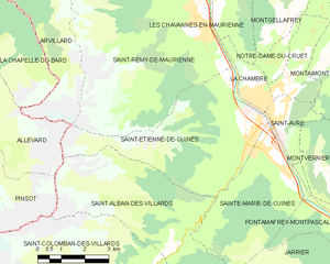
Saint-Étienne-de-Cuines
- commune in Savoie, France
Hiking in Saint-Étienne-de-Cuines
Saint-Étienne-de-Cuines, located in the Savoie region of the French Alps, offers beautiful hiking opportunities amidst stunning mountain scenery. The area is characterized by picturesque landscapes, including forests, alpine meadows, and views of the surrounding peaks....
- Country:
- Postal Code: 73130
- Coordinates: 45° 20' 32" N, 6° 17' 30" E
- GPS tracks (wikiloc): [Link]
- Area: 20.5 sq km
- Population: 1190


Les Chavannes-en-Maurienne
- commune in Savoie, France
Hiking in Les Chavannes-en-Maurienne
Les Chavannes-en-Maurienne is a delightful destination for hiking enthusiasts, nestled in the Maurienne Valley in the French Alps. This picturesque village offers a range of hiking opportunities, catering to all skill levels. Here are some highlights:...
- Country:
- Postal Code: 73660
- Coordinates: 45° 23' 29" N, 6° 16' 55" E
- GPS tracks (wikiloc): [Link]
- Area: 4.69 sq km
- Population: 255
Presle
- commune in Savoie, France
Hiking in Presle
Presle, located in the Auvergne-Rhône-Alpes region of France, is a beautiful area known for its stunning landscapes and diverse hiking opportunities. Nestled near the Vercors Mountains, it offers a range of trails suitable for hikers of all skill levels, from leisurely walks to more challenging treks....
- Country:
- Postal Code: 73110
- Coordinates: 45° 27' 16" N, 6° 8' 18" E
- GPS tracks (wikiloc): [Link]
- Area: 11.58 sq km
- Population: 419
Saint-Pierre-de-Belleville
- commune in Savoie, France
Hiking in Saint-Pierre-de-Belleville
Saint-Pierre-de-Belleville is a charming village located in the Savoie region of the French Alps. It offers a variety of hiking opportunities, catering to different skill levels and preferences. Here are some highlights of hiking in this area:...
- Country:
- Postal Code: 73220
- Coordinates: 45° 28' 15" N, 6° 16' 54" E
- GPS tracks (wikiloc): [Link]
- Area: 7.46 sq km
- Population: 172
La Chapelle, Savoie
- commune in Savoie, France
Hiking in La Chapelle, Savoie
La Chapelle, located in the Savoie region of the French Alps, is a picturesque village that serves as a great base for hiking enthusiasts. The area is known for its stunning alpine scenery, offering a variety of trails suitable for all levels of hikers, from beginners to experienced trekkers....
- Country:
- Postal Code: 73660
- Coordinates: 45° 25' 8" N, 6° 16' 41" E
- GPS tracks (wikiloc): [Link]
- Area: 12.28 sq km
- Population: 339

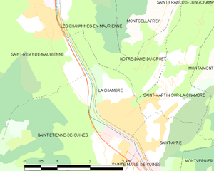
La Chambre
- commune in Savoie, France
Hiking in La Chambre
La Chambre is a charming village located in the Savoie region of the French Alps. It’s a great launching point for a variety of hiking trails that cater to different skill levels, from easy walks to more challenging treks. Here are some important aspects of hiking in La Chambre:...
- Country:
- Postal Code: 73130
- Coordinates: 45° 21' 34" N, 6° 18' 0" E
- GPS tracks (wikiloc): [Link]
- Area: 3.2 sq km
- Population: 1148
- Web site: [Link]


Arvillard
- commune in Savoie, France
Hiking in Arvillard
Arvillard is a charming commune located in the Savoie department of the Auvergne-Rhône-Alpes region in southeastern France. It is well-known for its stunning natural scenery and offers a variety of hikes that cater to different skill levels....
- Country:
- Postal Code: 73110
- Coordinates: 45° 26' 29" N, 6° 7' 12" E
- GPS tracks (wikiloc): [Link]
- Area: 29.28 sq km
- Population: 846
- Web site: [Link]


Saint-Léger, Savoie
- commune in Savoie, France
Hiking in Saint-Léger, Savoie
Saint-Léger, located in the Savoie region of the French Alps, offers stunning scenery and a variety of hiking opportunities for outdoor enthusiasts. The area is known for its picturesque landscapes, including mountains, forests, and alpine meadows, making it an ideal destination for hikers of all skill levels....
- Country:
- Postal Code: 73220
- Coordinates: 45° 26' 10" N, 6° 16' 35" E
- GPS tracks (wikiloc): [Link]
- Area: 11.06 sq km
- Population: 231