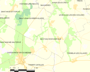
Saint-Sauveur-Marville (Saint-Sauveur-Marville)
- commune in Eure-et-Loir, France
- Country:

- Postal Code: 28170
- Coordinates: 48° 35' 43" N, 1° 16' 45" E


- GPS tracks (wikiloc): [Link]
- AboveSeaLevel: 187 м m
- Area: 18.84 sq km
- Population: 920
- Web site: http://www.saintsauveurmarville.fr
- Wikipedia en: wiki(en)
- Wikipedia: wiki(fr)
- Wikidata storage: Wikidata: Q955765
- Wikipedia Commons Category: [Link]
- Freebase ID: [/m/03nrmrg]
- GeoNames ID: Alt: [6616336]
- SIREN number: [212803605]
- BnF ID: [15254290j]
- VIAF ID: Alt: [305352759]
- INSEE municipality code: 28360
Shares border with regions:


Thimert-Gâtelles
- commune in Eure-et-Loir, France
- Country:

- Postal Code: 28170
- Coordinates: 48° 34' 10" N, 1° 15' 5" E


- GPS tracks (wikiloc): [Link]
- AboveSeaLevel: 200 м m
- Area: 42.67 sq km
- Population: 1278
- Web site: [Link]


Tremblay-les-Villages
- commune in Eure-et-Loir, France
- Country:

- Postal Code: 28170
- Coordinates: 48° 36' 3" N, 1° 22' 52" E


- GPS tracks (wikiloc): [Link]
- AboveSeaLevel: 198 м m
- Area: 63.31 sq km
- Population: 2287
- Web site: [Link]
