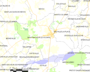
Saint-Sauveur-le-Vicomte (Saint-Sauveur-le-Vicomte)
- commune in Manche, France
- Country:

- Postal Code: 50390
- Coordinates: 49° 23' 12" N, 1° 31' 56" E


- GPS tracks (wikiloc): [Link]
- Area: 34.27 sq km
- Population: 2199
- Web site: http://www.ville-saint-sauveur-le-vicomte.fr
- Wikipedia en: wiki(en)
- Wikipedia: wiki(fr)
- Wikidata storage: Wikidata: Q668199
- Wikipedia Commons Gallery: [Link]
- Wikipedia Commons Category: [Link]
- Freebase ID: [/m/02sgtv]
- Freebase ID: [/m/02sgtv]
- GeoNames ID: Alt: [2977007]
- GeoNames ID: Alt: [2977007]
- SIREN number: [215005513]
- SIREN number: [215005513]
- BnF ID: [15262522m]
- BnF ID: [15262522m]
- VIAF ID: Alt: [130292679]
- VIAF ID: Alt: [130292679]
- Library of Congress authority ID: Alt: [n88165487]
- Library of Congress authority ID: Alt: [n88165487]
- PACTOLS thesaurus ID: [pcrtiSA75Oxunj]
- PACTOLS thesaurus ID: [pcrtiSA75Oxunj]
- INSEE municipality code: 50551
- INSEE municipality code: 50551
Shares border with regions:


Doville
- commune in Manche, France
- Country:

- Postal Code: 50250
- Coordinates: 49° 19' 54" N, 1° 32' 25" E


- GPS tracks (wikiloc): [Link]
- Area: 11.09 sq km
- Population: 317


Catteville
- commune in Manche, France
- Country:

- Postal Code: 50390
- Coordinates: 49° 21' 21" N, 1° 34' 11" E


- GPS tracks (wikiloc): [Link]
- Area: 4.57 sq km
- Population: 106


Saint-Jacques-de-Néhou
- commune in Manche, France
- Country:

- Postal Code: 50390
- Coordinates: 49° 25' 5" N, 1° 36' 47" E


- GPS tracks (wikiloc): [Link]
- Area: 21.49 sq km
- Population: 592


Sainte-Colombe
- commune in Manche, France
- Country:

- Postal Code: 50390
- Coordinates: 49° 25' 18" N, 1° 31' 20" E


- GPS tracks (wikiloc): [Link]
- Area: 4.99 sq km
- Population: 215


Rauville-la-Place
- commune in Manche, France
- Country:

- Postal Code: 50390
- Coordinates: 49° 23' 18" N, 1° 30' 17" E


- GPS tracks (wikiloc): [Link]
- Area: 11.88 sq km
- Population: 386


Néhou
- commune in Manche, France
- Country:

- Postal Code: 50390
- Coordinates: 49° 25' 12" N, 1° 32' 31" E


- GPS tracks (wikiloc): [Link]
- Area: 15.98 sq km
- Population: 611


Besneville
- commune in Manche, France
- Country:

- Postal Code: 50390
- Coordinates: 49° 22' 4" N, 1° 37' 39" E


- GPS tracks (wikiloc): [Link]
- Area: 18.27 sq km
- Population: 667


Varenguebec
- commune in Manche, France
- Country:

- Postal Code: 50250
- Coordinates: 49° 20' 19" N, 1° 29' 53" E


- GPS tracks (wikiloc): [Link]
- Area: 21.19 sq km
- Population: 318


Taillepied
- commune in Manche, France
- Country:

- Postal Code: 50390
- Coordinates: 49° 22' 21" N, 1° 34' 56" E


- GPS tracks (wikiloc): [Link]
- AboveSeaLevel: 16 м m
- Area: 2.15 sq km
- Population: 26
