Saint-Symphorien-des-Monts (Saint-Symphorien-des-Monts)

- former commune in Manche, France
- Country:

- Postal Code: 50640
- Coordinates: 48° 32' 37" N, 1° 0' 10" E


- GPS tracks (wikiloc): [Link]
- Area: 6.81 sq km
- Population: 149
- Wikipedia en: wiki(en)
- Wikipedia: wiki(fr)
- Wikidata storage: Wikidata: Q627245
- Wikipedia Commons Category: [Link]
- Freebase ID: [/m/03x_z9m]
- GeoNames ID: Alt: [6435652]
- BnF ID: [15262528p]
- INSEE municipality code: 50557
Shares border with regions:

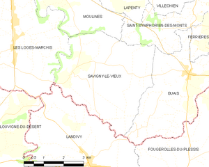
Savigny-le-Vieux
- commune in Manche, France
- Country:
- Postal Code: 50640
- Coordinates: 48° 31' 15" N, 1° 2' 53" E
- GPS tracks (wikiloc): [Link]
- Area: 17.16 sq km
- Population: 443


Lapenty
- commune in Manche, France
- Country:
- Postal Code: 50600
- Coordinates: 48° 34' 45" N, 1° 0' 25" E
- GPS tracks (wikiloc): [Link]
- Area: 14.89 sq km
- Population: 387
- Web site: [Link]


Ferrières
- former commune in Manche, France
- Country:
- Postal Code: 50640
- Coordinates: 48° 32' 38" N, 0° 57' 27" E
- GPS tracks (wikiloc): [Link]
- AboveSeaLevel: 129 м m
- Area: 3.51 sq km
- Population: 53

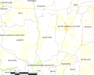
Villechien
- former commune in Manche, France
- Country:
- Postal Code: 50140
- Coordinates: 48° 34' 46" N, 0° 59' 11" E
- GPS tracks (wikiloc): [Link]
- Area: 10.83 sq km
- Population: 177


Notre-Dame-du-Touchet
- former commune in Manche, France
- Country:
- Postal Code: 50140
- Coordinates: 48° 34' 57" N, 0° 57' 24" E
- GPS tracks (wikiloc): [Link]
- Area: 17.65 sq km
- Population: 633


Moulines
- commune in Manche, France
- Country:
- Postal Code: 50600
- Coordinates: 48° 32' 43" N, 1° 1' 57" E
- GPS tracks (wikiloc): [Link]
- Area: 7.41 sq km
- Population: 296