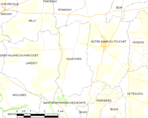
Notre-Dame-du-Touchet (Notre-Dame-du-Touchet)
- former commune in Manche, France
- Country:

- Postal Code: 50140
- Coordinates: 48° 34' 57" N, 0° 57' 24" E


- GPS tracks (wikiloc): [Link]
- Area: 17.65 sq km
- Population: 633
- Wikipedia en: wiki(en)
- Wikipedia: wiki(fr)
- Wikidata storage: Wikidata: Q530999
- Wikipedia Commons Category: [Link]
- Freebase ID: [/m/03nx9_z]
- Freebase ID: [/m/03nx9_z]
- GeoNames ID: Alt: [6435520]
- GeoNames ID: Alt: [6435520]
- BnF ID: [152623551]
- BnF ID: [152623551]
- INSEE municipality code: 50381
- INSEE municipality code: 50381
Shares border with regions:


Saint-Jean-du-Corail
- former commune in Manche, France
- Country:

- Postal Code: 50140
- Coordinates: 48° 36' 33" N, 0° 54' 33" E


- GPS tracks (wikiloc): [Link]
- Area: 14.04 sq km
- Population: 243


Husson
- former commune in Manche, France
- Country:

- Postal Code: 50640
- Coordinates: 48° 34' 12" N, 0° 53' 33" E


- GPS tracks (wikiloc): [Link]
- Area: 13.59 sq km
- Population: 182


Ferrières
- former commune in Manche, France
- Country:

- Postal Code: 50640
- Coordinates: 48° 32' 38" N, 0° 57' 27" E


- GPS tracks (wikiloc): [Link]
- AboveSeaLevel: 129 м m
- Area: 3.51 sq km
- Population: 53


Bion
- former commune in Manche, France
- Country:

- Postal Code: 50140
- Coordinates: 48° 37' 11" N, 0° 55' 9" E


- GPS tracks (wikiloc): [Link]
- Area: 12.67 sq km
- Population: 378


Villechien
- former commune in Manche, France
- Country:

- Postal Code: 50140
- Coordinates: 48° 34' 46" N, 0° 59' 11" E


- GPS tracks (wikiloc): [Link]
- Area: 10.83 sq km
- Population: 177


Saint-Symphorien-des-Monts
- former commune in Manche, France
- Country:

- Postal Code: 50640
- Coordinates: 48° 32' 37" N, 1° 0' 10" E


- GPS tracks (wikiloc): [Link]
- Area: 6.81 sq km
- Population: 149


Le Teilleul
- commune in Manche, France
- Country:

- Postal Code: 50640
- Coordinates: 48° 32' 18" N, 0° 52' 24" E


- GPS tracks (wikiloc): [Link]
- Area: 30.45 sq km
- Population: 1220
