Saint-Thierry (Saint-Thierry)

- commune in Marne, France
- Country:

- Postal Code: 51220
- Coordinates: 49° 18' 13" N, 3° 57' 49" E


- GPS tracks (wikiloc): [Link]
- Area: 7.59 sq km
- Population: 645
- Wikipedia en: wiki(en)
- Wikipedia: wiki(fr)
- Wikidata storage: Wikidata: Q656519
- Wikipedia Commons Category: [Link]
- Freebase ID: [/m/03qd9py]
- GeoNames ID: Alt: [2976774]
- SIREN number: [215104811]
- BnF ID: [15263113s]
- VIAF ID: Alt: [147746550]
- Library of Congress authority ID: Alt: [n80095504]
- INSEE municipality code: 51518
Shares border with regions:


Merfy
- commune in Marne, France
- Country:
- Postal Code: 51220
- Coordinates: 49° 17' 47" N, 3° 56' 54" E
- GPS tracks (wikiloc): [Link]
- Area: 6.69 sq km
- Population: 608


Saint-Brice-Courcelles
- commune in Marne, France
- Country:
- Postal Code: 51370
- Coordinates: 49° 15' 41" N, 3° 59' 9" E
- GPS tracks (wikiloc): [Link]
- AboveSeaLevel: 75 м m
- Area: 4.16 sq km
- Population: 3433

Reims
- city in Marne, France
- Country:
- Postal Code: 51100
- Coordinates: 49° 15' 55" N, 4° 1' 43" E
- GPS tracks (wikiloc): [Link]
- AboveSeaLevel: 105 м m
- Area: 46.9 sq km
- Population: 184076
- Web site: [Link]


Courcy
- commune in Marne, France
- Country:
- Postal Code: 51220
- Coordinates: 49° 19' 24" N, 4° 0' 9" E
- GPS tracks (wikiloc): [Link]
- Area: 15.5 sq km
- Population: 1034


Pouillon
- commune in Marne, France
- Country:
- Postal Code: 51220
- Coordinates: 49° 18' 51" N, 3° 56' 52" E
- GPS tracks (wikiloc): [Link]
- Area: 2.78 sq km
- Population: 496
- Web site: [Link]

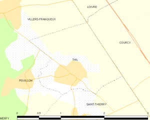
Thil
- commune in Marne, France
- Country:
- Postal Code: 51220
- Coordinates: 49° 18' 55" N, 3° 57' 45" E
- GPS tracks (wikiloc): [Link]
- Area: 2.11 sq km
- Population: 295